
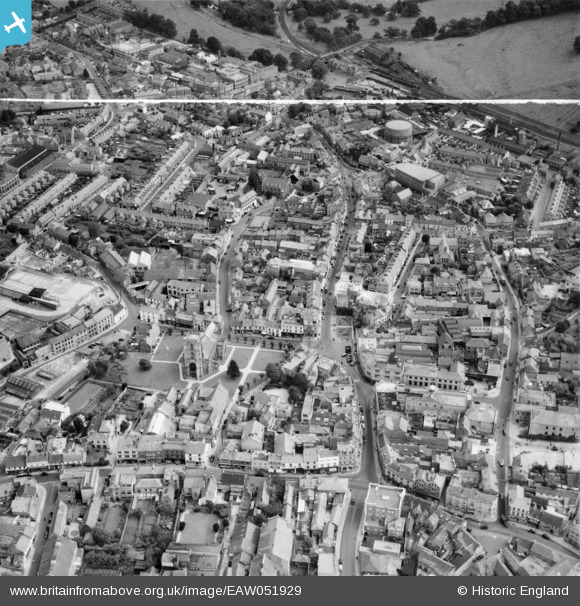
EAW051929 ENGLAND (1953). St John the Baptist's Church, Middle Street and the town centre, Yeovil, 1953. This image was marked by Aerofilms Ltd for photo editing.
© Copyright OpenStreetMap contributors and licensed by the OpenStreetMap Foundation. 2026. Cartography is licensed as CC BY-SA.
Nearby Images (18)
EAW051929

EPW011725

EPW024027

EAW051185

EAW051187

EPW024008

EPW024009

EAW051183

EAW051188

EAW051186

EPW024010

EPW024007

EPW024015

EPW048466

EPW011726

EPW048462

EAW051189

EAW051930

Details
| Title | [EAW051929] St John the Baptist's Church, Middle Street and the town centre, Yeovil, 1953. This image was marked by Aerofilms Ltd for photo editing. |
| Reference | EAW051929 |
| Date | 30-August-1953 |
| Link | |
| Place name | YEOVIL |
| Parish | YEOVIL |
| District | |
| Country | ENGLAND |
| Easting / Northing | 355754, 116000 |
| Longitude / Latitude | -2.6298252244403, 50.941193723847 |
| National Grid Reference | ST558160 |
Pins

mike |
Sunday 31st of January 2021 03:18:04 PM | |
Specifically, Yeovil Town station. The double track going off to the top of the picture climbs a bank towards Yeovil Junction and the single track to the left of the picture leads to Yeovil Pen Mill. |
Brightonboy |
Sunday 31st of January 2021 07:16:25 PM |

Class31 |
Sunday 1st of February 2015 05:23:33 PM |
