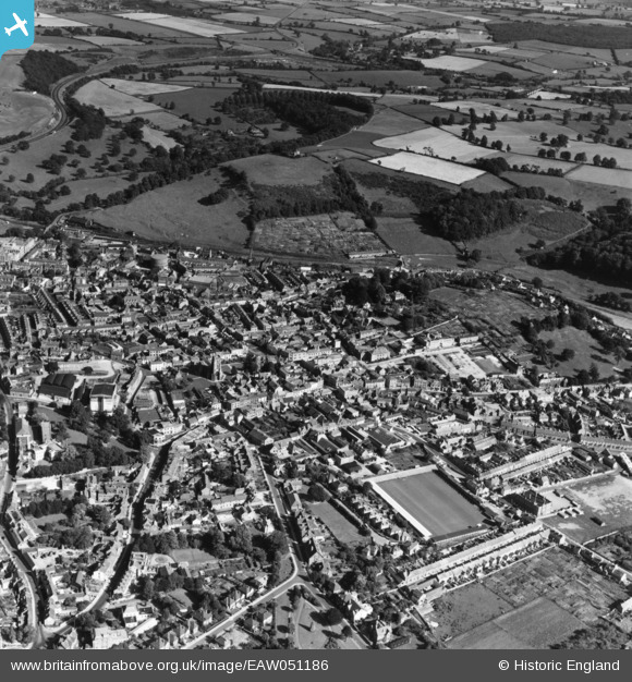
EAW051186 ENGLAND (1953). The town, Yeovil, 1953. This image has been produced from a print.
© Copyright OpenStreetMap contributors and licensed by the OpenStreetMap Foundation. 2025. Cartography is licensed as CC BY-SA.
Nearby Images (14)
Details
| Title | [EAW051186] The town, Yeovil, 1953. This image has been produced from a print. |
| Reference | EAW051186 |
| Date | 6-August-1953 |
| Link | |
| Place name | YEOVIL |
| Parish | YEOVIL |
| District | |
| Country | ENGLAND |
| Easting / Northing | 355813, 115860 |
| Longitude / Latitude | -2.6289684490757, 50.939939254205 |
| National Grid Reference | ST558159 |
Pins

Matt Aldred edob.mattaldred.com |
Wednesday 16th of July 2025 04:40:05 PM | |

gBr |
Tuesday 27th of October 2015 08:04:14 PM | |

Class31 |
Sunday 1st of February 2015 05:16:06 PM | |

Class31 |
Sunday 1st of February 2015 05:10:04 PM | |

Class31 |
Sunday 1st of February 2015 05:07:57 PM | |

Class31 |
Sunday 1st of February 2015 05:05:13 PM | |

Nowy Paul |
Sunday 1st of February 2015 04:45:43 PM | |

Nowy Paul |
Sunday 1st of February 2015 04:38:42 PM | |

Nowy Paul |
Sunday 1st of February 2015 04:34:47 PM | |

Nowy Paul |
Sunday 1st of February 2015 04:33:25 PM | |

Nowy Paul |
Sunday 1st of February 2015 04:28:26 PM | |

Nowy Paul |
Sunday 1st of February 2015 04:26:27 PM |


![[EAW051186] The town, Yeovil, 1953. This image has been produced from a print.](http://britainfromabove.org.uk/sites/all/libraries/aerofilms-images/public/100x100/EAW/051/EAW051186.jpg)
![[EPW048466] The town, Yeovil, 1935. This image has been produced from a copy-negative.](http://britainfromabove.org.uk/sites/all/libraries/aerofilms-images/public/100x100/EPW/048/EPW048466.jpg)
![[EPW011725] The town centre, Yeovil, 1924. This image has been produced from a copy-negative.](http://britainfromabove.org.uk/sites/all/libraries/aerofilms-images/public/100x100/EPW/011/EPW011725.jpg)
![[EAW051187] The town, Yeovil, 1953. This image has been produced from a print.](http://britainfromabove.org.uk/sites/all/libraries/aerofilms-images/public/100x100/EAW/051/EAW051187.jpg)
![[EPW024015] Middle Street and environs, Yeovil, 1928](http://britainfromabove.org.uk/sites/all/libraries/aerofilms-images/public/100x100/EPW/024/EPW024015.jpg)
![[EAW051929] St John the Baptist's Church, Middle Street and the town centre, Yeovil, 1953. This image was marked by Aerofilms Ltd for photo editing.](http://britainfromabove.org.uk/sites/all/libraries/aerofilms-images/public/100x100/EAW/051/EAW051929.jpg)
![[EPW011726] Middle Street and environs, Yeovil, 1924. This image has been produced from a copy-negative.](http://britainfromabove.org.uk/sites/all/libraries/aerofilms-images/public/100x100/EPW/011/EPW011726.jpg)
![[EPW024007] The Methodist Church and environs, Yeovil, 1928](http://britainfromabove.org.uk/sites/all/libraries/aerofilms-images/public/100x100/EPW/024/EPW024007.jpg)
![[EAW051183] The town, Yeovil, 1953](http://britainfromabove.org.uk/sites/all/libraries/aerofilms-images/public/100x100/EAW/051/EAW051183.jpg)
![[EPW024010] Library and Municipal Buildings on King George Street, Yeovil, 1928](http://britainfromabove.org.uk/sites/all/libraries/aerofilms-images/public/100x100/EPW/024/EPW024010.jpg)
![[EAW051185] The town, Yeovil, 1953. This image has been produced from a print.](http://britainfromabove.org.uk/sites/all/libraries/aerofilms-images/public/100x100/EAW/051/EAW051185.jpg)
![[EPW024027] The town centre, Yeovil, 1928](http://britainfromabove.org.uk/sites/all/libraries/aerofilms-images/public/100x100/EPW/024/EPW024027.jpg)
![[EPW024008] St John the Baptist's Church, Yeovil, 1928](http://britainfromabove.org.uk/sites/all/libraries/aerofilms-images/public/100x100/EPW/024/EPW024008.jpg)
![[EPW024009] St John the Baptist's Church, Yeovil, 1928](http://britainfromabove.org.uk/sites/all/libraries/aerofilms-images/public/100x100/EPW/024/EPW024009.jpg)


