
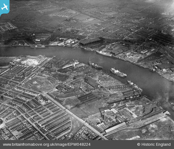
EPW048224 ENGLAND (1935). The industrial area alongside the River Tyne, Hebburn, 1935
© Hawlfraint cyfranwyr OpenStreetMap a thrwyddedwyd gan yr OpenStreetMap Foundation. 2026. Trwyddedir y gartograffeg fel CC BY-SA.
Delweddau cyfagos (20)
EPW048224

EPW050752

EAW017461

EAW002157

EPW050751

EPW048228

EPW050753

EPW048787

EPW051071

EPW051074

EPW048786

EAW010659

EPW051070

EPW051073

EAW002155

EPW051075

EPW051072

EPW048226

EAW010658

EPW007380

Manylion
| Pennawd | [EPW048224] The industrial area alongside the River Tyne, Hebburn, 1935 |
| Cyfeirnod | EPW048224 |
| Dyddiad | July-1935 |
| Dolen | |
| Enw lle | HEBBURN |
| Plwyf | |
| Ardal | |
| Gwlad | ENGLAND |
| Dwyreiniad / Gogleddiad | 430597, 565556 |
| Hydred / Lledred | -1.5218337072207, 54.983587704218 |
| Cyfeirnod Grid Cenedlaethol | NZ306656 |
Pinnau

N Dunn |
Monday 6th of April 2015 03:14:05 PM | |
|
N Dunn |
Monday 6th of April 2015 03:13:35 PM | |
|
N Dunn |
Monday 6th of April 2015 03:13:03 PM | |
|
N Dunn |
Monday 6th of April 2015 03:11:32 PM | |
|
N Dunn |
Monday 6th of April 2015 03:07:57 PM | |
|
N Dunn |
Monday 6th of April 2015 03:06:13 PM | |
|
N Dunn |
Monday 6th of April 2015 03:05:04 PM | |
|
N Dunn |
Monday 6th of April 2015 03:03:06 PM | |
|
N Dunn |
Monday 6th of April 2015 03:00:14 PM | |
|
N Dunn |
Monday 6th of April 2015 02:59:15 PM | |
|
N Dunn |
Monday 6th of April 2015 02:56:33 PM | |
|
N Dunn |
Monday 6th of April 2015 02:54:56 PM | |
|
N Dunn |
Monday 5th of May 2014 02:32:25 PM | |
|
N Dunn |
Wednesday 25th of September 2013 06:03:02 PM | |
|
N Dunn |
Wednesday 25th of September 2013 06:00:03 PM | |
|
N Dunn |
Wednesday 25th of September 2013 05:59:19 PM | |
|
N Dunn |
Wednesday 3rd of July 2013 03:11:10 PM | |
|
N Dunn |
Wednesday 3rd of July 2013 03:09:50 PM | |
|
N Dunn |
Wednesday 3rd of July 2013 03:09:07 PM | |
|
N Dunn |
Wednesday 3rd of July 2013 03:07:03 PM | |
Hawthorn,Leslie & Co were the builders of the SS Waipara 1904 on which my dad emigrated to Australia in 1914. |
Blair |
Tuesday 17th of February 2015 02:15:26 AM |
|
N Dunn |
Wednesday 3rd of July 2013 03:06:45 PM | |
|
N Dunn |
Wednesday 3rd of July 2013 03:06:23 PM | |

Dylan Moore |
Sunday 5th of May 2013 09:48:01 PM |