
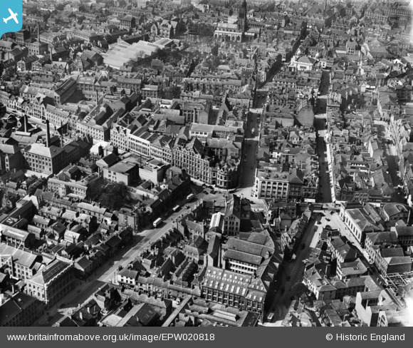
EPW020818 ENGLAND (1928). Pocklingtons Walk and environs, Leicester, 1928
© Hawlfraint cyfranwyr OpenStreetMap a thrwyddedwyd gan yr OpenStreetMap Foundation. 2026. Trwyddedir y gartograffeg fel CC BY-SA.
Delweddau cyfagos (22)
EPW020818

EAW051830

EPW020825

EPW018415

EPW020814

EPW018461

EPW020816

EPW020826

EPW020815

EPW020817

EAW024241

EPW020819

EPW055010

EPW020822

EAW051828

EPW020824

EPW018420

EPW008477

EPW047868

EPW008476

EPW047642

EPW018421

Manylion
| Pennawd | [EPW020818] Pocklingtons Walk and environs, Leicester, 1928 |
| Cyfeirnod | EPW020818 |
| Dyddiad | April-1928 |
| Dolen | |
| Enw lle | LEICESTER |
| Plwyf | |
| Ardal | |
| Gwlad | ENGLAND |
| Dwyreiniad / Gogleddiad | 458705, 304141 |
| Hydred / Lledred | -1.1325218511149, 52.631492618492 |
| Cyfeirnod Grid Cenedlaethol | SK587041 |
Pinnau

Class31 |
Tuesday 12th of February 2013 08:46:24 AM | |
|
Class31 |
Tuesday 12th of February 2013 08:43:36 AM | |
|
Class31 |
Tuesday 12th of February 2013 08:42:50 AM | |
|
Class31 |
Tuesday 12th of February 2013 08:42:22 AM | |
|
Class31 |
Tuesday 12th of February 2013 08:42:04 AM | |
|
Class31 |
Tuesday 12th of February 2013 08:41:39 AM | |
|
Class31 |
Tuesday 12th of February 2013 08:41:10 AM | |
|
Class31 |
Tuesday 12th of February 2013 08:40:45 AM | |
|
Class31 |
Sunday 10th of February 2013 11:35:37 PM | |
|
Class31 |
Sunday 10th of February 2013 11:31:32 PM | |
|
Class31 |
Sunday 10th of February 2013 11:21:53 PM | |

deeb |
Sunday 9th of December 2012 02:55:35 PM | |
St. Martin's Cathedral Church |
Class31 |
Sunday 10th of February 2013 11:34:04 PM |