
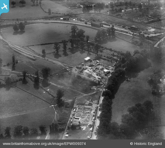
EPW009374 ENGLAND (1923). Construction of underground station, Edgware, 1923
© Copyright OpenStreetMap contributors and licensed by the OpenStreetMap Foundation. 2026. Cartography is licensed as CC BY-SA.
Nearby Images (33)
EPW009374

EPW031551

EPW034620

EPW031554

EPW015770

EPW016514

EPW009342

EPW009341

EPW016513

EPW009343

EPW031553

EPW009373

EPW034554

EPW034613

EPW009376

EAW048861

EPW034618

EAW020695

EPW009603

EPW034610

EPW034615

EPW034614

EPW016516

EPW031555

EPW031552

EPW031556

EAW020694

EPW015985

EPW009349

EAW033373

EPW015982

EPW034609

EPW034553

Details
| Title | [EPW009374] Construction of underground station, Edgware, 1923 |
| Reference | EPW009374 |
| Date | 1923 |
| Link | |
| Place name | EDGWARE |
| Parish | |
| District | |
| Country | ENGLAND |
| Easting / Northing | 519586, 191906 |
| Longitude / Latitude | -0.27268291657946, 51.612795165123 |
| National Grid Reference | TQ196919 |
Pins

Class31 |
Tuesday 30th of July 2013 11:16:27 PM |
User Comment Contributions
Station Road 18/02/2014 |
Class31 |
Wednesday 30th of April 2014 09:44:07 AM |

And so to Edgware, which chronologically should have first but as a Burnt Oak boy Burnt Oak comes first. The tube station as we can see is being constructed in green fields beyond the boundaries of the village, yet already the urbanisation of Church Lane is under way with a parade of shops under construction in what was to become Station Rd. |

colsouth111 |
Wednesday 12th of June 2013 07:30:57 PM |