
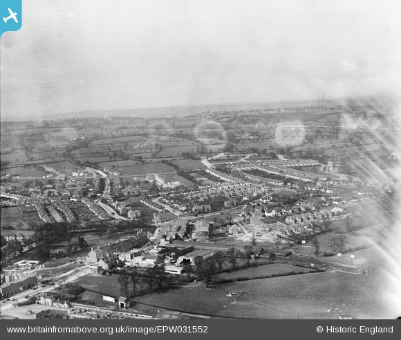
EPW031552 ENGLAND (1930). Edgware London Electric Railway Station and surroundings, Edgware, from the south, 1930
© Copyright OpenStreetMap contributors and licensed by the OpenStreetMap Foundation. 2026. Cartography is licensed as CC BY-SA.
Nearby Images (24)
EPW031552

EPW015985

EPW031555

EPW009373

EPW034618

EPW016513

EPW034553

EPW031553

EPW016515

EPW031554

EPW034620

EPW015770

EAW033373

EPW009376

EPW009343

EPW016514

EAW048861

EPW009342

EPW009374

EPW031551

EPW009341

EPW016516

EPW009603

EPW034612

Details
| Title | [EPW031552] Edgware London Electric Railway Station and surroundings, Edgware, from the south, 1930 |
| Reference | EPW031552 |
| Date | February-1930 |
| Link | |
| Place name | EDGWARE |
| Parish | |
| District | |
| Country | ENGLAND |
| Easting / Northing | 519536, 192093 |
| Longitude / Latitude | -0.27334097861983, 51.61448658789 |
| National Grid Reference | TQ195921 |
Pins

Class31 |
Tuesday 30th of July 2013 08:56:01 AM | |
|
Class31 |
Tuesday 30th of July 2013 08:55:26 AM | |
|
Class31 |
Tuesday 30th of July 2013 08:54:50 AM | |
|
Class31 |
Tuesday 30th of July 2013 08:53:49 AM | |
|
Class31 |
Tuesday 30th of July 2013 08:53:26 AM | |
|
Class31 |
Tuesday 30th of July 2013 08:53:07 AM | |
|
Class31 |
Tuesday 30th of July 2013 08:52:31 AM | |
|
Class31 |
Tuesday 30th of July 2013 08:51:52 AM |
User Comment Contributions
Station Road 18/02/2014 |
Class31 |
Wednesday 30th of April 2014 09:39:40 AM |