
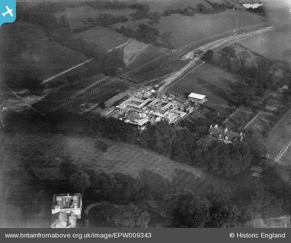
EPW009343 ENGLAND (1923). Construction of the underground station, Edgware, 1923
© Copyright OpenStreetMap contributors and licensed by the OpenStreetMap Foundation. 2026. Cartography is licensed as CC BY-SA.
Nearby Images (33)
EPW009343

EPW009376

EAW048861

EPW009342

EPW009341

EPW031553

EPW016514

EPW009603

EPW016516

EPW016513

EPW034618

EPW009373

EPW015770

EPW031551

EPW034620

EPW009374

EPW031554

EAW020695

EPW034554

EPW031555

EPW031552

EPW034612

EPW034614

EPW034613

EPW015985

EPW031556

EPW015982

EPW034553

EPW034615

EPW034610

EPW034621

EAW020694

EAW033373

Details
| Title | [EPW009343] Construction of the underground station, Edgware, 1923 |
| Reference | EPW009343 |
| Date | 1923 |
| Link | |
| Place name | EDGWARE |
| Parish | |
| District | |
| Country | ENGLAND |
| Easting / Northing | 519480, 191918 |
| Longitude / Latitude | -0.27420915580958, 51.612925535035 |
| National Grid Reference | TQ195919 |
Pins
Be the first to add a comment to this image!