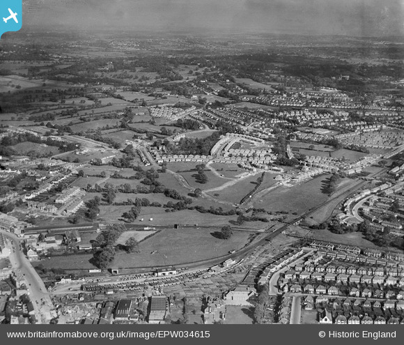
EPW034615 ENGLAND (1930). A new housing estate under construction near Lower Hale, Edgware, from the south-west, 1930
© Copyright OpenStreetMap contributors and licensed by the OpenStreetMap Foundation. 2026. Cartography is licensed as CC BY-SA.
Nearby Images (29)
Details
| Title | [EPW034615] A new housing estate under construction near Lower Hale, Edgware, from the south-west, 1930 |
| Reference | EPW034615 |
| Date | 16-October-1930 |
| Link | |
| Place name | EDGWARE |
| Parish | |
| District | |
| Country | ENGLAND |
| Easting / Northing | 519688, 191802 |
| Longitude / Latitude | -0.27124585622498, 51.61183870816 |
| National Grid Reference | TQ197918 |
Pins

Class31 |
Wednesday 7th of August 2013 11:44:55 PM | |

Class31 |
Wednesday 7th of August 2013 11:44:29 PM | |

Class31 |
Wednesday 7th of August 2013 11:43:56 PM | |

Class31 |
Wednesday 7th of August 2013 11:43:10 PM | |

Class31 |
Wednesday 7th of August 2013 11:42:36 PM | |

Class31 |
Wednesday 7th of August 2013 11:42:20 PM | |

Class31 |
Wednesday 7th of August 2013 11:41:36 PM | |

Class31 |
Wednesday 7th of August 2013 11:40:52 PM |


![[EPW034615] A new housing estate under construction near Lower Hale, Edgware, from the south-west, 1930](http://britainfromabove.org.uk/sites/all/libraries/aerofilms-images/public/100x100/EPW/034/EPW034615.jpg)
![[EPW034613] A new housing estate under construction near Lower Hale, Edgware, from the south-west, 1930](http://britainfromabove.org.uk/sites/all/libraries/aerofilms-images/public/100x100/EPW/034/EPW034613.jpg)
![[EPW034610] A new housing estate under construction near Lower Hale, Edgware, from the south-west, 1930](http://britainfromabove.org.uk/sites/all/libraries/aerofilms-images/public/100x100/EPW/034/EPW034610.jpg)
![[EAW020694] Central Edgware and the view towards Stanmore, Edgware, from the south-east, 1948](http://britainfromabove.org.uk/sites/all/libraries/aerofilms-images/public/100x100/EAW/020/EAW020694.jpg)
![[EPW009349] Construction of the Northern Line, Edgware, 1923](http://britainfromabove.org.uk/sites/all/libraries/aerofilms-images/public/100x100/EPW/009/EPW009349.jpg)
![[EPW034614] A new housing estate under construction near Lower Hale, Edgware, from the south-west, 1930](http://britainfromabove.org.uk/sites/all/libraries/aerofilms-images/public/100x100/EPW/034/EPW034614.jpg)
![[EPW034554] The railway and underground stations and environs, Edgware, from the south-east, 1930](http://britainfromabove.org.uk/sites/all/libraries/aerofilms-images/public/100x100/EPW/034/EPW034554.jpg)
![[EPW034609] A new housing estate under construction near Lower Hale, Edgware, from the south-west, 1930](http://britainfromabove.org.uk/sites/all/libraries/aerofilms-images/public/100x100/EPW/034/EPW034609.jpg)
![[EPW009374] Construction of underground station, Edgware, 1923](http://britainfromabove.org.uk/sites/all/libraries/aerofilms-images/public/100x100/EPW/009/EPW009374.jpg)
![[EPW031551] Edgware London Electric Railway Station and surroundings, Edgware, from the south-west, 1930](http://britainfromabove.org.uk/sites/all/libraries/aerofilms-images/public/100x100/EPW/031/EPW031551.jpg)
![[EPW031554] Edgware London Electric Railway Station, Station Road and surroundings, Edgware, 1930](http://britainfromabove.org.uk/sites/all/libraries/aerofilms-images/public/100x100/EPW/031/EPW031554.jpg)
![[EPW034620] Housing development around Green Lane and the railway stations, Edgware, from the south-east, 1930](http://britainfromabove.org.uk/sites/all/libraries/aerofilms-images/public/100x100/EPW/034/EPW034620.jpg)
![[EPW015770] Edgware underground station, Edgware, 1926](http://britainfromabove.org.uk/sites/all/libraries/aerofilms-images/public/100x100/EPW/015/EPW015770.jpg)
![[EAW020695] Central Edgware, Edgware, 1948](http://britainfromabove.org.uk/sites/all/libraries/aerofilms-images/public/100x100/EAW/020/EAW020695.jpg)
![[EPW016514] The underground station and bus depot, Edgware, 1926](http://britainfromabove.org.uk/sites/all/libraries/aerofilms-images/public/100x100/EPW/016/EPW016514.jpg)
![[EPW031556] Edgware Railway Station and surroundings, Edgware, from the north-west, 1930](http://britainfromabove.org.uk/sites/all/libraries/aerofilms-images/public/100x100/EPW/031/EPW031556.jpg)
![[EPW009341] Construction of the underground station, Edgware, 1923](http://britainfromabove.org.uk/sites/all/libraries/aerofilms-images/public/100x100/EPW/009/EPW009341.jpg)
![[EPW009342] Construction of the underground station, Edgware, 1923](http://britainfromabove.org.uk/sites/all/libraries/aerofilms-images/public/100x100/EPW/009/EPW009342.jpg)
![[EPW016513] The underground station and bus depot, Edgware, 1926](http://britainfromabove.org.uk/sites/all/libraries/aerofilms-images/public/100x100/EPW/016/EPW016513.jpg)
![[EPW034561] New housing at Orchard Crescent and environs, Edgware, from the south-west, 1930](http://britainfromabove.org.uk/sites/all/libraries/aerofilms-images/public/100x100/EPW/034/EPW034561.jpg)
![[EPW009343] Construction of the underground station, Edgware, 1923](http://britainfromabove.org.uk/sites/all/libraries/aerofilms-images/public/100x100/EPW/009/EPW009343.jpg)
![[EPW009603] Station Road and environs, Edgware, 1923](http://britainfromabove.org.uk/sites/all/libraries/aerofilms-images/public/100x100/EPW/009/EPW009603.jpg)
![[EPW031553] Edgware London Electric Railway Station, Station Road and surroundings, Edgware, from the south, 1930](http://britainfromabove.org.uk/sites/all/libraries/aerofilms-images/public/100x100/EPW/031/EPW031553.jpg)
![[EAW048861] Edgware Tube Station and the surrounding residential area, Edgware, 1953](http://britainfromabove.org.uk/sites/all/libraries/aerofilms-images/public/100x100/EAW/048/EAW048861.jpg)
![[EPW009376] Construction of underground station, Edgware, 1923](http://britainfromabove.org.uk/sites/all/libraries/aerofilms-images/public/100x100/EPW/009/EPW009376.jpg)
![[EPW009373] Construction of underground station, Edgware, 1923](http://britainfromabove.org.uk/sites/all/libraries/aerofilms-images/public/100x100/EPW/009/EPW009373.jpg)
![[EPW015982] Edgware Railway Station, Edgware, 1926. This image has been produced from a copy-negative.](http://britainfromabove.org.uk/sites/all/libraries/aerofilms-images/public/100x100/EPW/015/EPW015982.jpg)
![[EPW005282] Wright and Sons Tool Works at Thorn Bank, Edgware, 1921](http://britainfromabove.org.uk/sites/all/libraries/aerofilms-images/public/100x100/EPW/005/EPW005282.jpg)
![[EPW034618] Housing development around Green Lane and the railway stations, Edgware, from the south-east, 1930](http://britainfromabove.org.uk/sites/all/libraries/aerofilms-images/public/100x100/EPW/034/EPW034618.jpg)