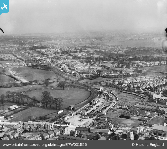
EPW031556 ENGLAND (1930). Edgware Railway Station and surroundings, Edgware, from the north-west, 1930
© Copyright OpenStreetMap contributors and licensed by the OpenStreetMap Foundation. 2026. Cartography is licensed as CC BY-SA.
Nearby Images (29)
Details
| Title | [EPW031556] Edgware Railway Station and surroundings, Edgware, from the north-west, 1930 |
| Reference | EPW031556 |
| Date | February-1930 |
| Link | |
| Place name | EDGWARE |
| Parish | |
| District | |
| Country | ENGLAND |
| Easting / Northing | 519516, 191709 |
| Longitude / Latitude | -0.27376069734655, 51.611039347809 |
| National Grid Reference | TQ195917 |
Pins

Class31 |
Wednesday 30th of April 2014 10:47:44 AM | |

Class31 |
Wednesday 30th of April 2014 09:26:06 AM | |

Class31 |
Tuesday 30th of July 2013 08:05:58 AM | |

Class31 |
Tuesday 30th of July 2013 08:05:07 AM | |

Class31 |
Tuesday 30th of July 2013 08:04:43 AM | |

Class31 |
Tuesday 30th of July 2013 08:04:26 AM | |

snapper31 |
Monday 7th of January 2013 03:12:23 PM | |

snapper31 |
Monday 7th of January 2013 03:10:42 PM | |

gazzavc |
Tuesday 26th of June 2012 04:46:48 AM |
User Comment Contributions

Puffpuffbuff |
Tuesday 26th of June 2012 03:18:04 PM | |
Another great picture of the original Edgware LNER station and goods yard, which extended through to Finsbury Park, via what is now Mill Hill East. You can see the Northern Line passing under the LNER line in the distance. |

gazzavc |
Tuesday 26th of June 2012 04:45:56 AM |


![[EPW031556] Edgware Railway Station and surroundings, Edgware, from the north-west, 1930](http://britainfromabove.org.uk/sites/all/libraries/aerofilms-images/public/100x100/EPW/031/EPW031556.jpg)
![[EPW015982] Edgware Railway Station, Edgware, 1926. This image has been produced from a copy-negative.](http://britainfromabove.org.uk/sites/all/libraries/aerofilms-images/public/100x100/EPW/015/EPW015982.jpg)
![[EPW005282] Wright and Sons Tool Works at Thorn Bank, Edgware, 1921](http://britainfromabove.org.uk/sites/all/libraries/aerofilms-images/public/100x100/EPW/005/EPW005282.jpg)
![[EAW020695] Central Edgware, Edgware, 1948](http://britainfromabove.org.uk/sites/all/libraries/aerofilms-images/public/100x100/EAW/020/EAW020695.jpg)
![[EPW034614] A new housing estate under construction near Lower Hale, Edgware, from the south-west, 1930](http://britainfromabove.org.uk/sites/all/libraries/aerofilms-images/public/100x100/EPW/034/EPW034614.jpg)
![[EPW034554] The railway and underground stations and environs, Edgware, from the south-east, 1930](http://britainfromabove.org.uk/sites/all/libraries/aerofilms-images/public/100x100/EPW/034/EPW034554.jpg)
![[EPW005277] Wright and Sons Tool Works at Thorn Bank, Edgware, 1921](http://britainfromabove.org.uk/sites/all/libraries/aerofilms-images/public/100x100/EPW/005/EPW005277.jpg)
![[EPW005281] Wright and Sons Tool Works at Thorn Bank, Edgware, 1921](http://britainfromabove.org.uk/sites/all/libraries/aerofilms-images/public/100x100/EPW/005/EPW005281.jpg)
![[EPW034613] A new housing estate under construction near Lower Hale, Edgware, from the south-west, 1930](http://britainfromabove.org.uk/sites/all/libraries/aerofilms-images/public/100x100/EPW/034/EPW034613.jpg)
![[EPW009603] Station Road and environs, Edgware, 1923](http://britainfromabove.org.uk/sites/all/libraries/aerofilms-images/public/100x100/EPW/009/EPW009603.jpg)
![[EPW009341] Construction of the underground station, Edgware, 1923](http://britainfromabove.org.uk/sites/all/libraries/aerofilms-images/public/100x100/EPW/009/EPW009341.jpg)
![[EPW016512] The railway station and environs, Edgware, 1926](http://britainfromabove.org.uk/sites/all/libraries/aerofilms-images/public/100x100/EPW/016/EPW016512.jpg)
![[EPW034615] A new housing estate under construction near Lower Hale, Edgware, from the south-west, 1930](http://britainfromabove.org.uk/sites/all/libraries/aerofilms-images/public/100x100/EPW/034/EPW034615.jpg)
![[EPW009342] Construction of the underground station, Edgware, 1923](http://britainfromabove.org.uk/sites/all/libraries/aerofilms-images/public/100x100/EPW/009/EPW009342.jpg)
![[EPW031551] Edgware London Electric Railway Station and surroundings, Edgware, from the south-west, 1930](http://britainfromabove.org.uk/sites/all/libraries/aerofilms-images/public/100x100/EPW/031/EPW031551.jpg)
![[EPW016514] The underground station and bus depot, Edgware, 1926](http://britainfromabove.org.uk/sites/all/libraries/aerofilms-images/public/100x100/EPW/016/EPW016514.jpg)
![[EPW009374] Construction of underground station, Edgware, 1923](http://britainfromabove.org.uk/sites/all/libraries/aerofilms-images/public/100x100/EPW/009/EPW009374.jpg)
![[EPW016516] The underground station, bus depot and environs, Edgware, 1926](http://britainfromabove.org.uk/sites/all/libraries/aerofilms-images/public/100x100/EPW/016/EPW016516.jpg)
![[EPW009343] Construction of the underground station, Edgware, 1923](http://britainfromabove.org.uk/sites/all/libraries/aerofilms-images/public/100x100/EPW/009/EPW009343.jpg)
![[EAW020694] Central Edgware and the view towards Stanmore, Edgware, from the south-east, 1948](http://britainfromabove.org.uk/sites/all/libraries/aerofilms-images/public/100x100/EAW/020/EAW020694.jpg)
![[EPW015770] Edgware underground station, Edgware, 1926](http://britainfromabove.org.uk/sites/all/libraries/aerofilms-images/public/100x100/EPW/015/EPW015770.jpg)
![[EAW048861] Edgware Tube Station and the surrounding residential area, Edgware, 1953](http://britainfromabove.org.uk/sites/all/libraries/aerofilms-images/public/100x100/EAW/048/EAW048861.jpg)
![[EPW009376] Construction of underground station, Edgware, 1923](http://britainfromabove.org.uk/sites/all/libraries/aerofilms-images/public/100x100/EPW/009/EPW009376.jpg)
![[EAW020693] Edgware and the view towards Borehamwood, Edgware, from the south, 1948](http://britainfromabove.org.uk/sites/all/libraries/aerofilms-images/public/100x100/EAW/020/EAW020693.jpg)
![[EPW034620] Housing development around Green Lane and the railway stations, Edgware, from the south-east, 1930](http://britainfromabove.org.uk/sites/all/libraries/aerofilms-images/public/100x100/EPW/034/EPW034620.jpg)
![[EPW034610] A new housing estate under construction near Lower Hale, Edgware, from the south-west, 1930](http://britainfromabove.org.uk/sites/all/libraries/aerofilms-images/public/100x100/EPW/034/EPW034610.jpg)
![[EPW031554] Edgware London Electric Railway Station, Station Road and surroundings, Edgware, 1930](http://britainfromabove.org.uk/sites/all/libraries/aerofilms-images/public/100x100/EPW/031/EPW031554.jpg)
![[EPW009349] Construction of the Northern Line, Edgware, 1923](http://britainfromabove.org.uk/sites/all/libraries/aerofilms-images/public/100x100/EPW/009/EPW009349.jpg)
![[EPW031553] Edgware London Electric Railway Station, Station Road and surroundings, Edgware, from the south, 1930](http://britainfromabove.org.uk/sites/all/libraries/aerofilms-images/public/100x100/EPW/031/EPW031553.jpg)

