
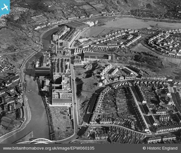
EPW060105 ENGLAND (1938). The St Anne's Board Mill Co Ltd Works and the surrounding residential area, Bristol, 1938
© Hawlfraint cyfranwyr OpenStreetMap a thrwyddedwyd gan yr OpenStreetMap Foundation. 2026. Trwyddedir y gartograffeg fel CC BY-SA.
Delweddau cyfagos (23)
EPW060105

EPW060114

EPW060109

EPW050468

EPW050567

EPW060113

EPW050566

EPW050561

EPW050470

EPW050469

EPW060111

EPW060110

EPW050562

EPW050465

EPW050572

EPW050559

EPW050565

EPW060112

EPW005538

EPW050571

EPW050564

EPW060106

EPW050570

Manylion
| Pennawd | [EPW060105] The St Anne's Board Mill Co Ltd Works and the surrounding residential area, Bristol, 1938 |
| Cyfeirnod | EPW060105 |
| Dyddiad | 1-November-1938 |
| Dolen | |
| Enw lle | BRISTOL |
| Plwyf | |
| Ardal | |
| Gwlad | ENGLAND |
| Dwyreiniad / Gogleddiad | 362006, 172746 |
| Hydred / Lledred | -2.5468428240434, 51.451932014407 |
| Cyfeirnod Grid Cenedlaethol | ST620727 |
Pinnau

Alan |
Monday 15th of December 2014 11:34:43 PM |