
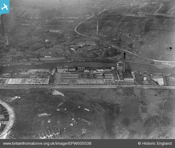
EPW005538 ENGLAND (1921). St Anne's Board Mill Co Ltd Works, Bristol, 1921
© Hawlfraint cyfranwyr OpenStreetMap a thrwyddedwyd gan yr OpenStreetMap Foundation. 2026. Trwyddedir y gartograffeg fel CC BY-SA.
Delweddau cyfagos (21)
EPW005538

EPW060110

EPW050566

EPW050561

EPW050567

EPW060114

EPW060113

EPW060105

EPW050565

EPW060111

EPW060112

EPW050571

EPW060106

EPW050559

EPW060109

EPW050470

EPW050572

EPW050468

EPW050465

EPW050564

EPW050469

Manylion
| Pennawd | [EPW005538] St Anne's Board Mill Co Ltd Works, Bristol, 1921 |
| Cyfeirnod | EPW005538 |
| Dyddiad | 20-March-1921 |
| Dolen | |
| Enw lle | BRISTOL |
| Plwyf | |
| Ardal | |
| Gwlad | ENGLAND |
| Dwyreiniad / Gogleddiad | 361965, 172885 |
| Hydred / Lledred | -2.5474478525993, 51.453179172379 |
| Cyfeirnod Grid Cenedlaethol | ST620729 |
Pinnau

Rob (Troopers) |
Tuesday 11th of May 2021 12:18:47 PM | |
|
kellysheppard510@ymail.com |
Monday 18th of July 2016 12:15:06 PM | |
|
pe175 |
Sunday 9th of June 2013 08:56:46 AM | |
|
MB |
Sunday 12th of May 2013 10:12:01 PM | |
Indicated on 1903 1:2,500 OS map |
MB |
Sunday 12th of May 2013 10:14:24 PM |
|
MB |
Sunday 12th of May 2013 10:10:04 PM | |
|
Mitch |
Tuesday 11th of December 2012 06:50:34 PM | |
|
Mitch |
Tuesday 11th of December 2012 06:49:39 PM | |

Class31 |
Wednesday 3rd of October 2012 07:52:00 PM | |
|
Class31 |
Wednesday 3rd of October 2012 07:49:54 PM | |
|
Class31 |
Thursday 12th of July 2012 09:01:35 PM | |
|
Class31 |
Thursday 12th of July 2012 09:00:25 PM | |
|
Class31 |
Thursday 12th of July 2012 08:57:57 PM | |
|
Alan Marshall |
Tuesday 26th of June 2012 04:10:40 PM |
Cyfraniadau Grŵp
I beleive this is St Annes Board Mills, St Annes,Bristol with the River Avon behind and on the opposite bank is Butlers Tar and Chemical Works,crews Hole Road, Hanham as seenin a number of other aerial photos. |
barrowroad |
Monday 16th of July 2012 10:33:27 PM |
Bristol, the Netham and St Annes. St Annes Board Mill in foreground together with site of medieval chapel of St Anne. Across the river are the Netham and Blackswarth Road. |
J Bryant |
Friday 13th of July 2012 01:34:53 PM |
The road is Blackswarth Road before the building of Fireclay Rd and the bridge over the lock at the Netham. The chimney is just about where Satellite House is now & if you look closely a little further up I think you can see the beginnings of St Patrick's, now very much more developed, and the Three Crowns. |
brambly |
Sunday 8th of July 2012 09:14:35 PM |

St Anne's Board Mills |
brambly |
Sunday 8th of July 2012 09:06:49 PM |
St Annes Board Mills, Bristol Date unknown |
mikel |
Sunday 8th of July 2012 09:38:01 AM |
I have just noticed that you can only see the very tall chimney on the left on a downloaded version of the picture. The picture when down loaded is wider than that shown on the web page. |
Mitch |
Tuesday 3rd of July 2012 11:27:06 PM |
Make the picture smaller and you can see all of the edge. |
Whittocks |
Tuesday 3rd of July 2012 11:27:06 PM |
Further to my previous comments, the section of water shown is of the River Avon. The Feeder Canal ends at the lock gates at the Netham bridge which is to the left and out of the photograph by 3 or 4 hundred yards. |
Mitch |
Tuesday 3rd of July 2012 10:31:30 PM |
This is a picture looking towards Netham Chemical Works. The factory in the foreground is Mardon Hall and Sons, a cardboard manufacturer. |
Namisan |
Monday 2nd of July 2012 02:51:53 PM |
Dear all, That’s great; we’ve reviewed your comments and thanks to your help we can update the catalogue. The revised record will appear here in due course. Hope you have the same success solving some of our other mysteries! Katy Whitaker Britain from Above Cataloguer |
Katy Whitaker |
Monday 2nd of July 2012 01:51:15 PM |
The Netham/ICI Chemical Work are the buildings to the left of center. The buildings in the middle distance are the Blacksworth Lead Works (ref Old Ordnance Survey Maps Bristol (St George) 1902). The very tall cimney just visable on left of photograph was at that time reputed to be the tallest in Bristol |
Mitch |
Sunday 1st of July 2012 09:22:23 PM |
THIS IS AN AERIAL VIEW OF THE NETHAM/ICI CHEMICAL / ALKALI WORKS IN THE REDFIELD/ST GEORGE/BARTON HILL DISTRICTS OF BRISTOL WITH THE FEEDER CANAL IN MID PHOTO. THE ST ANNES COUNCIL ESTATE IS SHOWN UNDER CONSTRUCTION AT THE BOTTOM OF THE PICTURE. THE CHIMNEY IS NOT THE ONE AT TROOPERS HILL - THAT IS FURTHER EAST OF THIS PHOTO OPPOSITE THE BUTLER TAR WORKS. |
JOHN BALMOND |
Sunday 1st of July 2012 02:05:14 AM |
St Anne's Board Mills |
Pathase |
Sunday 1st of July 2012 01:01:53 AM |
Looks like the Board Mills at St. Annes,Bristol, on the banks of the river Avon. Now no longer there, the chimney on the hill behind, on the other side of the river is on Troopers Hill and still exists. |
Wood2dust |
Tuesday 26th of June 2012 09:31:46 PM |
Troopers Hill is further up stream. The chimney of part of the quarry - as shown in maps of Bristol in 1900. The road is Blackswarth Road. |
Den Wright |
Tuesday 26th of June 2012 09:31:46 PM |
This is the Board Mills at St. Annes under construction. The butler Tar works are on the far bank of the river just out of the picture to the right. I would suggest the picture has been taken from above Broomhill/ Brislington |
Horace |
Tuesday 26th of June 2012 08:56:28 PM |
This is St Annes Board Mills,Brislington Bristol, part of the Mills to the left are still being built, and the first three houses have been built on Woodside Road, lower left. |
pe175 |
Tuesday 26th of June 2012 08:11:31 PM |