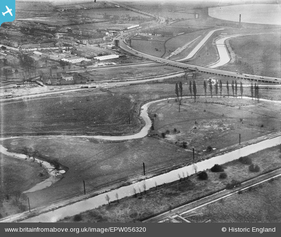
EPW056320 ENGLAND (1938). The River Lea at the southern end of the site of the William Girling Reservoir, Edmonton, 1938
© Hawlfraint cyfranwyr OpenStreetMap a thrwyddedwyd gan yr OpenStreetMap Foundation. 2026. Trwyddedir y gartograffeg fel CC BY-SA.
Delweddau cyfagos (24)
Manylion
| Pennawd | [EPW056320] The River Lea at the southern end of the site of the William Girling Reservoir, Edmonton, 1938 |
| Cyfeirnod | EPW056320 |
| Dyddiad | 4-February-1938 |
| Dolen | |
| Enw lle | EDMONTON |
| Plwyf | |
| Ardal | |
| Gwlad | ENGLAND |
| Dwyreiniad / Gogleddiad | 536077, 192508 |
| Hydred / Lledred | -0.034392602385359, 51.614460400729 |
| Cyfeirnod Grid Cenedlaethol | TQ361925 |
Pinnau
Byddwch y cyntaf i ychwanegu sylw at y ddelwedd hon!


![[EPW056320] The River Lea at the southern end of the site of the William Girling Reservoir, Edmonton, 1938](http://britainfromabove.org.uk/sites/all/libraries/aerofilms-images/public/100x100/EPW/056/EPW056320.jpg)
![[EPW055981] The William Girling Reservoir under construction at Chingford Mill Pumping Station, Edmonton, 1937](http://britainfromabove.org.uk/sites/all/libraries/aerofilms-images/public/100x100/EPW/055/EPW055981.jpg)
![[EPW050859] The River Lea at Lower Hall Lane, Edmonton, 1936](http://britainfromabove.org.uk/sites/all/libraries/aerofilms-images/public/100x100/EPW/050/EPW050859.jpg)
![[EPW058467] The River Lea, Chingford Mill Pumping Station and environs, Edmonton, 1938](http://britainfromabove.org.uk/sites/all/libraries/aerofilms-images/public/100x100/EPW/058/EPW058467.jpg)
![[EPW053836] The North Circular Road and the River Lea, Edmonton, 1937](http://britainfromabove.org.uk/sites/all/libraries/aerofilms-images/public/100x100/EPW/053/EPW053836.jpg)
![[EPW052271] The junction of Lower Hall Lane and the North Circular Road, Edmonton, 1936. This image has been produced from a damaged negative.](http://britainfromabove.org.uk/sites/all/libraries/aerofilms-images/public/100x100/EPW/052/EPW052271.jpg)
![[EPW058457] The North Circular Road Crossing the River Lea, Edmonton, 1938](http://britainfromabove.org.uk/sites/all/libraries/aerofilms-images/public/100x100/EPW/058/EPW058457.jpg)
![[EPW055980] The William Girling Reservoir under construction at Chingford Mill Pumping Station, Edmonton, 1937](http://britainfromabove.org.uk/sites/all/libraries/aerofilms-images/public/100x100/EPW/055/EPW055980.jpg)
![[EPW056823] The junction of Lower Hall Lane and the North Circular Road, Edmonton, 1938](http://britainfromabove.org.uk/sites/all/libraries/aerofilms-images/public/100x100/EPW/056/EPW056823.jpg)
![[EPW056816] The junction of the North Circular Road and Lower Hall Lane, Edmonton, 1938](http://britainfromabove.org.uk/sites/all/libraries/aerofilms-images/public/100x100/EPW/056/EPW056816.jpg)
![[EPW052287] The site of the southern end of the William Girling Reservoir showing preliminary construction works, Edmonton, 1936. This image has been produced from a damaged negative.](http://britainfromabove.org.uk/sites/all/libraries/aerofilms-images/public/100x100/EPW/052/EPW052287.jpg)
![[EPW056321] The junction of the North Circular Road and Lower Hall Lane, Edmonton, 1938](http://britainfromabove.org.uk/sites/all/libraries/aerofilms-images/public/100x100/EPW/056/EPW056321.jpg)
![[EPW049696] The area to the southern end of the William Girling Reservoir showing preliminary construction works, Edmonton, 1936](http://britainfromabove.org.uk/sites/all/libraries/aerofilms-images/public/100x100/EPW/049/EPW049696.jpg)
![[EPW056821] The River Lea at the southern end of the William Girling Reservoir, Edmonton, 1938](http://britainfromabove.org.uk/sites/all/libraries/aerofilms-images/public/100x100/EPW/056/EPW056821.jpg)
![[EPW052282] The junction of Lower Hall Lane and the North Circular Road, Edmonton, 1936. This image has been produced from a damaged negative.](http://britainfromabove.org.uk/sites/all/libraries/aerofilms-images/public/100x100/EPW/052/EPW052282.jpg)
![[EPW056319] The River Lea at the southern end of the site of the William Girling Reservoir, Edmonton, 1938](http://britainfromabove.org.uk/sites/all/libraries/aerofilms-images/public/100x100/EPW/056/EPW056319.jpg)
![[EPW049703] The junction of Lower Hall Lane and the North Circular Road and environs, Edmonton, 1936](http://britainfromabove.org.uk/sites/all/libraries/aerofilms-images/public/100x100/EPW/049/EPW049703.jpg)
![[EPW060635] Chingford Mill Pumping Station and the William Girling Reservoir under construction, Edmonton, 1939](http://britainfromabove.org.uk/sites/all/libraries/aerofilms-images/public/100x100/EPW/060/EPW060635.jpg)
![[EPW049523] Edmonton U.D. Council Sewage Farm, the Wireless Works and environs, Edmonton, 1935](http://britainfromabove.org.uk/sites/all/libraries/aerofilms-images/public/100x100/EPW/049/EPW049523.jpg)
![[EPW052274] The site of the southern end of the William Girling Reservoir showing preliminary construction works, Edmonton, 1936. This image has been produced from a damaged negative.](http://britainfromabove.org.uk/sites/all/libraries/aerofilms-images/public/100x100/EPW/052/EPW052274.jpg)
![[EPW056815] The William Girling Reservoir under construction, Edmonton, 1938](http://britainfromabove.org.uk/sites/all/libraries/aerofilms-images/public/100x100/EPW/056/EPW056815.jpg)
![[EPW018565] Cook's Ferry Public House and the Lea Valley Viaduct and environs, Edmonton, 1927](http://britainfromabove.org.uk/sites/all/libraries/aerofilms-images/public/100x100/EPW/018/EPW018565.jpg)
![[EPW018567] Cook's Ferry Public House and the Lea Valley Viaduct and environs, Edmonton, 1927](http://britainfromabove.org.uk/sites/all/libraries/aerofilms-images/public/100x100/EPW/018/EPW018567.jpg)
![[EPW053843] The River Lea and the southern part of the Chingford (William Girling) Reservoir under construction, Edmonton, 1937](http://britainfromabove.org.uk/sites/all/libraries/aerofilms-images/public/100x100/EPW/053/EPW053843.jpg)