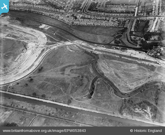
EPW053843 ENGLAND (1937). The River Lea and the southern part of the Chingford (William Girling) Reservoir under construction, Edmonton, 1937
© Hawlfraint cyfranwyr OpenStreetMap a thrwyddedwyd gan yr OpenStreetMap Foundation. 2026. Trwyddedir y gartograffeg fel CC BY-SA.
Delweddau cyfagos (23)
Manylion
| Pennawd | [EPW053843] The River Lea and the southern part of the Chingford (William Girling) Reservoir under construction, Edmonton, 1937 |
| Cyfeirnod | EPW053843 |
| Dyddiad | 25-June-1937 |
| Dolen | |
| Enw lle | EDMONTON |
| Plwyf | |
| Ardal | |
| Gwlad | ENGLAND |
| Dwyreiniad / Gogleddiad | 536221, 192750 |
| Hydred / Lledred | -0.032219784885996, 51.61660042736 |
| Cyfeirnod Grid Cenedlaethol | TQ362928 |
Pinnau
Byddwch y cyntaf i ychwanegu sylw at y ddelwedd hon!


![[EPW053843] The River Lea and the southern part of the Chingford (William Girling) Reservoir under construction, Edmonton, 1937](http://britainfromabove.org.uk/sites/all/libraries/aerofilms-images/public/100x100/EPW/053/EPW053843.jpg)
![[EPW056815] The William Girling Reservoir under construction, Edmonton, 1938](http://britainfromabove.org.uk/sites/all/libraries/aerofilms-images/public/100x100/EPW/056/EPW056815.jpg)
![[EPW052274] The site of the southern end of the William Girling Reservoir showing preliminary construction works, Edmonton, 1936. This image has been produced from a damaged negative.](http://britainfromabove.org.uk/sites/all/libraries/aerofilms-images/public/100x100/EPW/052/EPW052274.jpg)
![[EPW058461] The southern end of the Chingford (William Girling) Reservoir under construction and the River Lea, Edmonton, 1938](http://britainfromabove.org.uk/sites/all/libraries/aerofilms-images/public/100x100/EPW/058/EPW058461.jpg)
![[EPW058465] The southern part of the Chingford (William Girling) Reservoir under construction, Edmonton, 1938](http://britainfromabove.org.uk/sites/all/libraries/aerofilms-images/public/100x100/EPW/058/EPW058465.jpg)
![[EPW056319] The River Lea at the southern end of the site of the William Girling Reservoir, Edmonton, 1938](http://britainfromabove.org.uk/sites/all/libraries/aerofilms-images/public/100x100/EPW/056/EPW056319.jpg)
![[EPW056821] The River Lea at the southern end of the William Girling Reservoir, Edmonton, 1938](http://britainfromabove.org.uk/sites/all/libraries/aerofilms-images/public/100x100/EPW/056/EPW056821.jpg)
![[EPW060635] Chingford Mill Pumping Station and the William Girling Reservoir under construction, Edmonton, 1939](http://britainfromabove.org.uk/sites/all/libraries/aerofilms-images/public/100x100/EPW/060/EPW060635.jpg)
![[EPW049696] The area to the southern end of the William Girling Reservoir showing preliminary construction works, Edmonton, 1936](http://britainfromabove.org.uk/sites/all/libraries/aerofilms-images/public/100x100/EPW/049/EPW049696.jpg)
![[EPW049715] The site of the southern end of the William Girling Reservoir showing preliminary construction works, Edmonton, 1936](http://britainfromabove.org.uk/sites/all/libraries/aerofilms-images/public/100x100/EPW/049/EPW049715.jpg)
![[EPW055980] The William Girling Reservoir under construction at Chingford Mill Pumping Station, Edmonton, 1937](http://britainfromabove.org.uk/sites/all/libraries/aerofilms-images/public/100x100/EPW/055/EPW055980.jpg)
![[EPW052287] The site of the southern end of the William Girling Reservoir showing preliminary construction works, Edmonton, 1936. This image has been produced from a damaged negative.](http://britainfromabove.org.uk/sites/all/libraries/aerofilms-images/public/100x100/EPW/052/EPW052287.jpg)
![[EPW056326] The southern end of the William Girling Reservoir under construction, Edmonton, 1938](http://britainfromabove.org.uk/sites/all/libraries/aerofilms-images/public/100x100/EPW/056/EPW056326.jpg)
![[EPW060629] The William Girling Reservoir under construction, Edmonton, 1939. This image has been produced from a damaged negative.](http://britainfromabove.org.uk/sites/all/libraries/aerofilms-images/public/100x100/EPW/060/EPW060629.jpg)
![[EPW049523] Edmonton U.D. Council Sewage Farm, the Wireless Works and environs, Edmonton, 1935](http://britainfromabove.org.uk/sites/all/libraries/aerofilms-images/public/100x100/EPW/049/EPW049523.jpg)
![[EPW049528] The site of the William Girling Reservoir and Edmonton U.D. Council Sewage Farm, Edmonton, 1935](http://britainfromabove.org.uk/sites/all/libraries/aerofilms-images/public/100x100/EPW/049/EPW049528.jpg)
![[EPW056817] The southern end of the William Girling Reservoir under construction, Edmonton, 1938](http://britainfromabove.org.uk/sites/all/libraries/aerofilms-images/public/100x100/EPW/056/EPW056817.jpg)
![[EPW056822] The southern end of the William Girling Reservoir under construction, Edmonton, 1938](http://britainfromabove.org.uk/sites/all/libraries/aerofilms-images/public/100x100/EPW/056/EPW056822.jpg)
![[EPW058471] The Chingford (William Girling) Reservoir under construction, Edmonton, from the south, 1938](http://britainfromabove.org.uk/sites/all/libraries/aerofilms-images/public/100x100/EPW/058/EPW058471.jpg)
![[EPW053836] The North Circular Road and the River Lea, Edmonton, 1937](http://britainfromabove.org.uk/sites/all/libraries/aerofilms-images/public/100x100/EPW/053/EPW053836.jpg)
![[EPW055981] The William Girling Reservoir under construction at Chingford Mill Pumping Station, Edmonton, 1937](http://britainfromabove.org.uk/sites/all/libraries/aerofilms-images/public/100x100/EPW/055/EPW055981.jpg)
![[EPW056320] The River Lea at the southern end of the site of the William Girling Reservoir, Edmonton, 1938](http://britainfromabove.org.uk/sites/all/libraries/aerofilms-images/public/100x100/EPW/056/EPW056320.jpg)
![[EPW049722] Edmonton Urban District Council Sewage Farm and the site of the southern end of the William Girling Reservoir showing preliminary construction works, Edmonton, 1936](http://britainfromabove.org.uk/sites/all/libraries/aerofilms-images/public/100x100/EPW/049/EPW049722.jpg)