
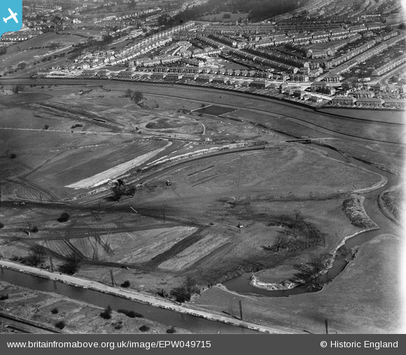
EPW049715 ENGLAND (1936). The site of the southern end of the William Girling Reservoir showing preliminary construction works, Edmonton, 1936
© Hawlfraint cyfranwyr OpenStreetMap a thrwyddedwyd gan yr OpenStreetMap Foundation. 2026. Trwyddedir y gartograffeg fel CC BY-SA.
Delweddau cyfagos (25)
EPW049715

EPW060629

EPW056326

EPW056817

EPW058461
 Reservoir under construction and the River Lea, Edmonton, 1938")
EPW058471
 Reservoir under construction, Edmonton, from the south, 1938")
EPW058465
 Reservoir under construction, Edmonton, 1938")
EPW056822

EPW049528

EPW052273

EPW049714

EPW055982

EPW053840
 Reservoir under construction, Edmonton, 1937")
EPW053843
 Reservoir under construction, Edmonton, 1937")
EPW050869

EPW056815

EPW053841
 Reservoir under construction, Edmonton, 1937")
EPW052274

EPW056319

EPW049702

EPW055987

EPW056821

EPW049696

EPW053855
 Reservoir under construction, Edmonton, 1937")
EPW049523

Manylion
| Pennawd | [EPW049715] The site of the southern end of the William Girling Reservoir showing preliminary construction works, Edmonton, 1936 |
| Cyfeirnod | EPW049715 |
| Dyddiad | March-1936 |
| Dolen | |
| Enw lle | EDMONTON |
| Plwyf | |
| Ardal | |
| Gwlad | ENGLAND |
| Dwyreiniad / Gogleddiad | 536250, 192898 |
| Hydred / Lledred | -0.031743574541999, 51.617923485895 |
| Cyfeirnod Grid Cenedlaethol | TQ363929 |
Pinnau
Byddwch y cyntaf i ychwanegu sylw at y ddelwedd hon!