
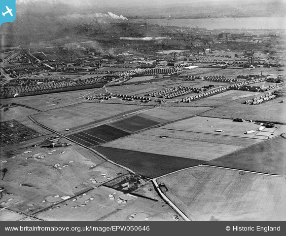
EPW050646 ENGLAND (1936). Bootle Golf Course, housing development around Kirkstone Road South and Church Road and environs, Litherland, from the north-east, 1936
© Hawlfraint cyfranwyr OpenStreetMap a thrwyddedwyd gan yr OpenStreetMap Foundation. 2026. Trwyddedir y gartograffeg fel CC BY-SA.
Delweddau cyfagos (6)
EPW050646

EPW050650

EPW050648

EAW050723

EPW050645

EPW050665

Manylion
| Pennawd | [EPW050646] Bootle Golf Course, housing development around Kirkstone Road South and Church Road and environs, Litherland, from the north-east, 1936 |
| Cyfeirnod | EPW050646 |
| Dyddiad | June-1936 |
| Dolen | |
| Enw lle | LITHERLAND |
| Plwyf | |
| Ardal | |
| Gwlad | ENGLAND |
| Dwyreiniad / Gogleddiad | 334871, 398657 |
| Hydred / Lledred | -2.9815112323717, 53.480348795027 |
| Cyfeirnod Grid Cenedlaethol | SJ349987 |
Pinnau

Lancashire Lass |
Wednesday 3rd of August 2022 02:37:29 PM | |
|
Phil T |
Friday 8th of April 2022 08:26:24 PM | |
|
Phil T |
Friday 8th of April 2022 08:19:38 PM | |
|
Alan Cooper |
Tuesday 29th of December 2020 05:51:26 PM | |
|
rivermersey |
Friday 29th of May 2020 11:31:43 AM | |
|
rivermersey |
Friday 29th of May 2020 11:26:45 AM | |
|
Lord Axminister |
Saturday 5th of March 2016 11:34:40 PM | |
|
Lord Axminister |
Monday 9th of June 2014 05:48:18 PM | |
|
Lord Axminister |
Monday 9th of June 2014 05:47:01 PM | |
|
Lord Axminister |
Monday 9th of June 2014 05:46:59 PM | |
|
Ronnie |
Wednesday 18th of December 2013 10:16:44 AM | |
|
Ange |
Saturday 17th of August 2013 10:27:34 PM |