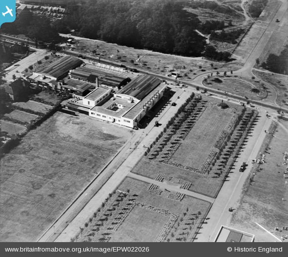
EPW022026 ENGLAND (1928). Parkway, Welwyn Garden City, 1928
© Hawlfraint cyfranwyr OpenStreetMap a thrwyddedwyd gan yr OpenStreetMap Foundation. 2026. Trwyddedir y gartograffeg fel CC BY-SA.
Delweddau cyfagos (33)
Manylion
| Pennawd | [EPW022026] Parkway, Welwyn Garden City, 1928 |
| Cyfeirnod | EPW022026 |
| Dyddiad | July-1928 |
| Dolen | |
| Enw lle | WELWYN GARDEN CITY |
| Plwyf | |
| Ardal | |
| Gwlad | ENGLAND |
| Dwyreiniad / Gogleddiad | 523627, 213185 |
| Hydred / Lledred | -0.20679590710274, 51.803173496235 |
| Cyfeirnod Grid Cenedlaethol | TL236132 |
Pinnau

Colin |
Tuesday 22nd of August 2017 07:28:22 AM | |

Chells809 |
Thursday 21st of February 2013 09:54:09 PM | |

Chells809 |
Thursday 21st of February 2013 09:52:34 PM |


![[EPW022026] Parkway, Welwyn Garden City, 1928](http://britainfromabove.org.uk/sites/all/libraries/aerofilms-images/public/100x100/EPW/022/EPW022026.jpg)
![[EPW025536] Rosanne House on Bridge Road, Welwyn Garden City, 1928. This image has been produced from a damaged negative.](http://britainfromabove.org.uk/sites/all/libraries/aerofilms-images/public/100x100/EPW/025/EPW025536.jpg)
![[EPW022024] Crowds at Parkway and The Welwyn Theatre, Welwyn Garden City, 1928](http://britainfromabove.org.uk/sites/all/libraries/aerofilms-images/public/100x100/EPW/022/EPW022024.jpg)
![[EPW062050] The town centre, Welwyn Garden City, from the north-west, 1939](http://britainfromabove.org.uk/sites/all/libraries/aerofilms-images/public/100x100/EPW/062/EPW062050.jpg)
![[EPW062003] Welwyn Garden City, the Grand Opening of Welwyn Stores, 1939](http://britainfromabove.org.uk/sites/all/libraries/aerofilms-images/public/100x100/EPW/062/EPW062003.jpg)
![[EPW062006] Welwyn Garden City, the Grand Opening of Welwyn Stores, 1939](http://britainfromabove.org.uk/sites/all/libraries/aerofilms-images/public/100x100/EPW/062/EPW062006.jpg)
![[EPW062001] Welwyn Garden City, the Grand Opening of Welwyn Stores, 1939](http://britainfromabove.org.uk/sites/all/libraries/aerofilms-images/public/100x100/EPW/062/EPW062001.jpg)
![[EPW025528] The Welwyn Theatre off Parkway, Welwyn Garden City, 1928. This image has been produced from a copy-negative.](http://britainfromabove.org.uk/sites/all/libraries/aerofilms-images/public/100x100/EPW/025/EPW025528.jpg)
![[EPW022023] Crowds at Parkway and Howards Gate, Welwyn Garden City, 1928](http://britainfromabove.org.uk/sites/all/libraries/aerofilms-images/public/100x100/EPW/022/EPW022023.jpg)
![[EPW062005] Welwyn Garden City, the Grand Opening of Welwyn Stores, 1939](http://britainfromabove.org.uk/sites/all/libraries/aerofilms-images/public/100x100/EPW/062/EPW062005.jpg)
![[EPW047366] Parkway and environs, Welwyn Garden City, 1935](http://britainfromabove.org.uk/sites/all/libraries/aerofilms-images/public/100x100/EPW/047/EPW047366.jpg)
![[EAW013994] The Campus, Bridge Road and the surrounding town, Welwyn Garden City, 1948](http://britainfromabove.org.uk/sites/all/libraries/aerofilms-images/public/100x100/EAW/013/EAW013994.jpg)
![[EPW062002] Welwyn Garden City, the Grand Opening of Welwyn Stores, 1939](http://britainfromabove.org.uk/sites/all/libraries/aerofilms-images/public/100x100/EPW/062/EPW062002.jpg)
![[EPW047362] Howardsgate and the railway station, Welwyn Garden City, 1935](http://britainfromabove.org.uk/sites/all/libraries/aerofilms-images/public/100x100/EPW/047/EPW047362.jpg)
![[EPW054493] Howardsgate and the town centre, Welwyn Garden City, 1937](http://britainfromabove.org.uk/sites/all/libraries/aerofilms-images/public/100x100/EPW/054/EPW054493.jpg)
![[EPW047363] Howardsgate, Welwyn Garden City, 1935](http://britainfromabove.org.uk/sites/all/libraries/aerofilms-images/public/100x100/EPW/047/EPW047363.jpg)
![[EPW047364] Howardsgate and the railway station, Welwyn Garden City, 1935](http://britainfromabove.org.uk/sites/all/libraries/aerofilms-images/public/100x100/EPW/047/EPW047364.jpg)
![[EPW047365] Howardsgate and environs, Welwyn Garden City, 1935](http://britainfromabove.org.uk/sites/all/libraries/aerofilms-images/public/100x100/EPW/047/EPW047365.jpg)
![[EPW022018] The Quadrangle and Russellcroft Road, Welwyn Garden City, 1928](http://britainfromabove.org.uk/sites/all/libraries/aerofilms-images/public/100x100/EPW/022/EPW022018.jpg)
![[EPW047356] Guessens Court, Russellcroft Road and environs, Welwyn Garden City, 1935](http://britainfromabove.org.uk/sites/all/libraries/aerofilms-images/public/100x100/EPW/047/EPW047356.jpg)
![[EPW054497] Howardsgate, Welwyn Garden City, 1937](http://britainfromabove.org.uk/sites/all/libraries/aerofilms-images/public/100x100/EPW/054/EPW054497.jpg)
![[EPW047357] Guessens Court, Guessens Road and environs, Welwyn Garden City, 1935](http://britainfromabove.org.uk/sites/all/libraries/aerofilms-images/public/100x100/EPW/047/EPW047357.jpg)
![[EPW022030] Russellcroft Road and Guessens Road, Welwyn Garden City, 1928](http://britainfromabove.org.uk/sites/all/libraries/aerofilms-images/public/100x100/EPW/022/EPW022030.jpg)
![[EPW054498] Howardsgate and the Shredded Wheat Cereal Manufactory, Welwyn Garden City, 1937](http://britainfromabove.org.uk/sites/all/libraries/aerofilms-images/public/100x100/EPW/054/EPW054498.jpg)
![[EPW054496] Howardsgate, the Railway Station and the Shredded Wheat Cereal Manufactory, Welwyn Garden City, 1937](http://britainfromabove.org.uk/sites/all/libraries/aerofilms-images/public/100x100/EPW/054/EPW054496.jpg)
![[EPW054533] Howardsgate and Stonehills, Welwyn Garden City, 1937](http://britainfromabove.org.uk/sites/all/libraries/aerofilms-images/public/100x100/EPW/054/EPW054533.jpg)
![[EPW047361] Howardsgate and the railway station, Welwyn Garden City, 1935](http://britainfromabove.org.uk/sites/all/libraries/aerofilms-images/public/100x100/EPW/047/EPW047361.jpg)
![[EPW022015] The Ebenezer Howard Memorial and the Shredded Wheat Factory, Welwyn Garden City, from the north-west, 1928](http://britainfromabove.org.uk/sites/all/libraries/aerofilms-images/public/100x100/EPW/022/EPW022015.jpg)
![[EPW047382] Digswell Junction and the Cherry Tree Restaurant, Welwyn Garden City, 1935](http://britainfromabove.org.uk/sites/all/libraries/aerofilms-images/public/100x100/EPW/047/EPW047382.jpg)
![[EPW062048] Digswell Road and environs, Welwyn Garden City, 1939](http://britainfromabove.org.uk/sites/all/libraries/aerofilms-images/public/100x100/EPW/062/EPW062048.jpg)
![[EPW047380] Digswell Junction and the Cherry Tree Restaurant, Welwyn Garden City, 1935](http://britainfromabove.org.uk/sites/all/libraries/aerofilms-images/public/100x100/EPW/047/EPW047380.jpg)
![[EPW047379] Guessens Court, Guessens Road and environs, Welwyn Garden City, 1935](http://britainfromabove.org.uk/sites/all/libraries/aerofilms-images/public/100x100/EPW/047/EPW047379.jpg)
![[EPW054540] The residential area surrounding Homerfield and Guessens Court, Welwyn Garden City, 1937. This image has been produced from a copy-negative.](http://britainfromabove.org.uk/sites/all/libraries/aerofilms-images/public/100x100/EPW/054/EPW054540.jpg)