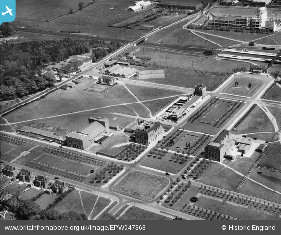
EPW047363 ENGLAND (1935). Howardsgate, Welwyn Garden City, 1935
© Hawlfraint cyfranwyr OpenStreetMap a thrwyddedwyd gan yr OpenStreetMap Foundation. 2026. Trwyddedir y gartograffeg fel CC BY-SA.
Delweddau cyfagos (27)
Manylion
| Pennawd | [EPW047363] Howardsgate, Welwyn Garden City, 1935 |
| Cyfeirnod | EPW047363 |
| Dyddiad | May-1935 |
| Dolen | |
| Enw lle | WELWYN GARDEN CITY |
| Plwyf | |
| Ardal | |
| Gwlad | ENGLAND |
| Dwyreiniad / Gogleddiad | 523756, 213038 |
| Hydred / Lledred | -0.20497824519626, 51.801823773971 |
| Cyfeirnod Grid Cenedlaethol | TL238130 |
Pinnau

John Wass |
Sunday 13th of March 2016 08:32:29 PM | |
The 'Fast lines' run through this station clear of any platforms. At this time the two pairs of platforms served the Slow up and down lines, and also the two branches, one to Luton and Dunstable and the other to Hertford. |

John W |
Wednesday 22nd of March 2017 11:04:40 PM |


![[EPW047363] Howardsgate, Welwyn Garden City, 1935](http://britainfromabove.org.uk/sites/all/libraries/aerofilms-images/public/100x100/EPW/047/EPW047363.jpg)
![[EPW054493] Howardsgate and the town centre, Welwyn Garden City, 1937](http://britainfromabove.org.uk/sites/all/libraries/aerofilms-images/public/100x100/EPW/054/EPW054493.jpg)
![[EPW047364] Howardsgate and the railway station, Welwyn Garden City, 1935](http://britainfromabove.org.uk/sites/all/libraries/aerofilms-images/public/100x100/EPW/047/EPW047364.jpg)
![[EPW054497] Howardsgate, Welwyn Garden City, 1937](http://britainfromabove.org.uk/sites/all/libraries/aerofilms-images/public/100x100/EPW/054/EPW054497.jpg)
![[EPW054496] Howardsgate, the Railway Station and the Shredded Wheat Cereal Manufactory, Welwyn Garden City, 1937](http://britainfromabove.org.uk/sites/all/libraries/aerofilms-images/public/100x100/EPW/054/EPW054496.jpg)
![[EPW054533] Howardsgate and Stonehills, Welwyn Garden City, 1937](http://britainfromabove.org.uk/sites/all/libraries/aerofilms-images/public/100x100/EPW/054/EPW054533.jpg)
![[EPW047362] Howardsgate and the railway station, Welwyn Garden City, 1935](http://britainfromabove.org.uk/sites/all/libraries/aerofilms-images/public/100x100/EPW/047/EPW047362.jpg)
![[EPW047365] Howardsgate and environs, Welwyn Garden City, 1935](http://britainfromabove.org.uk/sites/all/libraries/aerofilms-images/public/100x100/EPW/047/EPW047365.jpg)
![[EPW047361] Howardsgate and the railway station, Welwyn Garden City, 1935](http://britainfromabove.org.uk/sites/all/libraries/aerofilms-images/public/100x100/EPW/047/EPW047361.jpg)
![[EPW054498] Howardsgate and the Shredded Wheat Cereal Manufactory, Welwyn Garden City, 1937](http://britainfromabove.org.uk/sites/all/libraries/aerofilms-images/public/100x100/EPW/054/EPW054498.jpg)
![[EPW025528] The Welwyn Theatre off Parkway, Welwyn Garden City, 1928. This image has been produced from a copy-negative.](http://britainfromabove.org.uk/sites/all/libraries/aerofilms-images/public/100x100/EPW/025/EPW025528.jpg)
![[EPW022015] The Ebenezer Howard Memorial and the Shredded Wheat Factory, Welwyn Garden City, from the north-west, 1928](http://britainfromabove.org.uk/sites/all/libraries/aerofilms-images/public/100x100/EPW/022/EPW022015.jpg)
![[EPW022023] Crowds at Parkway and Howards Gate, Welwyn Garden City, 1928](http://britainfromabove.org.uk/sites/all/libraries/aerofilms-images/public/100x100/EPW/022/EPW022023.jpg)
![[EAW013995] Parkway, the town and environs, Welwyn Garden City, from the north-east, 1948](http://britainfromabove.org.uk/sites/all/libraries/aerofilms-images/public/100x100/EAW/013/EAW013995.jpg)
![[EPW062006] Welwyn Garden City, the Grand Opening of Welwyn Stores, 1939](http://britainfromabove.org.uk/sites/all/libraries/aerofilms-images/public/100x100/EPW/062/EPW062006.jpg)
![[EPW062002] Welwyn Garden City, the Grand Opening of Welwyn Stores, 1939](http://britainfromabove.org.uk/sites/all/libraries/aerofilms-images/public/100x100/EPW/062/EPW062002.jpg)
![[EPW022024] Crowds at Parkway and The Welwyn Theatre, Welwyn Garden City, 1928](http://britainfromabove.org.uk/sites/all/libraries/aerofilms-images/public/100x100/EPW/022/EPW022024.jpg)
![[EPW062005] Welwyn Garden City, the Grand Opening of Welwyn Stores, 1939](http://britainfromabove.org.uk/sites/all/libraries/aerofilms-images/public/100x100/EPW/062/EPW062005.jpg)
![[EPW062001] Welwyn Garden City, the Grand Opening of Welwyn Stores, 1939](http://britainfromabove.org.uk/sites/all/libraries/aerofilms-images/public/100x100/EPW/062/EPW062001.jpg)
![[EPW062003] Welwyn Garden City, the Grand Opening of Welwyn Stores, 1939](http://britainfromabove.org.uk/sites/all/libraries/aerofilms-images/public/100x100/EPW/062/EPW062003.jpg)
![[EPW022026] Parkway, Welwyn Garden City, 1928](http://britainfromabove.org.uk/sites/all/libraries/aerofilms-images/public/100x100/EPW/022/EPW022026.jpg)
![[EPW054513] The Railway Station, Howardsgate and Church Road, Welwyn Garden City, 1937](http://britainfromabove.org.uk/sites/all/libraries/aerofilms-images/public/100x100/EPW/054/EPW054513.jpg)
![[EPW025536] Rosanne House on Bridge Road, Welwyn Garden City, 1928. This image has been produced from a damaged negative.](http://britainfromabove.org.uk/sites/all/libraries/aerofilms-images/public/100x100/EPW/025/EPW025536.jpg)
![[EPW054505] The Cherry Tree Restaurant, Welwyn Garden City, 1937](http://britainfromabove.org.uk/sites/all/libraries/aerofilms-images/public/100x100/EPW/054/EPW054505.jpg)
![[EPW054502] The Cherry Tree Restaurant, Welwyn Garden City, 1937](http://britainfromabove.org.uk/sites/all/libraries/aerofilms-images/public/100x100/EPW/054/EPW054502.jpg)
![[EAW035461] The town and surrounding countryside, Welwyn Garden City, 1951. This image has been produced from a print.](http://britainfromabove.org.uk/sites/all/libraries/aerofilms-images/public/100x100/EAW/035/EAW035461.jpg)
![[EPW062050] The town centre, Welwyn Garden City, from the north-west, 1939](http://britainfromabove.org.uk/sites/all/libraries/aerofilms-images/public/100x100/EPW/062/EPW062050.jpg)