
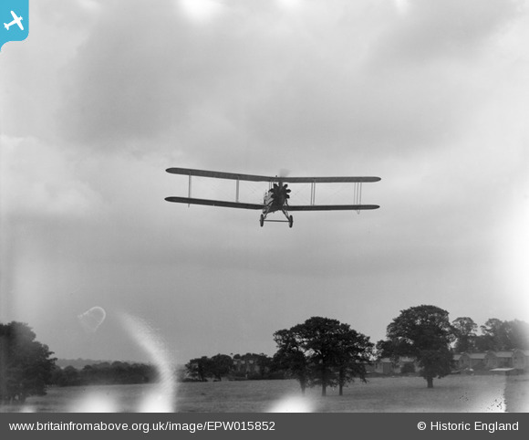
EPW015852 ENGLAND (1926). DH9A J7028 "Stag" undergoing flight trials at Stag Lane, Little Stanmore, 1926
© Hawlfraint cyfranwyr OpenStreetMap a thrwyddedwyd gan yr OpenStreetMap Foundation. 2026. Trwyddedir y gartograffeg fel CC BY-SA.
Delweddau cyfagos (48)
EPW015852

EPW015847

EPW015845

EPW015850

EPW015851

EPW030056

EPW025691

EPW032891

EPW015848

EPW031546

EPW015849

EPW046487

EPW025073

EPW030057

EPW030058

EPW022364

EPW047555

EPW034797

EPW047557

EPW047549

EPW047554

EPW032892

EPW031582

EPW031547

EPW013199

EPW013196

EPW034799

EPW032890

EPW025074

EPW047556

EPW034981

EPW034981
EPW018765

EPW047552

EPW047553

EPW047551

EPW022048

EPW018148

EPW032889

EPW046486

EPW009129

EPW047550

EPW046488

EPW013198

EPW046490

EPW046489

EPW034987

EPW034798

Manylion
| Pennawd | [EPW015852] DH9A J7028 "Stag" undergoing flight trials at Stag Lane, Little Stanmore, 1926 |
| Cyfeirnod | EPW015852 |
| Dyddiad | 16-June-1926 |
| Dolen | |
| Enw lle | LITTLE STANMORE |
| Plwyf | |
| Ardal | |
| Gwlad | ENGLAND |
| Dwyreiniad / Gogleddiad | 519685, 190284 |
| Hydred / Lledred | -0.27180739297857, 51.598195182216 |
| Cyfeirnod Grid Cenedlaethol | TQ197903 |
Pinnau

USTigger |
Wednesday 22nd of August 2012 07:47:31 AM | |

Class31 |
Tuesday 21st of August 2012 10:11:42 PM | |
|
Class31 |
Tuesday 21st of August 2012 09:47:58 PM |
Cyfraniadau Grŵp
Hullo! Thanks for taking a look at these ground shots of the Stag being flown about. They caused us some difficulty at the time we originally came to catalogue them, but your close examination has identified the detail on the Bank building which is the clincher for me. We'll update the catalogue entries and the details will appear here in due course, located to the fields in the top corner of the Stag Lane aerodrome, near to the lane. The couple of shots of the aircraft in the air with no terrestrial reference cause a little difficulty - normally we wouldn't give them spatial data. It is important, however, to retain the association of this group of images so in this instance I will give them a grid reference. Yours, Katy Britain from Above Cataloging Team Leader |
Katy Whitaker |
Thursday 7th of March 2013 12:56:27 PM |
Hi Glen37037, That's part of our problem with this little group of photos of the Stag. We know it was tested at Martlesham and following this it spent time based at Stag Lane, but we don't know when after testing it was flown to De Havilland's north London base. Could have been straight away, or maybe not. The fact that Aerofilms were photographing it suggests Stag Lane, given their nearby offices; and the test pilot was one of Aerofilms' pilots. But we need more information to confirm the location! Katy Whitaker Britain from Above Cataloguer |
Katy Whitaker |
Tuesday 21st of August 2012 10:01:35 PM |
Hi Katy I think that I have resolved the location as Stag Lane from the houses in the background. I shall look at individual trees to confirm the photos without buildings in the background! |
Class31 |
Tuesday 21st of August 2012 10:01:35 PM |
View looking east. |
Class31 |
Tuesday 21st of August 2012 09:58:19 PM |
The 'Stag' was actually a DH9AJ, the J suffix referring to the Bristol Jupiter radial engine it was powered by. This aircraft first flew on 15th June 1926 so the photograph's date of 16th June 1926 might give a clue to where the aircraft was flying the next day. |
Glen37037 |
Friday 29th of June 2012 02:00:54 PM |