
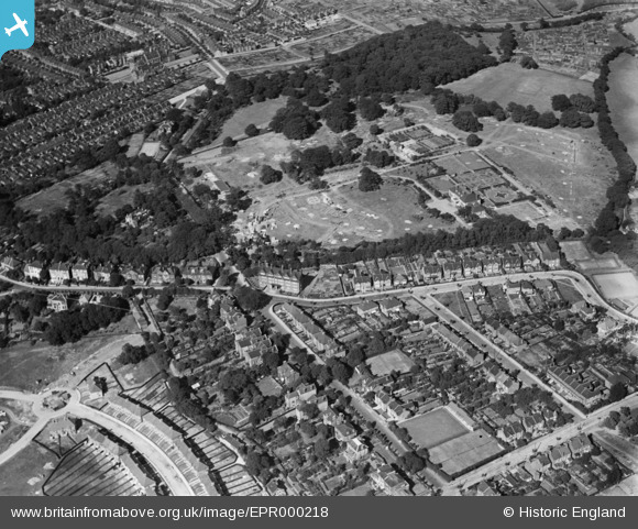
EPR000218 ENGLAND (1934). Eaglesfield Road and the Shrewsbury Park Estate under construction, Shooters Hill, 1934
© Hawlfraint cyfranwyr OpenStreetMap a thrwyddedwyd gan yr OpenStreetMap Foundation. 2026. Trwyddedir y gartograffeg fel CC BY-SA.
Delweddau cyfagos (10)
EPR000218

EPR000217

EPR000126

EPR000124

EPR000123

EPR000216

EPR000219

EPR000120

EPR000215

EPR000214

Manylion
| Pennawd | [EPR000218] Eaglesfield Road and the Shrewsbury Park Estate under construction, Shooters Hill, 1934 |
| Cyfeirnod | EPR000218 |
| Dyddiad | 17-July-1934 |
| Dolen | |
| Enw lle | SHOOTERS HILL |
| Plwyf | |
| Ardal | |
| Gwlad | ENGLAND |
| Dwyreiniad / Gogleddiad | 543943, 177020 |
| Hydred / Lledred | 0.072815961515465, 51.473320366601 |
| Cyfeirnod Grid Cenedlaethol | TQ439770 |
Pinnau

John W |
Friday 14th of April 2017 04:39:30 PM | |
|
John W |
Friday 14th of April 2017 04:38:42 PM | |
|
John W |
Friday 14th of April 2017 04:37:48 PM | |
|
John W |
Friday 14th of April 2017 04:37:18 PM | |
|
John W |
Friday 14th of April 2017 04:36:46 PM | |
|
John W |
Friday 14th of April 2017 04:35:48 PM | |
|
John W |
Friday 14th of April 2017 04:35:02 PM | |
|
John W |
Friday 14th of April 2017 04:34:28 PM | |
|
John W |
Friday 14th of April 2017 04:33:42 PM | |
|
John W |
Friday 14th of April 2017 04:33:18 PM | |
|
John W |
Friday 14th of April 2017 04:32:32 PM | |
|
South Londoner |
Wednesday 21st of December 2016 06:46:18 PM | |
|
RichMoly |
Sunday 11th of January 2015 02:54:59 PM |