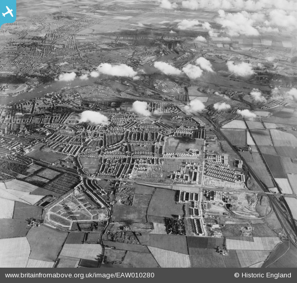
EAW010280 ENGLAND (1947). Development around West Chirton and Billy Mill, West Chirton, from the north, 1947
    © Hawlfraint cyfranwyr OpenStreetMap a thrwyddedwyd gan yr OpenStreetMap Foundation. 2025. Trwyddedir y gartograffeg fel CC BY-SA.
  
Delweddau cyfagos (8)
Manylion
| Pennawd | [EAW010280] Development around West Chirton and Billy Mill, West Chirton, from the north, 1947 | 
| Cyfeirnod | EAW010280 | 
| Dyddiad | 24-August-1947 | 
| Dolen | |
| Enw lle | WEST CHIRTON | 
| Plwyf | |
| Ardal | |
| Gwlad | ENGLAND | 
| Dwyreiniad / Gogleddiad | 433575, 568869 | 
| Hydred / Lledred | -1.4749072845537, 55.013169290271 | 
| Cyfeirnod Grid Cenedlaethol | NZ336689 | 
Pinnau
|  THE SITE OF WHAT WOULD BECOME GUNNERTON PLACE. |   dave | Sunday 15th of May 2016 09:10:47 AM | 
|  Formica |   bellringer | Wednesday 4th of June 2014 07:09:29 PM | 
|  Ralph Gardner's School - "Ralphies". |   Eric Hollerton | Saturday 21st of December 2013 05:17:16 PM | 
|  Ralph Gardner's School - "Ralphies". |   Eric Hollerton | Saturday 21st of December 2013 05:17:16 PM | 
|  Borough Road footbridge. The New Cut was dug for the Newcastle and North Shields Railway Company, to connect the North Shields railway station with the ferry landing on the New Quay. The footbridge was constructed to ensure a right of way across the Ropery Banks. |   Eric Hollerton | Saturday 21st of December 2013 05:04:33 PM | 
|  St John's Church, Percy Main. The parish was created from the Parish of Tynemouth in 1860. The building was consecrated in 1864. |   Eric Hollerton | Saturday 21st of December 2013 04:52:21 PM | 
|  Percy Main. A pit village until the gradual flooding of the local coalfield by 1851. From the early 1850s the Blyth and Tyne Railway Company became major employers in the village. They were taken over by the North Eastern Railway Company. |   Eric Hollerton | Saturday 21st of December 2013 04:48:40 PM | 
 
             
  ![[EAW010280] Development around West Chirton and Billy Mill, West Chirton, from the north, 1947](http://britainfromabove.org.uk/sites/all/libraries/aerofilms-images/public/100x100/EAW/010/EAW010280.jpg) 
  
                                          ![[EAW010287] Development around West Chirton and Billy Mill, West Chirton, from the north, 1947](http://britainfromabove.org.uk/sites/all/libraries/aerofilms-images/public/100x100/EAW/010/EAW010287.jpg) 
 ![[EAW010286] Development around West Chirton and Billy Mill, West Chirton, from the north-east, 1947. This image was marked by Aerofilms Ltd for photo editing.](http://britainfromabove.org.uk/sites/all/libraries/aerofilms-images/public/100x100/EAW/010/EAW010286.jpg) 
 ![[EAW010294] Development around West Chirton and Billy Mill, West Chirton, from the north, 1947. This image was marked by Aerofilms Ltd for photo editing.](http://britainfromabove.org.uk/sites/all/libraries/aerofilms-images/public/100x100/EAW/010/EAW010294.jpg) 
 ![[EAW010293] Development around West Chirton and Billy Mill, West Chirton, from the north-east, 1947. This image was marked by Aerofilms Ltd for photo editing.](http://britainfromabove.org.uk/sites/all/libraries/aerofilms-images/public/100x100/EAW/010/EAW010293.jpg) 
 ![[EAW010284] Development around West Chirton and Billy Mill, West Chirton, from the east, 1947](http://britainfromabove.org.uk/sites/all/libraries/aerofilms-images/public/100x100/EAW/010/EAW010284.jpg) 
 ![[EAW010288] Development around Billy Mill and West Chirton, Billy Mill, from the north, 1947](http://britainfromabove.org.uk/sites/all/libraries/aerofilms-images/public/100x100/EAW/010/EAW010288.jpg) 
 ![[EAW010285] Development around West Chirton and Billy Mill, West Chirton, from the east, 1947. This image was marked by Aerofilms Ltd for photo editing.](http://britainfromabove.org.uk/sites/all/libraries/aerofilms-images/public/100x100/EAW/010/EAW010285.jpg)