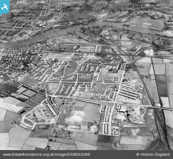
EAW010288 ENGLAND (1947). Development around Billy Mill and West Chirton, Billy Mill, from the north, 1947
    © Hawlfraint cyfranwyr OpenStreetMap a thrwyddedwyd gan yr OpenStreetMap Foundation. 2025. Trwyddedir y gartograffeg fel CC BY-SA.
  
Delweddau cyfagos (5)
Manylion
| Pennawd | [EAW010288] Development around Billy Mill and West Chirton, Billy Mill, from the north, 1947 | 
| Cyfeirnod | EAW010288 | 
| Dyddiad | 24-August-1947 | 
| Dolen | |
| Enw lle | BILLY MILL | 
| Plwyf | |
| Ardal | |
| Gwlad | ENGLAND | 
| Dwyreiniad / Gogleddiad | 433449, 569046 | 
| Hydred / Lledred | -1.4768570494966, 55.014768444404 | 
| Cyfeirnod Grid Cenedlaethol | NZ334690 | 
Pinnau
Byddwch y cyntaf i ychwanegu sylw at y ddelwedd hon!
 
             
  ![[EAW010288] Development around Billy Mill and West Chirton, Billy Mill, from the north, 1947](http://britainfromabove.org.uk/sites/all/libraries/aerofilms-images/public/100x100/EAW/010/EAW010288.jpg) 
  
                                          ![[EAW010287] Development around West Chirton and Billy Mill, West Chirton, from the north, 1947](http://britainfromabove.org.uk/sites/all/libraries/aerofilms-images/public/100x100/EAW/010/EAW010287.jpg) 
 ![[EAW010280] Development around West Chirton and Billy Mill, West Chirton, from the north, 1947](http://britainfromabove.org.uk/sites/all/libraries/aerofilms-images/public/100x100/EAW/010/EAW010280.jpg) 
 ![[EAW010294] Development around West Chirton and Billy Mill, West Chirton, from the north, 1947. This image was marked by Aerofilms Ltd for photo editing.](http://britainfromabove.org.uk/sites/all/libraries/aerofilms-images/public/100x100/EAW/010/EAW010294.jpg) 
 ![[EAW010286] Development around West Chirton and Billy Mill, West Chirton, from the north-east, 1947. This image was marked by Aerofilms Ltd for photo editing.](http://britainfromabove.org.uk/sites/all/libraries/aerofilms-images/public/100x100/EAW/010/EAW010286.jpg)