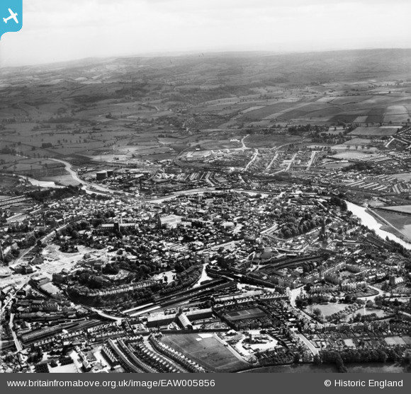
EAW005856 ENGLAND (1947). The city, Exeter, from the north, 1947
© Hawlfraint cyfranwyr OpenStreetMap a thrwyddedwyd gan yr OpenStreetMap Foundation. 2026. Trwyddedir y gartograffeg fel CC BY-SA.
Delweddau cyfagos (24)
Manylion
| Pennawd | [EAW005856] The city, Exeter, from the north, 1947 |
| Cyfeirnod | EAW005856 |
| Dyddiad | 18-May-1947 |
| Dolen | |
| Enw lle | EXETER |
| Plwyf | |
| Ardal | |
| Gwlad | ENGLAND |
| Dwyreiniad / Gogleddiad | 292030, 92774 |
| Hydred / Lledred | -3.5298250278616, 50.723972000985 |
| Cyfeirnod Grid Cenedlaethol | SX920928 |
Pinnau

Scooby |
Sunday 26th of September 2021 12:16:55 AM | |

Scooby |
Sunday 26th of September 2021 12:13:27 AM | |

SBEES |
Monday 29th of September 2014 12:37:55 PM | |

SBEES |
Monday 29th of September 2014 12:56:57 AM | |

SBEES |
Monday 29th of September 2014 12:47:05 AM | |

SBEES |
Sunday 28th of September 2014 11:51:41 PM | |

SBEES |
Sunday 28th of September 2014 11:43:28 PM | |

SBEES |
Sunday 28th of September 2014 11:23:05 PM | |

SBEES |
Sunday 28th of September 2014 11:20:56 PM | |

SBEES |
Sunday 28th of September 2014 11:11:28 PM | |

SBEES |
Sunday 28th of September 2014 11:08:21 PM | |

SBEES |
Sunday 28th of September 2014 10:57:06 PM | |

SBEES |
Sunday 28th of September 2014 10:54:23 PM | |

SBEES |
Sunday 28th of September 2014 10:23:08 PM | |

SBEES |
Sunday 28th of September 2014 10:06:29 PM | |

SBEES |
Sunday 28th of September 2014 10:05:06 PM | |

SBEES |
Sunday 28th of September 2014 07:29:30 PM | |

SBEES |
Sunday 28th of September 2014 07:28:10 PM | |
The church dated from 1867, and had been built as a replacement for the old minster church. See http://www.exetermemories.co.uk/em/_churches/stmarymajor.php for more information. |

John W |
Sunday 30th of October 2016 04:49:48 PM |

SBEES |
Sunday 28th of September 2014 06:55:56 PM | |

SBEES |
Sunday 28th of September 2014 05:39:24 PM | |

SBEES |
Sunday 28th of September 2014 04:37:34 PM | |

SBEES |
Sunday 28th of September 2014 04:32:10 PM | |

SBEES |
Sunday 28th of September 2014 04:25:51 PM | |

SBEES |
Sunday 28th of September 2014 04:24:15 PM | |

SBEES |
Sunday 28th of September 2014 04:04:29 PM | |

SBEES |
Sunday 28th of September 2014 04:03:41 PM | |

SBEES |
Sunday 28th of September 2014 04:02:33 PM | |

SBEES |
Sunday 28th of September 2014 04:00:08 PM | |

SBEES |
Sunday 28th of September 2014 03:52:27 PM | |

SBEES |
Sunday 28th of September 2014 03:46:07 PM | |

SBEES |
Sunday 28th of September 2014 03:37:33 PM | |

SBEES |
Sunday 28th of September 2014 02:56:22 PM | |

dawlishbob |
Sunday 3rd of August 2014 12:23:18 PM | |

Class31 |
Sunday 6th of July 2014 10:25:10 PM | |

gerry-r |
Sunday 6th of July 2014 10:11:14 PM | |
"Homes of British Speedway" describes this as a postwar construction but OS 1:2500 map dated 1932/36 shows Greyhound Stadium already on site. On the other hand OS 1:1250 map of 1950 shows development encroaching on south east corner, making book's assertion that dog racing continued until 1957 look unlikely. Trusham Road now runs through site. |

gBr |
Friday 16th of October 2015 04:31:37 PM |

Jon Primrose |
Tuesday 6th of May 2014 08:51:09 PM | |
Allen T |
Friday 8th of November 2013 05:01:00 PM | |
It's definitely on the line of the city wall - and if it was part of a blitzed building (the old post office?)it would surely have been knocked down by May 1947... |

Laura Maddison |
Monday 14th of July 2014 09:12:47 AM |
Allen T |
Friday 8th of November 2013 04:59:31 PM | |

Charles Dale |
Friday 8th of November 2013 04:53:57 PM | |

Charles Dale |
Friday 8th of November 2013 04:52:58 PM |


![[EAW005856] The city, Exeter, from the north, 1947](http://britainfromabove.org.uk/sites/all/libraries/aerofilms-images/public/100x100/EAW/005/EAW005856.jpg)
![[EAW051166] The city centre, Exeter, 1953](http://britainfromabove.org.uk/sites/all/libraries/aerofilms-images/public/100x100/EAW/051/EAW051166.jpg)
![[EAW003660] St Peter's Cathedral and the city centre, Exeter, 1930s](http://britainfromabove.org.uk/sites/all/libraries/aerofilms-images/public/100x100/EAW/003/EAW003660.jpg)
![[EPW003660] St Peter's Cathedral and the city centre, Exeter, 1930s](http://britainfromabove.org.uk/sites/all/libraries/aerofilms-images/public/100x100/EPW/003/EPW003660.jpg)
![[EAW005857] The city, Exeter, 1947](http://britainfromabove.org.uk/sites/all/libraries/aerofilms-images/public/100x100/EAW/005/EAW005857.jpg)
![[EAW051163] The city centre, Exeter, 1953](http://britainfromabove.org.uk/sites/all/libraries/aerofilms-images/public/100x100/EAW/051/EAW051163.jpg)
![[EAW051161] Exeter Castle, St Peter's Cathedral and the surrounding area, Exeter, 1953](http://britainfromabove.org.uk/sites/all/libraries/aerofilms-images/public/100x100/EAW/051/EAW051161.jpg)
![[EAW051162] St Peter's Cathedral and the city centre, Exeter, 1953](http://britainfromabove.org.uk/sites/all/libraries/aerofilms-images/public/100x100/EAW/051/EAW051162.jpg)
![[EAW003659] The city centre, Exeter, 1930s](http://britainfromabove.org.uk/sites/all/libraries/aerofilms-images/public/100x100/EAW/003/EAW003659.jpg)
![[EPW003659] The city centre, Exeter, 1930s](http://britainfromabove.org.uk/sites/all/libraries/aerofilms-images/public/100x100/EPW/003/EPW003659.jpg)
![[EAW005853] The city centre, Exeter, 1947](http://britainfromabove.org.uk/sites/all/libraries/aerofilms-images/public/100x100/EAW/005/EAW005853.jpg)
![[EPW003657] St Peter's Cathedral and the city centre, Exeter, 1930s](http://britainfromabove.org.uk/sites/all/libraries/aerofilms-images/public/100x100/EPW/003/EPW003657.jpg)
![[EAW051167] The city centre, Exeter, 1953](http://britainfromabove.org.uk/sites/all/libraries/aerofilms-images/public/100x100/EAW/051/EAW051167.jpg)
![[EAW051168] High Street, Bedford Street and the city centre, Exeter, 1953](http://britainfromabove.org.uk/sites/all/libraries/aerofilms-images/public/100x100/EAW/051/EAW051168.jpg)
![[EPW024104] Bedford Circus, Exeter, 1928](http://britainfromabove.org.uk/sites/all/libraries/aerofilms-images/public/100x100/EPW/024/EPW024104.jpg)
![[EAW005854] St Peter's Cathedral and the city centre, Exeter, 1947](http://britainfromabove.org.uk/sites/all/libraries/aerofilms-images/public/100x100/EAW/005/EAW005854.jpg)
![[EPW024108] St Peter's Cathedral, Exeter, 1928](http://britainfromabove.org.uk/sites/all/libraries/aerofilms-images/public/100x100/EPW/024/EPW024108.jpg)
![[EAW005852] St Peter's Cathedral, Exeter, 1947](http://britainfromabove.org.uk/sites/all/libraries/aerofilms-images/public/100x100/EAW/005/EAW005852.jpg)
![[EAW051172] The High Street and city centre, Exeter, 1953](http://britainfromabove.org.uk/sites/all/libraries/aerofilms-images/public/100x100/EAW/051/EAW051172.jpg)
![[EAW051165] The city centre, Exeter, 1953](http://britainfromabove.org.uk/sites/all/libraries/aerofilms-images/public/100x100/EAW/051/EAW051165.jpg)
![[EPW041169] Exeter Cathedral, Exeter, 1933](http://britainfromabove.org.uk/sites/all/libraries/aerofilms-images/public/100x100/EPW/041/EPW041169.jpg)
![[EPW024105] St Peter's Cathedral, Exeter, 1928](http://britainfromabove.org.uk/sites/all/libraries/aerofilms-images/public/100x100/EPW/024/EPW024105.jpg)
![[EPW024083] St Peter's Cathedral, Exeter, 1928](http://britainfromabove.org.uk/sites/all/libraries/aerofilms-images/public/100x100/EPW/024/EPW024083.jpg)
![[EAW051169] The site of Bedford Circus and the city centre, Exeter, 1953](http://britainfromabove.org.uk/sites/all/libraries/aerofilms-images/public/100x100/EAW/051/EAW051169.jpg)
