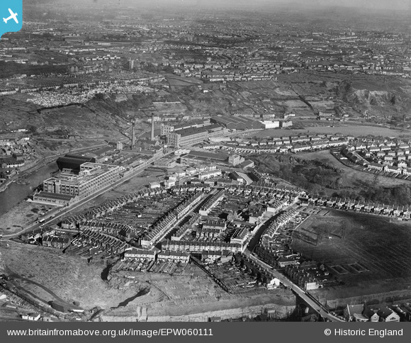
EPW060111 ENGLAND (1938). The St Anne's Board Mill Co Ltd Works and the surrounding residential area, Bristol, 1938
© Copyright OpenStreetMap contributors and licensed by the OpenStreetMap Foundation. 2026. Cartography is licensed as CC BY-SA.
Nearby Images (27)
Details
| Title | [EPW060111] The St Anne's Board Mill Co Ltd Works and the surrounding residential area, Bristol, 1938 |
| Reference | EPW060111 |
| Date | 1-November-1938 |
| Link | |
| Place name | BRISTOL |
| Parish | |
| District | |
| Country | ENGLAND |
| Easting / Northing | 362111, 172800 |
| Longitude / Latitude | -2.5453374314319, 51.452424629926 |
| National Grid Reference | ST621728 |
Pins
Be the first to add a comment to this image!


![[EPW060111] The St Anne's Board Mill Co Ltd Works and the surrounding residential area, Bristol, 1938](http://britainfromabove.org.uk/sites/all/libraries/aerofilms-images/public/100x100/EPW/060/EPW060111.jpg)
![[EPW060112] The St Anne's Board Mill Co Ltd Works, Bristol, 1938](http://britainfromabove.org.uk/sites/all/libraries/aerofilms-images/public/100x100/EPW/060/EPW060112.jpg)
![[EPW050565] St Anne's Board Mill Co Ltd Works, Bristol, 1936](http://britainfromabove.org.uk/sites/all/libraries/aerofilms-images/public/100x100/EPW/050/EPW050565.jpg)
![[EPW060113] The St Anne's Board Mill Co Ltd Works and the surrounding residential area, Bristol, 1938](http://britainfromabove.org.uk/sites/all/libraries/aerofilms-images/public/100x100/EPW/060/EPW060113.jpg)
![[EPW050465] St Anne's Board Mill Co Ltd Works and environs, Bristol, 1936](http://britainfromabove.org.uk/sites/all/libraries/aerofilms-images/public/100x100/EPW/050/EPW050465.jpg)
![[EPW050571] St Anne's Board Mill Co Ltd Works, Bristol, 1936](http://britainfromabove.org.uk/sites/all/libraries/aerofilms-images/public/100x100/EPW/050/EPW050571.jpg)
![[EPW060114] The St Anne's Board Mill Co Ltd Works and the surrounding residential area, Bristol, 1938](http://britainfromabove.org.uk/sites/all/libraries/aerofilms-images/public/100x100/EPW/060/EPW060114.jpg)
![[EPW060105] The St Anne's Board Mill Co Ltd Works and the surrounding residential area, Bristol, 1938](http://britainfromabove.org.uk/sites/all/libraries/aerofilms-images/public/100x100/EPW/060/EPW060105.jpg)
![[EPW050468] St Anne's Board Mill Co Ltd Works, Newbridge Road and environs, Bristol, 1936](http://britainfromabove.org.uk/sites/all/libraries/aerofilms-images/public/100x100/EPW/050/EPW050468.jpg)
![[EPW060106] The St Anne's Board Mill Co Ltd Works, Bristol, 1938](http://britainfromabove.org.uk/sites/all/libraries/aerofilms-images/public/100x100/EPW/060/EPW060106.jpg)
![[EPW060109] The St Anne's Board Mill Co Ltd Works and the surrounding residential area, Bristol, 1938](http://britainfromabove.org.uk/sites/all/libraries/aerofilms-images/public/100x100/EPW/060/EPW060109.jpg)
![[EPW050469] St Anne's Board Mill Co Ltd Works, Newbridge Road and environs, Bristol, 1936](http://britainfromabove.org.uk/sites/all/libraries/aerofilms-images/public/100x100/EPW/050/EPW050469.jpg)
![[EPW050566] St Anne's Board Mill Co Ltd Works, Bristol, 1936](http://britainfromabove.org.uk/sites/all/libraries/aerofilms-images/public/100x100/EPW/050/EPW050566.jpg)
![[EPW005538] St Anne's Board Mill Co Ltd Works, Bristol, 1921](http://britainfromabove.org.uk/sites/all/libraries/aerofilms-images/public/100x100/EPW/005/EPW005538.jpg)
![[EPW050567] St Anne's Board Mill Co Ltd Works, Bristol, 1936](http://britainfromabove.org.uk/sites/all/libraries/aerofilms-images/public/100x100/EPW/050/EPW050567.jpg)
![[EPW050561] St Anne's Board Mill Co Ltd Works, Bristol, 1936](http://britainfromabove.org.uk/sites/all/libraries/aerofilms-images/public/100x100/EPW/050/EPW050561.jpg)
![[EPW050562] St Anne's Board Mill Co Ltd Works and environs, Bristol, 1936](http://britainfromabove.org.uk/sites/all/libraries/aerofilms-images/public/100x100/EPW/050/EPW050562.jpg)
![[EPW050570] St Anne's Board Mill Co Ltd Works, Bristol, 1936](http://britainfromabove.org.uk/sites/all/libraries/aerofilms-images/public/100x100/EPW/050/EPW050570.jpg)
![[EPW060110] The St Anne's Board Mill Co Ltd Works and the surrounding residential area, Bristol, 1938](http://britainfromabove.org.uk/sites/all/libraries/aerofilms-images/public/100x100/EPW/060/EPW060110.jpg)
![[EPW060115] The St Anne's Board Mill Co Ltd Works, Bristol, 1938](http://britainfromabove.org.uk/sites/all/libraries/aerofilms-images/public/100x100/EPW/060/EPW060115.jpg)
![[EPW050470] St Anne's Board Mill Co Ltd Works and environs, Bristol, 1936](http://britainfromabove.org.uk/sites/all/libraries/aerofilms-images/public/100x100/EPW/050/EPW050470.jpg)
![[EPW050557] St Anne's Board Mill Co Ltd Works and Wootton Road, Bristol, 1936](http://britainfromabove.org.uk/sites/all/libraries/aerofilms-images/public/100x100/EPW/050/EPW050557.jpg)
![[EPW050559] St Anne's Board Mill Co Ltd Works, Bristol, 1936](http://britainfromabove.org.uk/sites/all/libraries/aerofilms-images/public/100x100/EPW/050/EPW050559.jpg)
![[EPW050572] St Anne's Board Mill Co Ltd Works, Bristol, 1936](http://britainfromabove.org.uk/sites/all/libraries/aerofilms-images/public/100x100/EPW/050/EPW050572.jpg)
![[EPW060107] The St Anne's Board Mill Co Ltd Works, Bristol, 1938](http://britainfromabove.org.uk/sites/all/libraries/aerofilms-images/public/100x100/EPW/060/EPW060107.jpg)
![[EPW050464] Housing at St Anne's Park and the St Anne's Board Mill Co Ltd Works, Bristol, 1936](http://britainfromabove.org.uk/sites/all/libraries/aerofilms-images/public/100x100/EPW/050/EPW050464.jpg)
![[EPW050569] Part of St Anne's Board Mill Co Ltd Works, Bristol, 1936](http://britainfromabove.org.uk/sites/all/libraries/aerofilms-images/public/100x100/EPW/050/EPW050569.jpg)