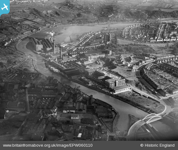
EPW060110 ENGLAND (1938). The St Anne's Board Mill Co Ltd Works and the surrounding residential area, Bristol, 1938
© Copyright OpenStreetMap contributors and licensed by the OpenStreetMap Foundation. 2026. Cartography is licensed as CC BY-SA.
Nearby Images (22)
Details
| Title | [EPW060110] The St Anne's Board Mill Co Ltd Works and the surrounding residential area, Bristol, 1938 |
| Reference | EPW060110 |
| Date | 1-November-1938 |
| Link | |
| Place name | BRISTOL |
| Parish | |
| District | |
| Country | ENGLAND |
| Easting / Northing | 361902, 172805 |
| Longitude / Latitude | -2.5483459651899, 51.452455561981 |
| National Grid Reference | ST619728 |
Pins

Class31 |
Monday 11th of May 2015 07:23:58 AM | |

Class31 |
Monday 11th of May 2015 07:06:48 AM | |

Class31 |
Monday 11th of May 2015 07:06:12 AM | |

duke |
Monday 4th of November 2013 08:23:19 PM | |
That's a fascinating collection of historical facts. Thanks for posting! I grew up on Newbridge Road so it's good to know a bit more about my roots :-) |

kellysheppard510@ymail.com |
Thursday 19th of November 2015 12:02:10 PM |
User Comment Contributions
I lived at Wootton Crescent when I was a child. It can be seen clearly on the photo. In fact I can see our house which mum still lives in. If you look at the chimney on the right, you can make out Wootton Road going up with the circle on the left. That was the water plant and it had a bridge across it which rotated all the time. We could see it from our front room window. |

Pennyjames |
Monday 4th of April 2016 05:31:21 PM |
View south from Troopers Hill Local Nature Reserve, St. Georges, Bristol, 10/05/2015 |

Class31 |
Monday 11th of May 2015 07:25:27 AM |


![[EPW060110] The St Anne's Board Mill Co Ltd Works and the surrounding residential area, Bristol, 1938](http://britainfromabove.org.uk/sites/all/libraries/aerofilms-images/public/100x100/EPW/060/EPW060110.jpg)
![[EPW050561] St Anne's Board Mill Co Ltd Works, Bristol, 1936](http://britainfromabove.org.uk/sites/all/libraries/aerofilms-images/public/100x100/EPW/050/EPW050561.jpg)
![[EPW050566] St Anne's Board Mill Co Ltd Works, Bristol, 1936](http://britainfromabove.org.uk/sites/all/libraries/aerofilms-images/public/100x100/EPW/050/EPW050566.jpg)
![[EPW050567] St Anne's Board Mill Co Ltd Works, Bristol, 1936](http://britainfromabove.org.uk/sites/all/libraries/aerofilms-images/public/100x100/EPW/050/EPW050567.jpg)
![[EPW050559] St Anne's Board Mill Co Ltd Works, Bristol, 1936](http://britainfromabove.org.uk/sites/all/libraries/aerofilms-images/public/100x100/EPW/050/EPW050559.jpg)
![[EPW005538] St Anne's Board Mill Co Ltd Works, Bristol, 1921](http://britainfromabove.org.uk/sites/all/libraries/aerofilms-images/public/100x100/EPW/005/EPW005538.jpg)
![[EPW050470] St Anne's Board Mill Co Ltd Works and environs, Bristol, 1936](http://britainfromabove.org.uk/sites/all/libraries/aerofilms-images/public/100x100/EPW/050/EPW050470.jpg)
![[EPW050572] St Anne's Board Mill Co Ltd Works, Bristol, 1936](http://britainfromabove.org.uk/sites/all/libraries/aerofilms-images/public/100x100/EPW/050/EPW050572.jpg)
![[EPW060105] The St Anne's Board Mill Co Ltd Works and the surrounding residential area, Bristol, 1938](http://britainfromabove.org.uk/sites/all/libraries/aerofilms-images/public/100x100/EPW/060/EPW060105.jpg)
![[EPW060109] The St Anne's Board Mill Co Ltd Works and the surrounding residential area, Bristol, 1938](http://britainfromabove.org.uk/sites/all/libraries/aerofilms-images/public/100x100/EPW/060/EPW060109.jpg)
![[EPW060114] The St Anne's Board Mill Co Ltd Works and the surrounding residential area, Bristol, 1938](http://britainfromabove.org.uk/sites/all/libraries/aerofilms-images/public/100x100/EPW/060/EPW060114.jpg)
![[EPW050564] Part of St Anne's Board Mill Co Ltd Works and Newbridge Road, Bristol, 1936](http://britainfromabove.org.uk/sites/all/libraries/aerofilms-images/public/100x100/EPW/050/EPW050564.jpg)
![[EPW060113] The St Anne's Board Mill Co Ltd Works and the surrounding residential area, Bristol, 1938](http://britainfromabove.org.uk/sites/all/libraries/aerofilms-images/public/100x100/EPW/060/EPW060113.jpg)
![[EPW050468] St Anne's Board Mill Co Ltd Works, Newbridge Road and environs, Bristol, 1936](http://britainfromabove.org.uk/sites/all/libraries/aerofilms-images/public/100x100/EPW/050/EPW050468.jpg)
![[EPW060111] The St Anne's Board Mill Co Ltd Works and the surrounding residential area, Bristol, 1938](http://britainfromabove.org.uk/sites/all/libraries/aerofilms-images/public/100x100/EPW/060/EPW060111.jpg)
![[EPW050565] St Anne's Board Mill Co Ltd Works, Bristol, 1936](http://britainfromabove.org.uk/sites/all/libraries/aerofilms-images/public/100x100/EPW/050/EPW050565.jpg)
![[EPW050469] St Anne's Board Mill Co Ltd Works, Newbridge Road and environs, Bristol, 1936](http://britainfromabove.org.uk/sites/all/libraries/aerofilms-images/public/100x100/EPW/050/EPW050469.jpg)
![[EPW060112] The St Anne's Board Mill Co Ltd Works, Bristol, 1938](http://britainfromabove.org.uk/sites/all/libraries/aerofilms-images/public/100x100/EPW/060/EPW060112.jpg)
![[EPW050562] St Anne's Board Mill Co Ltd Works and environs, Bristol, 1936](http://britainfromabove.org.uk/sites/all/libraries/aerofilms-images/public/100x100/EPW/050/EPW050562.jpg)
![[EPW050571] St Anne's Board Mill Co Ltd Works, Bristol, 1936](http://britainfromabove.org.uk/sites/all/libraries/aerofilms-images/public/100x100/EPW/050/EPW050571.jpg)
![[EPW050465] St Anne's Board Mill Co Ltd Works and environs, Bristol, 1936](http://britainfromabove.org.uk/sites/all/libraries/aerofilms-images/public/100x100/EPW/050/EPW050465.jpg)
![[EPW060106] The St Anne's Board Mill Co Ltd Works, Bristol, 1938](http://britainfromabove.org.uk/sites/all/libraries/aerofilms-images/public/100x100/EPW/060/EPW060106.jpg)