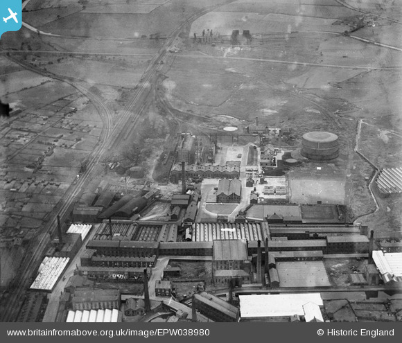
EPW038980 ENGLAND (1932). Great Harwood Junction and the Greenbank Gas Works, Blackburn, 1932
© Copyright OpenStreetMap contributors and licensed by the OpenStreetMap Foundation. 2025. Cartography is licensed as CC BY-SA.
Nearby Images (23)
Details
| Title | [EPW038980] Great Harwood Junction and the Greenbank Gas Works, Blackburn, 1932 |
| Reference | EPW038980 |
| Date | July-1932 |
| Link | |
| Place name | BLACKBURN |
| Parish | |
| District | |
| Country | ENGLAND |
| Easting / Northing | 369903, 428903 |
| Longitude / Latitude | -2.4565226033911, 53.755399608006 |
| National Grid Reference | SD699289 |
Pins

Roger |
Friday 25th of October 2024 08:44:38 PM | |

beast66606 |
Thursday 10th of October 2013 10:27:54 PM |


![[EPW038980] Great Harwood Junction and the Greenbank Gas Works, Blackburn, 1932](http://britainfromabove.org.uk/sites/all/libraries/aerofilms-images/public/100x100/EPW/038/EPW038980.jpg)
![[EPW038983] Greenbank Gas Works, Imperial Cotton Mills and environs, Blackburn, 1932](http://britainfromabove.org.uk/sites/all/libraries/aerofilms-images/public/100x100/EPW/038/EPW038983.jpg)
![[EPW038981] Greenbank Gas Works and environs, Blackburn, 1932](http://britainfromabove.org.uk/sites/all/libraries/aerofilms-images/public/100x100/EPW/038/EPW038981.jpg)
![[EPW038982] Great Harwood Junction, the Greenbank Gas Works and environs, Blackburn, 1932](http://britainfromabove.org.uk/sites/all/libraries/aerofilms-images/public/100x100/EPW/038/EPW038982.jpg)
![[EAW025529] The Northrop Loom Works and environs, Blackburn, 1949. This image has been produced from a print marked by Aerofilms Ltd for photo editing.](http://britainfromabove.org.uk/sites/all/libraries/aerofilms-images/public/100x100/EAW/025/EAW025529.jpg)
![[EAW025532] The Northrop Loom Works and environs, Blackburn, 1949. This image has been produced from a print marked by Aerofilms Ltd for photo editing.](http://britainfromabove.org.uk/sites/all/libraries/aerofilms-images/public/100x100/EAW/025/EAW025532.jpg)
![[EPW038979] Greenbank Gas Works, Blackburn, 1932](http://britainfromabove.org.uk/sites/all/libraries/aerofilms-images/public/100x100/EPW/038/EPW038979.jpg)
![[EAW025530] The Northrop Loom Works and environs, Blackburn, 1949. This image has been produced from a print marked by Aerofilms Ltd for photo editing.](http://britainfromabove.org.uk/sites/all/libraries/aerofilms-images/public/100x100/EAW/025/EAW025530.jpg)
![[EAW025531] The Northrop Loom Works and environs, Blackburn, 1949. This image has been produced from a print marked by Aerofilms Ltd for photo editing.](http://britainfromabove.org.uk/sites/all/libraries/aerofilms-images/public/100x100/EAW/025/EAW025531.jpg)
![[EAW025537] The Northrop Loom Works, Blackburn, 1949. This image has been produced from a damaged negative.](http://britainfromabove.org.uk/sites/all/libraries/aerofilms-images/public/100x100/EAW/025/EAW025537.jpg)
![[EAW025527] The Northrop Loom Works and environs, Blackburn, 1949. This image has been produced from a print marked by Aerofilms Ltd for photo editing.](http://britainfromabove.org.uk/sites/all/libraries/aerofilms-images/public/100x100/EAW/025/EAW025527.jpg)
![[EAW025536] The Northrop Loom Works and Great Harwood Junction, Blackburn, 1949. This image has been produced from a damaged negative.](http://britainfromabove.org.uk/sites/all/libraries/aerofilms-images/public/100x100/EAW/025/EAW025536.jpg)
![[EAW025538] The Northrop Loom Works, Blackburn, 1949. This image has been produced from a damaged negative.](http://britainfromabove.org.uk/sites/all/libraries/aerofilms-images/public/100x100/EAW/025/EAW025538.jpg)
![[EAW033861] Alston Mill, Little Harwood, 1950. This image was marked by Aerofilms Ltd for photo editing.](http://britainfromabove.org.uk/sites/all/libraries/aerofilms-images/public/100x100/EAW/033/EAW033861.jpg)
![[EAW033866] Alston Mill, Little Harwood, 1950. This image was marked by Aerofilms Ltd for photo editing.](http://britainfromabove.org.uk/sites/all/libraries/aerofilms-images/public/100x100/EAW/033/EAW033866.jpg)
![[EAW033860] Alston Mill, Little Harwood, 1950. This image was marked by Aerofilms Ltd for photo editing.](http://britainfromabove.org.uk/sites/all/libraries/aerofilms-images/public/100x100/EAW/033/EAW033860.jpg)
![[EAW033859] Alston Mill, Little Harwood, 1950. This image was marked by Aerofilms Ltd for photo editing.](http://britainfromabove.org.uk/sites/all/libraries/aerofilms-images/public/100x100/EAW/033/EAW033859.jpg)
![[EAW033862] Alston Mill, Little Harwood, 1950. This image was marked by Aerofilms Ltd for photo editing.](http://britainfromabove.org.uk/sites/all/libraries/aerofilms-images/public/100x100/EAW/033/EAW033862.jpg)
![[EAW033865] Alston Mill, Little Harwood, 1950. This image was marked by Aerofilms Ltd for photo editing.](http://britainfromabove.org.uk/sites/all/libraries/aerofilms-images/public/100x100/EAW/033/EAW033865.jpg)
![[EAW033863] Alston Mill, Little Harwood, 1950. This image was marked by Aerofilms Ltd for photo editing.](http://britainfromabove.org.uk/sites/all/libraries/aerofilms-images/public/100x100/EAW/033/EAW033863.jpg)
![[EAW033864] Alston Mill, Little Harwood, 1950. This image was marked by Aerofilms Ltd for photo editing.](http://britainfromabove.org.uk/sites/all/libraries/aerofilms-images/public/100x100/EAW/033/EAW033864.jpg)
![[EAW025534] The Northrop Loom Works, Blackburn, from the north-west, 1949. This image has been produced from a damaged negative.](http://britainfromabove.org.uk/sites/all/libraries/aerofilms-images/public/100x100/EAW/025/EAW025534.jpg)
![[EAW025539] The Northrop Loom Works, Blackburn, from the west, 1949. This image has been produced from a damaged negative.](http://britainfromabove.org.uk/sites/all/libraries/aerofilms-images/public/100x100/EAW/025/EAW025539.jpg)