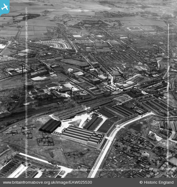
EAW025530 ENGLAND (1949). The Northrop Loom Works and environs, Blackburn, 1949. This image has been produced from a print marked by Aerofilms Ltd for photo editing.
© Copyright OpenStreetMap contributors and licensed by the OpenStreetMap Foundation. 2025. Cartography is licensed as CC BY-SA.
Nearby Images (17)
Details
| Title | [EAW025530] The Northrop Loom Works and environs, Blackburn, 1949. This image has been produced from a print marked by Aerofilms Ltd for photo editing. |
| Reference | EAW025530 |
| Date | 3-August-1949 |
| Link | |
| Place name | BLACKBURN |
| Parish | |
| District | |
| Country | ENGLAND |
| Easting / Northing | 369749, 428814 |
| Longitude / Latitude | -2.4588497318653, 53.754590687407 |
| National Grid Reference | SD697288 |
Pins
Be the first to add a comment to this image!


![[EAW025530] The Northrop Loom Works and environs, Blackburn, 1949. This image has been produced from a print marked by Aerofilms Ltd for photo editing.](http://britainfromabove.org.uk/sites/all/libraries/aerofilms-images/public/100x100/EAW/025/EAW025530.jpg)
![[EAW025531] The Northrop Loom Works and environs, Blackburn, 1949. This image has been produced from a print marked by Aerofilms Ltd for photo editing.](http://britainfromabove.org.uk/sites/all/libraries/aerofilms-images/public/100x100/EAW/025/EAW025531.jpg)
![[EAW025529] The Northrop Loom Works and environs, Blackburn, 1949. This image has been produced from a print marked by Aerofilms Ltd for photo editing.](http://britainfromabove.org.uk/sites/all/libraries/aerofilms-images/public/100x100/EAW/025/EAW025529.jpg)
![[EAW033861] Alston Mill, Little Harwood, 1950. This image was marked by Aerofilms Ltd for photo editing.](http://britainfromabove.org.uk/sites/all/libraries/aerofilms-images/public/100x100/EAW/033/EAW033861.jpg)
![[EAW033860] Alston Mill, Little Harwood, 1950. This image was marked by Aerofilms Ltd for photo editing.](http://britainfromabove.org.uk/sites/all/libraries/aerofilms-images/public/100x100/EAW/033/EAW033860.jpg)
![[EAW033866] Alston Mill, Little Harwood, 1950. This image was marked by Aerofilms Ltd for photo editing.](http://britainfromabove.org.uk/sites/all/libraries/aerofilms-images/public/100x100/EAW/033/EAW033866.jpg)
![[EAW033862] Alston Mill, Little Harwood, 1950. This image was marked by Aerofilms Ltd for photo editing.](http://britainfromabove.org.uk/sites/all/libraries/aerofilms-images/public/100x100/EAW/033/EAW033862.jpg)
![[EAW033865] Alston Mill, Little Harwood, 1950. This image was marked by Aerofilms Ltd for photo editing.](http://britainfromabove.org.uk/sites/all/libraries/aerofilms-images/public/100x100/EAW/033/EAW033865.jpg)
![[EAW033859] Alston Mill, Little Harwood, 1950. This image was marked by Aerofilms Ltd for photo editing.](http://britainfromabove.org.uk/sites/all/libraries/aerofilms-images/public/100x100/EAW/033/EAW033859.jpg)
![[EAW033863] Alston Mill, Little Harwood, 1950. This image was marked by Aerofilms Ltd for photo editing.](http://britainfromabove.org.uk/sites/all/libraries/aerofilms-images/public/100x100/EAW/033/EAW033863.jpg)
![[EAW033864] Alston Mill, Little Harwood, 1950. This image was marked by Aerofilms Ltd for photo editing.](http://britainfromabove.org.uk/sites/all/libraries/aerofilms-images/public/100x100/EAW/033/EAW033864.jpg)
![[EPW038983] Greenbank Gas Works, Imperial Cotton Mills and environs, Blackburn, 1932](http://britainfromabove.org.uk/sites/all/libraries/aerofilms-images/public/100x100/EPW/038/EPW038983.jpg)
![[EPW038980] Great Harwood Junction and the Greenbank Gas Works, Blackburn, 1932](http://britainfromabove.org.uk/sites/all/libraries/aerofilms-images/public/100x100/EPW/038/EPW038980.jpg)
![[EAW025532] The Northrop Loom Works and environs, Blackburn, 1949. This image has been produced from a print marked by Aerofilms Ltd for photo editing.](http://britainfromabove.org.uk/sites/all/libraries/aerofilms-images/public/100x100/EAW/025/EAW025532.jpg)
![[EAW025537] The Northrop Loom Works, Blackburn, 1949. This image has been produced from a damaged negative.](http://britainfromabove.org.uk/sites/all/libraries/aerofilms-images/public/100x100/EAW/025/EAW025537.jpg)
![[EPW038981] Greenbank Gas Works and environs, Blackburn, 1932](http://britainfromabove.org.uk/sites/all/libraries/aerofilms-images/public/100x100/EPW/038/EPW038981.jpg)
![[EPW038982] Great Harwood Junction, the Greenbank Gas Works and environs, Blackburn, 1932](http://britainfromabove.org.uk/sites/all/libraries/aerofilms-images/public/100x100/EPW/038/EPW038982.jpg)