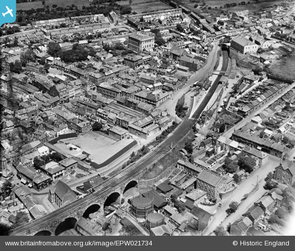
EPW021734 ENGLAND (1928). The railway station and the town, Redruth, 1928
© Copyright OpenStreetMap contributors and licensed by the OpenStreetMap Foundation. 2026. Cartography is licensed as CC BY-SA.
Nearby Images (16)
Details
| Title | [EPW021734] The railway station and the town, Redruth, 1928 |
| Reference | EPW021734 |
| Date | 24-June-1928 |
| Link | |
| Place name | REDRUTH |
| Parish | REDRUTH |
| District | |
| Country | ENGLAND |
| Easting / Northing | 169954, 41953 |
| Longitude / Latitude | -5.226099979164, 50.232125378804 |
| National Grid Reference | SW700420 |
Pins

NTkris |
Wednesday 19th of January 2022 05:59:43 PM | |

Pentaprism |
Saturday 31st of October 2020 02:06:29 AM | |

Stu |
Sunday 27th of January 2013 12:45:47 AM | |

MB |
Tuesday 11th of September 2012 10:30:52 AM | |

MB |
Tuesday 11th of September 2012 10:27:29 AM | |

MB |
Tuesday 11th of September 2012 09:53:33 AM | |

MB |
Tuesday 11th of September 2012 09:50:55 AM | |

MB |
Tuesday 11th of September 2012 09:49:27 AM | |

MB |
Tuesday 11th of September 2012 09:48:13 AM | |

Allan |
Monday 30th of July 2012 04:39:17 PM |
User Comment Contributions

Alexander Seal |
Friday 6th of July 2012 07:08:30 PM |


![[EPW021734] The railway station and the town, Redruth, 1928](http://britainfromabove.org.uk/sites/all/libraries/aerofilms-images/public/100x100/EPW/021/EPW021734.jpg)
![[EPW009905] The town centre, Redruth, 1924](http://britainfromabove.org.uk/sites/all/libraries/aerofilms-images/public/100x100/EPW/009/EPW009905.jpg)
![[EPW009902] The town centre, Redruth, 1924](http://britainfromabove.org.uk/sites/all/libraries/aerofilms-images/public/100x100/EPW/009/EPW009902.jpg)
![[EAW033649] The town, Redruth, 1950](http://britainfromabove.org.uk/sites/all/libraries/aerofilms-images/public/100x100/EAW/033/EAW033649.jpg)
![[EPW021731] The railway station and environs, Redruth, 1928](http://britainfromabove.org.uk/sites/all/libraries/aerofilms-images/public/100x100/EPW/021/EPW021731.jpg)
![[EAW033647] West End, Fore Street and the town centre, Redruth, 1950](http://britainfromabove.org.uk/sites/all/libraries/aerofilms-images/public/100x100/EAW/033/EAW033647.jpg)
![[EPW009904] The town centre, Redruth, 1924](http://britainfromabove.org.uk/sites/all/libraries/aerofilms-images/public/100x100/EPW/009/EPW009904.jpg)
![[EPW039787] Victoria Park, Raymond Road and the town, Redruth, 1932](http://britainfromabove.org.uk/sites/all/libraries/aerofilms-images/public/100x100/EPW/039/EPW039787.jpg)
![[EPW021730] The Free United Methodist Church and environs, Redruth, 1928](http://britainfromabove.org.uk/sites/all/libraries/aerofilms-images/public/100x100/EPW/021/EPW021730.jpg)
![[EPW021733] Fore Street and the town, Redruth, 1928](http://britainfromabove.org.uk/sites/all/libraries/aerofilms-images/public/100x100/EPW/021/EPW021733.jpg)
![[EPW039788] Falmouth Road, Clinton Road and the Viaduct, Redruth, 1932](http://britainfromabove.org.uk/sites/all/libraries/aerofilms-images/public/100x100/EPW/039/EPW039788.jpg)
![[EPW009903] Penryn Street and environs, Redruth, 1924](http://britainfromabove.org.uk/sites/all/libraries/aerofilms-images/public/100x100/EPW/009/EPW009903.jpg)
![[EPW009904A] The town centre, Redruth, 1924](http://britainfromabove.org.uk/sites/all/libraries/aerofilms-images/public/100x100/EPW/009/EPW009904A.jpg)
![[EPW021732] Fore Street and the town, Redruth, 1928](http://britainfromabove.org.uk/sites/all/libraries/aerofilms-images/public/100x100/EPW/021/EPW021732.jpg)
![[EPW039786] The town, Redruth, 1932](http://britainfromabove.org.uk/sites/all/libraries/aerofilms-images/public/100x100/EPW/039/EPW039786.jpg)
![[EPW009901] Clinton Road and environs, Redruth, 1924](http://britainfromabove.org.uk/sites/all/libraries/aerofilms-images/public/100x100/EPW/009/EPW009901.jpg)
