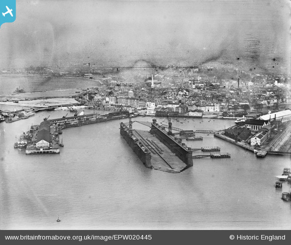
EPW020445 ENGLAND (1928). Floating Dock, Southampton, from the south, 1928
© Copyright OpenStreetMap contributors and licensed by the OpenStreetMap Foundation. 2026. Cartography is licensed as CC BY-SA.
Nearby Images (25)
Details
| Title | [EPW020445] Floating Dock, Southampton, from the south, 1928 |
| Reference | EPW020445 |
| Date | 16-March-1928 |
| Link | |
| Place name | SOUTHAMPTON |
| Parish | |
| District | |
| Country | ENGLAND |
| Easting / Northing | 442046, 110438 |
| Longitude / Latitude | -1.40213034637, 50.891339810354 |
| National Grid Reference | SU420104 |
Pins

ARussel |
Saturday 18th of September 2021 10:16:31 PM | |

ARussel |
Saturday 18th of September 2021 10:10:22 PM | |

Class31 |
Saturday 31st of May 2014 08:11:13 AM | |

J Goodacre |
Sunday 21st of October 2012 10:53:28 PM | |

MB |
Sunday 14th of October 2012 10:16:58 PM | |

MB |
Sunday 14th of October 2012 10:15:48 PM | |

Marc |
Monday 9th of July 2012 05:16:20 PM |


![[EPW020445] Floating Dock, Southampton, from the south, 1928](http://britainfromabove.org.uk/sites/all/libraries/aerofilms-images/public/100x100/EPW/020/EPW020445.jpg)
![[EAW001355] The Docks, Southampton, from the south-east, 1946](http://britainfromabove.org.uk/sites/all/libraries/aerofilms-images/public/100x100/EAW/001/EAW001355.jpg)
![[EPW041072] The RMS Mauretania in the floating dry dock, Southampton, from the south, 1933](http://britainfromabove.org.uk/sites/all/libraries/aerofilms-images/public/100x100/EPW/041/EPW041072.jpg)
![[EPW037430] Ocean Liners in Southampton Docks, Southampton, 1932. This image has been produced from a copy-negative affected by flare.](http://britainfromabove.org.uk/sites/all/libraries/aerofilms-images/public/100x100/EPW/037/EPW037430.jpg)
![[EPW041073] The RMS Mauretania in the floating dry dock, Southampton, 1933](http://britainfromabove.org.uk/sites/all/libraries/aerofilms-images/public/100x100/EPW/041/EPW041073.jpg)
![[EAW008810] The docks, Southampton, from the south-west, 1947](http://britainfromabove.org.uk/sites/all/libraries/aerofilms-images/public/100x100/EAW/008/EAW008810.jpg)
![[EPW020452] Floating Dock, Southampton, 1928](http://britainfromabove.org.uk/sites/all/libraries/aerofilms-images/public/100x100/EPW/020/EPW020452.jpg)
![[EAW001361] The Docks, Southampton, 1946](http://britainfromabove.org.uk/sites/all/libraries/aerofilms-images/public/100x100/EAW/001/EAW001361.jpg)
![[EAW001358] The Docks, Southampton, 1946](http://britainfromabove.org.uk/sites/all/libraries/aerofilms-images/public/100x100/EAW/001/EAW001358.jpg)
![[EAW015268] RMS Queen Elizabeth berthed at Ocean Dock, Southampton, 1948](http://britainfromabove.org.uk/sites/all/libraries/aerofilms-images/public/100x100/EAW/015/EAW015268.jpg)
![[EPW041039] The National Aviation Day air display team (G-ABUC, G-ACCX, G-ABUL, G-ABYX, G-ACEY, G-ABYH and G-ABVH) formation flying over Kingswood, Sanderstead, from the east, 1933](http://britainfromabove.org.uk/sites/all/libraries/aerofilms-images/public/100x100/EPW/041/EPW041039.jpg)
![[EPW041069] Ocean Dock, the RMS Olympic, RMS Mauretania in the floating dry dock and environs, Southampton, from the west, 1933](http://britainfromabove.org.uk/sites/all/libraries/aerofilms-images/public/100x100/EPW/041/EPW041069.jpg)
![[EPW000238] Vessels on Southampton Water, Southampton, 1920](http://britainfromabove.org.uk/sites/all/libraries/aerofilms-images/public/100x100/EPW/000/EPW000238.jpg)
![[EAW008812] The docks, Southampton, from the west, 1947](http://britainfromabove.org.uk/sites/all/libraries/aerofilms-images/public/100x100/EAW/008/EAW008812.jpg)
![[EAW020647] The British Overseas Airways Corporation (BOAC) Marine Airport and the surrounding docks, Southampton, 1948](http://britainfromabove.org.uk/sites/all/libraries/aerofilms-images/public/100x100/EAW/020/EAW020647.jpg)
![[EAW020645] The British Overseas Airways Corporation (BOAC) Marine Airport and the surrounding docks, Southampton, 1948](http://britainfromabove.org.uk/sites/all/libraries/aerofilms-images/public/100x100/EAW/020/EAW020645.jpg)
![[EAW020646] The British Overseas Airways Corporation (BOAC) Marine Airport and the surrounding docks, Southampton, 1948](http://britainfromabove.org.uk/sites/all/libraries/aerofilms-images/public/100x100/EAW/020/EAW020646.jpg)
![[EAW189228] Southampton Docks, Southampton, 1968](http://britainfromabove.org.uk/sites/all/libraries/aerofilms-images/public/100x100/EAW/189/EAW189228.jpg)
![[EPW041070] The RMS Olympic and environs, Southampton, from the west, 1933](http://britainfromabove.org.uk/sites/all/libraries/aerofilms-images/public/100x100/EPW/041/EPW041070.jpg)
![[EAW015267] RMS Queen Elizabeth berthed at Ocean Dock, Southampton, 1948](http://britainfromabove.org.uk/sites/all/libraries/aerofilms-images/public/100x100/EAW/015/EAW015267.jpg)
![[EAW008802] Harland & Wolff Ltd Shipbuilding and Engineering Works and the docks, Southampton, from the south-west, 1947](http://britainfromabove.org.uk/sites/all/libraries/aerofilms-images/public/100x100/EAW/008/EAW008802.jpg)
![[EPW020455] The Docks, Floating Dock and RMS Berengaria, Southampton, 1928](http://britainfromabove.org.uk/sites/all/libraries/aerofilms-images/public/100x100/EPW/020/EPW020455.jpg)
![[EAW051594] RMS Queen Elizabeth in Ocean Dock and SS New Australia in Empress Dock, Southampton, from the south-west, 1953](http://britainfromabove.org.uk/sites/all/libraries/aerofilms-images/public/100x100/EAW/051/EAW051594.jpg)
![[EPW009070] Ocean Dock, Southampton, from the south-west, 1923](http://britainfromabove.org.uk/sites/all/libraries/aerofilms-images/public/100x100/EPW/009/EPW009070.jpg)
![[EPW041067] Ocean Dock, the RMS Mauretania in the floating dry dock and Southampton Water, Southampton, from the west, 1933](http://britainfromabove.org.uk/sites/all/libraries/aerofilms-images/public/100x100/EPW/041/EPW041067.jpg)