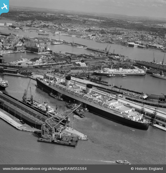
EAW051594 ENGLAND (1953). RMS Queen Elizabeth in Ocean Dock and SS New Australia in Empress Dock, Southampton, from the south-west, 1953
© Copyright OpenStreetMap contributors and licensed by the OpenStreetMap Foundation. 2026. Cartography is licensed as CC BY-SA.
Nearby Images (39)
Details
| Title | [EAW051594] RMS Queen Elizabeth in Ocean Dock and SS New Australia in Empress Dock, Southampton, from the south-west, 1953 |
| Reference | EAW051594 |
| Date | 26-August-1953 |
| Link | |
| Place name | SOUTHAMPTON |
| Parish | |
| District | |
| Country | ENGLAND |
| Easting / Northing | 442284, 110294 |
| Longitude / Latitude | -1.3987629954601, 50.890027445949 |
| National Grid Reference | SU423103 |
Pins
Be the first to add a comment to this image!


![[EAW051594] RMS Queen Elizabeth in Ocean Dock and SS New Australia in Empress Dock, Southampton, from the south-west, 1953](http://britainfromabove.org.uk/sites/all/libraries/aerofilms-images/public/100x100/EAW/051/EAW051594.jpg)
![[EAW035248] RMS Queen Mary at Ocean Dock, Southampton, 1951](http://britainfromabove.org.uk/sites/all/libraries/aerofilms-images/public/100x100/EAW/035/EAW035248.jpg)
![[EPW009070] Ocean Dock, Southampton, from the south-west, 1923](http://britainfromabove.org.uk/sites/all/libraries/aerofilms-images/public/100x100/EPW/009/EPW009070.jpg)
![[EAW046509] RMS Queen Elizabeth berthed at Ocean Dock, Southampton, 1952](http://britainfromabove.org.uk/sites/all/libraries/aerofilms-images/public/100x100/EAW/046/EAW046509.jpg)
![[EAW051593] RMS Queen Elizabeth in Ocean Dock and environs, Southampton, from the south-west, 1953](http://britainfromabove.org.uk/sites/all/libraries/aerofilms-images/public/100x100/EAW/051/EAW051593.jpg)
![[EAW001371] The Grey Ghost (RMS Queen Mary) in Ocean Dock, Southampton, 1946](http://britainfromabove.org.uk/sites/all/libraries/aerofilms-images/public/100x100/EAW/001/EAW001371.jpg)
![[EPW009069] Vessels in dock, Southampton, 1923](http://britainfromabove.org.uk/sites/all/libraries/aerofilms-images/public/100x100/EPW/009/EPW009069.jpg)
![[EAW035250] RMS Queen Mary at Ocean Dock and environs, Southampton, 1951. This image has been produced from a print.](http://britainfromabove.org.uk/sites/all/libraries/aerofilms-images/public/100x100/EAW/035/EAW035250.jpg)
![[EAW033412] Ocean Dock and Empress Dock, Southampton, 1950](http://britainfromabove.org.uk/sites/all/libraries/aerofilms-images/public/100x100/EAW/033/EAW033412.jpg)
![[EPW041070] The RMS Olympic and environs, Southampton, from the west, 1933](http://britainfromabove.org.uk/sites/all/libraries/aerofilms-images/public/100x100/EPW/041/EPW041070.jpg)
![[EAW033429] The Docks, Southampton, 1950. This image has been produced from a print.](http://britainfromabove.org.uk/sites/all/libraries/aerofilms-images/public/100x100/EAW/033/EAW033429.jpg)
![[EAW033407] Ocean Dock and Empress Dock, Southampton, 1950](http://britainfromabove.org.uk/sites/all/libraries/aerofilms-images/public/100x100/EAW/033/EAW033407.jpg)
![[EAW001373] The Grey Ghost (RMS Queen Mary) in Ocean Dock, Southampton, 1946](http://britainfromabove.org.uk/sites/all/libraries/aerofilms-images/public/100x100/EAW/001/EAW001373.jpg)
![[EAW015268] RMS Queen Elizabeth berthed at Ocean Dock, Southampton, 1948](http://britainfromabove.org.uk/sites/all/libraries/aerofilms-images/public/100x100/EAW/015/EAW015268.jpg)
![[EAW001372] The Grey Ghost (RMS Queen Mary) in Ocean Dock, Southampton, 1946](http://britainfromabove.org.uk/sites/all/libraries/aerofilms-images/public/100x100/EAW/001/EAW001372.jpg)
![[EAW035249] RMS Queen Mary at Ocean Dock, Southampton, 1951. This image has been produced from a print.](http://britainfromabove.org.uk/sites/all/libraries/aerofilms-images/public/100x100/EAW/035/EAW035249.jpg)
![[EAW046508] RMS Queen Elizabeth berthed at Ocean Dock, Southampton, 1952](http://britainfromabove.org.uk/sites/all/libraries/aerofilms-images/public/100x100/EAW/046/EAW046508.jpg)
![[EAW001370] The Grey Ghost (RMS Queen Mary) in Ocean Dock, Southampton, 1946](http://britainfromabove.org.uk/sites/all/libraries/aerofilms-images/public/100x100/EAW/001/EAW001370.jpg)
![[EPW032343] The Docks including the Ocean Dock, the Empress Dock and the Outer Dock, Southampton, from the south-west, 1930. This image has been produced from a damaged negative.](http://britainfromabove.org.uk/sites/all/libraries/aerofilms-images/public/100x100/EPW/032/EPW032343.jpg)
![[EAW001361] The Docks, Southampton, 1946](http://britainfromabove.org.uk/sites/all/libraries/aerofilms-images/public/100x100/EAW/001/EAW001361.jpg)
![[EPW009071] The Empress Dock, Southampton, 1923](http://britainfromabove.org.uk/sites/all/libraries/aerofilms-images/public/100x100/EPW/009/EPW009071.jpg)
![[EPW000238] Vessels on Southampton Water, Southampton, 1920](http://britainfromabove.org.uk/sites/all/libraries/aerofilms-images/public/100x100/EPW/000/EPW000238.jpg)
![[EAW033413] The Docks, Southampton, from the south-west, 1950](http://britainfromabove.org.uk/sites/all/libraries/aerofilms-images/public/100x100/EAW/033/EAW033413.jpg)
![[EAW001368] The Grey Ghost (RMS Queen Mary) in Ocean Dock, Southampton, 1946](http://britainfromabove.org.uk/sites/all/libraries/aerofilms-images/public/100x100/EAW/001/EAW001368.jpg)
![[EAW046507] RMS Queen Elizabeth berthed at Ocean Dock, Southampton, 1952](http://britainfromabove.org.uk/sites/all/libraries/aerofilms-images/public/100x100/EAW/046/EAW046507.jpg)
![[EPW032345] The Floating Dock, ocean liners in the Ocean Dock and the Empress Dock, Southampton, 1930](http://britainfromabove.org.uk/sites/all/libraries/aerofilms-images/public/100x100/EPW/032/EPW032345.jpg)
![[EAW033406] Ocean Dock and Empress Dock, Southampton, 1950](http://britainfromabove.org.uk/sites/all/libraries/aerofilms-images/public/100x100/EAW/033/EAW033406.jpg)
![[EPW009074] Vessels in dock, Southampton, 1923](http://britainfromabove.org.uk/sites/all/libraries/aerofilms-images/public/100x100/EPW/009/EPW009074.jpg)
![[EPW020527] RMS Berengaria in the Ocean Dock, Southampton, 1928](http://britainfromabove.org.uk/sites/all/libraries/aerofilms-images/public/100x100/EPW/020/EPW020527.jpg)
![[EAW191249] The Queen Elizabeth 2 in Ocean Dock, Southampton, 1969](http://britainfromabove.org.uk/sites/all/libraries/aerofilms-images/public/100x100/EAW/191/EAW191249.jpg)
![[EAW008845] RMS Queen Elizabeth at Ocean Dock, Southampton, 1947](http://britainfromabove.org.uk/sites/all/libraries/aerofilms-images/public/100x100/EAW/008/EAW008845.jpg)
![[EPW037408] Ocean liners moored in the Ocean Dock and the Empress Dock, Southampton, from the south-west, 1932](http://britainfromabove.org.uk/sites/all/libraries/aerofilms-images/public/100x100/EPW/037/EPW037408.jpg)
![[EAW046505] RMS Queen Elizabeth berthed at Ocean Dock, Southampton, 1952](http://britainfromabove.org.uk/sites/all/libraries/aerofilms-images/public/100x100/EAW/046/EAW046505.jpg)
![[EAW033415] The Docks, Southampton, from the north-west, 1950](http://britainfromabove.org.uk/sites/all/libraries/aerofilms-images/public/100x100/EAW/033/EAW033415.jpg)
![[EAW046506] RMS Queen Elizabeth berthed at Ocean Dock, Southampton, 1952](http://britainfromabove.org.uk/sites/all/libraries/aerofilms-images/public/100x100/EAW/046/EAW046506.jpg)
![[EAW001346] Ocean Dock and Empress Dock, Southampton, from the north, 1946](http://britainfromabove.org.uk/sites/all/libraries/aerofilms-images/public/100x100/EAW/001/EAW001346.jpg)
![[EPW020445] Floating Dock, Southampton, from the south, 1928](http://britainfromabove.org.uk/sites/all/libraries/aerofilms-images/public/100x100/EPW/020/EPW020445.jpg)
![[EPW037430] Ocean Liners in Southampton Docks, Southampton, 1932. This image has been produced from a copy-negative affected by flare.](http://britainfromabove.org.uk/sites/all/libraries/aerofilms-images/public/100x100/EPW/037/EPW037430.jpg)
![[EAW001355] The Docks, Southampton, from the south-east, 1946](http://britainfromabove.org.uk/sites/all/libraries/aerofilms-images/public/100x100/EAW/001/EAW001355.jpg)