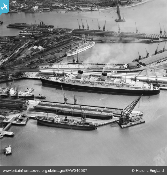
EAW046507 ENGLAND (1952). RMS Queen Elizabeth berthed at Ocean Dock, Southampton, 1952
© Copyright OpenStreetMap contributors and licensed by the OpenStreetMap Foundation. 2026. Cartography is licensed as CC BY-SA.
Nearby Images (40)
Details
| Title | [EAW046507] RMS Queen Elizabeth berthed at Ocean Dock, Southampton, 1952 |
| Reference | EAW046507 |
| Date | 28-August-1952 |
| Link | |
| Place name | SOUTHAMPTON |
| Parish | |
| District | |
| Country | ENGLAND |
| Easting / Northing | 442394, 110465 |
| Longitude / Latitude | -1.3971791461114, 50.891557174516 |
| National Grid Reference | SU424105 |
Pins

railwaymanx |
Monday 29th of December 2014 04:56:04 PM |


![[EAW046507] RMS Queen Elizabeth berthed at Ocean Dock, Southampton, 1952](http://britainfromabove.org.uk/sites/all/libraries/aerofilms-images/public/100x100/EAW/046/EAW046507.jpg)
![[EPW032345] The Floating Dock, ocean liners in the Ocean Dock and the Empress Dock, Southampton, 1930](http://britainfromabove.org.uk/sites/all/libraries/aerofilms-images/public/100x100/EPW/032/EPW032345.jpg)
![[EAW001368] The Grey Ghost (RMS Queen Mary) in Ocean Dock, Southampton, 1946](http://britainfromabove.org.uk/sites/all/libraries/aerofilms-images/public/100x100/EAW/001/EAW001368.jpg)
![[EAW191249] The Queen Elizabeth 2 in Ocean Dock, Southampton, 1969](http://britainfromabove.org.uk/sites/all/libraries/aerofilms-images/public/100x100/EAW/191/EAW191249.jpg)
![[EAW046508] RMS Queen Elizabeth berthed at Ocean Dock, Southampton, 1952](http://britainfromabove.org.uk/sites/all/libraries/aerofilms-images/public/100x100/EAW/046/EAW046508.jpg)
![[EPW009071] The Empress Dock, Southampton, 1923](http://britainfromabove.org.uk/sites/all/libraries/aerofilms-images/public/100x100/EPW/009/EPW009071.jpg)
![[EAW001372] The Grey Ghost (RMS Queen Mary) in Ocean Dock, Southampton, 1946](http://britainfromabove.org.uk/sites/all/libraries/aerofilms-images/public/100x100/EAW/001/EAW001372.jpg)
![[EAW008845] RMS Queen Elizabeth at Ocean Dock, Southampton, 1947](http://britainfromabove.org.uk/sites/all/libraries/aerofilms-images/public/100x100/EAW/008/EAW008845.jpg)
![[EPW009074] Vessels in dock, Southampton, 1923](http://britainfromabove.org.uk/sites/all/libraries/aerofilms-images/public/100x100/EPW/009/EPW009074.jpg)
![[EAW001370] The Grey Ghost (RMS Queen Mary) in Ocean Dock, Southampton, 1946](http://britainfromabove.org.uk/sites/all/libraries/aerofilms-images/public/100x100/EAW/001/EAW001370.jpg)
![[EAW035249] RMS Queen Mary at Ocean Dock, Southampton, 1951. This image has been produced from a print.](http://britainfromabove.org.uk/sites/all/libraries/aerofilms-images/public/100x100/EAW/035/EAW035249.jpg)
![[EPW020527] RMS Berengaria in the Ocean Dock, Southampton, 1928](http://britainfromabove.org.uk/sites/all/libraries/aerofilms-images/public/100x100/EPW/020/EPW020527.jpg)
![[EAW033415] The Docks, Southampton, from the north-west, 1950](http://britainfromabove.org.uk/sites/all/libraries/aerofilms-images/public/100x100/EAW/033/EAW033415.jpg)
![[EAW033406] Ocean Dock and Empress Dock, Southampton, 1950](http://britainfromabove.org.uk/sites/all/libraries/aerofilms-images/public/100x100/EAW/033/EAW033406.jpg)
![[EAW001371] The Grey Ghost (RMS Queen Mary) in Ocean Dock, Southampton, 1946](http://britainfromabove.org.uk/sites/all/libraries/aerofilms-images/public/100x100/EAW/001/EAW001371.jpg)
![[EAW033412] Ocean Dock and Empress Dock, Southampton, 1950](http://britainfromabove.org.uk/sites/all/libraries/aerofilms-images/public/100x100/EAW/033/EAW033412.jpg)
![[EPW009069] Vessels in dock, Southampton, 1923](http://britainfromabove.org.uk/sites/all/libraries/aerofilms-images/public/100x100/EPW/009/EPW009069.jpg)
![[EAW033429] The Docks, Southampton, 1950. This image has been produced from a print.](http://britainfromabove.org.uk/sites/all/libraries/aerofilms-images/public/100x100/EAW/033/EAW033429.jpg)
![[EAW015267] RMS Queen Elizabeth berthed at Ocean Dock, Southampton, 1948](http://britainfromabove.org.uk/sites/all/libraries/aerofilms-images/public/100x100/EAW/015/EAW015267.jpg)
![[EAW033407] Ocean Dock and Empress Dock, Southampton, 1950](http://britainfromabove.org.uk/sites/all/libraries/aerofilms-images/public/100x100/EAW/033/EAW033407.jpg)
![[EAW035250] RMS Queen Mary at Ocean Dock and environs, Southampton, 1951. This image has been produced from a print.](http://britainfromabove.org.uk/sites/all/libraries/aerofilms-images/public/100x100/EAW/035/EAW035250.jpg)
![[EPW020455] The Docks, Floating Dock and RMS Berengaria, Southampton, 1928](http://britainfromabove.org.uk/sites/all/libraries/aerofilms-images/public/100x100/EPW/020/EPW020455.jpg)
![[EAW051593] RMS Queen Elizabeth in Ocean Dock and environs, Southampton, from the south-west, 1953](http://britainfromabove.org.uk/sites/all/libraries/aerofilms-images/public/100x100/EAW/051/EAW051593.jpg)
![[EAW001373] The Grey Ghost (RMS Queen Mary) in Ocean Dock, Southampton, 1946](http://britainfromabove.org.uk/sites/all/libraries/aerofilms-images/public/100x100/EAW/001/EAW001373.jpg)
![[EAW001374] The Grey Ghost (RMS Queen Mary) in Ocean Dock, Southampton, 1946](http://britainfromabove.org.uk/sites/all/libraries/aerofilms-images/public/100x100/EAW/001/EAW001374.jpg)
![[EPW020451] Empress Dock and RMS Berengaria, Southampton, from the east, 1928](http://britainfromabove.org.uk/sites/all/libraries/aerofilms-images/public/100x100/EPW/020/EPW020451.jpg)
![[EAW035248] RMS Queen Mary at Ocean Dock, Southampton, 1951](http://britainfromabove.org.uk/sites/all/libraries/aerofilms-images/public/100x100/EAW/035/EAW035248.jpg)
![[EAW015268] RMS Queen Elizabeth berthed at Ocean Dock, Southampton, 1948](http://britainfromabove.org.uk/sites/all/libraries/aerofilms-images/public/100x100/EAW/015/EAW015268.jpg)
![[EAW046506] RMS Queen Elizabeth berthed at Ocean Dock, Southampton, 1952](http://britainfromabove.org.uk/sites/all/libraries/aerofilms-images/public/100x100/EAW/046/EAW046506.jpg)
![[EPW020450] Ocean Dock with RMS Berengaria in dock, Southampton, from the north-east, 1928](http://britainfromabove.org.uk/sites/all/libraries/aerofilms-images/public/100x100/EPW/020/EPW020450.jpg)
![[EAW051594] RMS Queen Elizabeth in Ocean Dock and SS New Australia in Empress Dock, Southampton, from the south-west, 1953](http://britainfromabove.org.uk/sites/all/libraries/aerofilms-images/public/100x100/EAW/051/EAW051594.jpg)
![[EAW001361] The Docks, Southampton, 1946](http://britainfromabove.org.uk/sites/all/libraries/aerofilms-images/public/100x100/EAW/001/EAW001361.jpg)
![[EAW046505] RMS Queen Elizabeth berthed at Ocean Dock, Southampton, 1952](http://britainfromabove.org.uk/sites/all/libraries/aerofilms-images/public/100x100/EAW/046/EAW046505.jpg)
![[EPW000322] Ocean Dock, Inner Dock and Outer Dock, Southampton, from the west, 1920](http://britainfromabove.org.uk/sites/all/libraries/aerofilms-images/public/100x100/EPW/000/EPW000322.jpg)
![[EAW046509] RMS Queen Elizabeth berthed at Ocean Dock, Southampton, 1952](http://britainfromabove.org.uk/sites/all/libraries/aerofilms-images/public/100x100/EAW/046/EAW046509.jpg)
![[EPW009070] Ocean Dock, Southampton, from the south-west, 1923](http://britainfromabove.org.uk/sites/all/libraries/aerofilms-images/public/100x100/EPW/009/EPW009070.jpg)
![[EAW086604] Empress and Ocean Dock, Southampton, 1961](http://britainfromabove.org.uk/sites/all/libraries/aerofilms-images/public/100x100/EAW/086/EAW086604.jpg)
![[EAW020646] The British Overseas Airways Corporation (BOAC) Marine Airport and the surrounding docks, Southampton, 1948](http://britainfromabove.org.uk/sites/all/libraries/aerofilms-images/public/100x100/EAW/020/EAW020646.jpg)
![[EPW041070] The RMS Olympic and environs, Southampton, from the west, 1933](http://britainfromabove.org.uk/sites/all/libraries/aerofilms-images/public/100x100/EPW/041/EPW041070.jpg)
![[EAW008802] Harland & Wolff Ltd Shipbuilding and Engineering Works and the docks, Southampton, from the south-west, 1947](http://britainfromabove.org.uk/sites/all/libraries/aerofilms-images/public/100x100/EAW/008/EAW008802.jpg)