
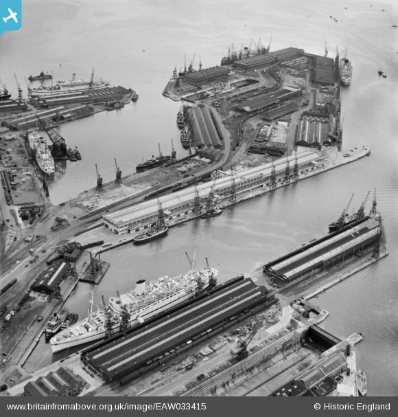
EAW033415 ENGLAND (1950). The Docks, Southampton, from the north-west, 1950
© Copyright OpenStreetMap contributors and licensed by the OpenStreetMap Foundation. 2026. Cartography is licensed as CC BY-SA.
Nearby Images (43)
EAW033415

EAW008845

EAW015267

EPW009074

EPW020527

EPW020455

EAW001370
 in Ocean Dock, Southampton, 1946")
EAW001368
 in Ocean Dock, Southampton, 1946")
EAW046507

EAW191249

EPW032345

EAW001374
 in Ocean Dock, Southampton, 1946")
EAW046508

EAW001372
 in Ocean Dock, Southampton, 1946")
EAW015268

EPW009071

EAW001361

EPW020450

EAW035249

EAW001371
 in Ocean Dock, Southampton, 1946")
EPW009069

EAW033412

EPW000322

EAW008803

EAW001375

EAW020646
 Marine Airport and the surrounding docks, Southampton, 1948")
EAW033406

EAW033429

EAW008796

EAW189228

EAW008802

EAW020645
 Marine Airport and the surrounding docks, Southampton, 1948")
EAW008795

EPW037430

EAW033407

EAW051594

EAW035250

EAW035248

EAW051593

EAW001373
 in Ocean Dock, Southampton, 1946")
EPW020451

EAW046506

EAW046505

Details
| Title | [EAW033415] The Docks, Southampton, from the north-west, 1950 |
| Reference | EAW033415 |
| Date | 10-October-1950 |
| Link | |
| Place name | SOUTHAMPTON |
| Parish | |
| District | |
| Country | ENGLAND |
| Easting / Northing | 442318, 110537 |
| Longitude / Latitude | -1.3982514199454, 50.892210241691 |
| National Grid Reference | SU423105 |
Pins

John Wass |
Wednesday 18th of March 2015 07:55:56 PM |