
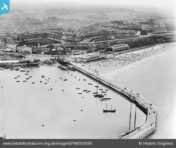
EPW000596 ENGLAND (1920). The Royal Harbour, Ramsgate, 1920
© Copyright OpenStreetMap contributors and licensed by the OpenStreetMap Foundation. 2026. Cartography is licensed as CC BY-SA.
Nearby Images (48)
EPW000596

EPW039353

EPW042864

EPW018646

EAW020486

EPW000600

EPW042861

EAW009051

EAW024843

EPW035449

EPW039324

EAW009055

EPW048858

EPW000092

EPW009172

EAW017589

EPW000087

EPW000096

EPW039325

EAW015836

EPW009174

EPW018649

EPW009173

EPW042859

EPW035453

EAW009050

EAW024842

EAW006169

EAW008999

EPW048783

EAW009056

EAW006165

EAW009054

EAW009058

EAW024844

EAW009014

EAW006166

EPW000093

EAW009009

EAW009006

EAW006164

EPW018650

EAW006170

EAW009007

EAW009015

EPW000604

EAW009052

EAW020487

Details
| Title | [EPW000596] The Royal Harbour, Ramsgate, 1920 |
| Reference | EPW000596 |
| Date | April-1920 |
| Link | |
| Place name | RAMSGATE |
| Parish | RAMSGATE |
| District | |
| Country | ENGLAND |
| Easting / Northing | 638628, 164624 |
| Longitude / Latitude | 1.4258643663167, 51.33005276716 |
| National Grid Reference | TR386646 |
Pins

Rambler |
Thursday 1st of October 2015 12:00:18 PM | |

Alan McFaden |
Thursday 4th of December 2014 06:33:05 PM | |
|
Alan McFaden |
Thursday 4th of December 2014 06:32:30 PM | |
|
Alan McFaden |
Thursday 4th of December 2014 06:31:57 PM | |
|
Alan McFaden |
Thursday 4th of December 2014 06:31:21 PM | |
|
EZTD |
Tuesday 10th of July 2012 10:07:05 PM | |
Closed 1926 by the then relatively new Southern Railway as part of a rationalisation of railway facilities in the area. |
John W |
Friday 7th of October 2016 09:16:54 PM |


User Comment Contributions
Ramsgate Harbour |
Alan McFaden |
Thursday 4th of December 2014 06:30:29 PM |