
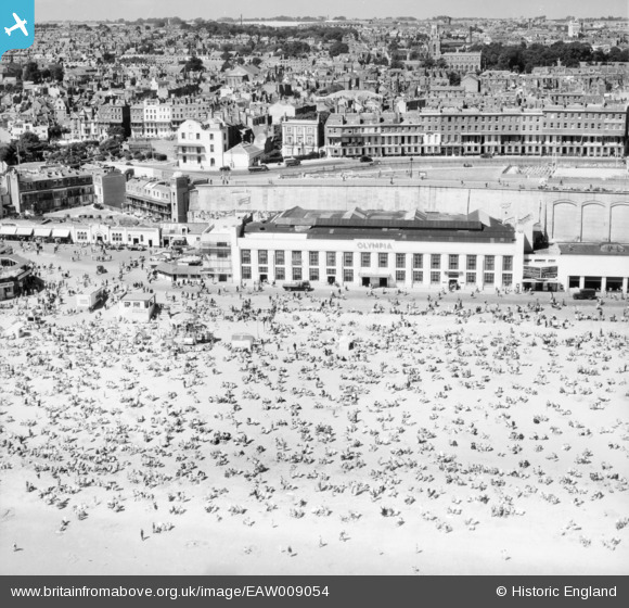
EAW009054 ENGLAND (1947). Crowds on Ramsgate Sands in front of the Ramsgate Olympia, Ramsgate, from the south-east, 1947
© Copyright OpenStreetMap contributors and licensed by the OpenStreetMap Foundation. 2026. Cartography is licensed as CC BY-SA.
Nearby Images (48)
EAW009054

EAW017591

EPW009175

EPW042859

EPW009174

EAW006167

EAW009015

EPW018649

EAW009052

EAW024842

EAW009004

EAW024844

EAW009014

EPW009173

EPW035453

EPW009172

EAW009053

EAW009056

EAW009058

EPW039325

EAW006166

EAW006170

EAW009016

EPW039394

EPW000087

EAW006169

EPW000381

EPW000599

EPW042861

EPW000093

EAW009055

EAW006171

EAW006168

EAW009005

EAW024843

EAW009057

EAW009051

EAW017590

EPW039324

EPW035450

EAW009063

EPW048783

EPW039353

EPW042864

EAW009049

EPW000596

EAW009003

EPW000096

Details
| Title | [EAW009054] Crowds on Ramsgate Sands in front of the Ramsgate Olympia, Ramsgate, from the south-east, 1947 |
| Reference | EAW009054 |
| Date | 12-August-1947 |
| Link | |
| Place name | RAMSGATE |
| Parish | RAMSGATE |
| District | |
| Country | ENGLAND |
| Easting / Northing | 638759, 164807 |
| Longitude / Latitude | 1.4278640894568, 51.331640518248 |
| National Grid Reference | TR388648 |
Pins
Be the first to add a comment to this image!