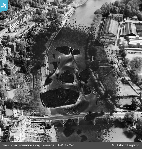
EAW042757 ENGLAND (1952). Richmond Bridge, Richmond, 1952. This image has been produced from a damaged negative.
© Copyright OpenStreetMap contributors and licensed by the OpenStreetMap Foundation. 2026. Cartography is licensed as CC BY-SA.
Nearby Images (31)
Details
| Title | [EAW042757] Richmond Bridge, Richmond, 1952. This image has been produced from a damaged negative. |
| Reference | EAW042757 |
| Date | 29-April-1952 |
| Link | |
| Place name | RICHMOND |
| Parish | |
| District | |
| Country | ENGLAND |
| Easting / Northing | 517824, 174405 |
| Longitude / Latitude | -0.30397919523045, 51.455859079794 |
| National Grid Reference | TQ178744 |
Pins

richmondboy |
Sunday 8th of July 2018 09:39:51 AM |


![[EAW042757] Richmond Bridge, Richmond, 1952. This image has been produced from a damaged negative.](http://britainfromabove.org.uk/sites/all/libraries/aerofilms-images/public/100x100/EAW/042/EAW042757.jpg)
![[EAW026798] The town, Richmond, from the south, 1949](http://britainfromabove.org.uk/sites/all/libraries/aerofilms-images/public/100x100/EAW/026/EAW026798.jpg)
![[EPW022838] Richmond Bridge, Richmond, 1928](http://britainfromabove.org.uk/sites/all/libraries/aerofilms-images/public/100x100/EPW/022/EPW022838.jpg)
![[EPW022844] Richmond Bridge, Richmond, 1928](http://britainfromabove.org.uk/sites/all/libraries/aerofilms-images/public/100x100/EPW/022/EPW022844.jpg)
![[EAW026799] Richmond Bridge, Richmond, from the south, 1949](http://britainfromabove.org.uk/sites/all/libraries/aerofilms-images/public/100x100/EAW/026/EAW026799.jpg)
![[EPW008871] Richmond Bridge and the town centre, Richmond, 1923](http://britainfromabove.org.uk/sites/all/libraries/aerofilms-images/public/100x100/EPW/008/EPW008871.jpg)
![[EAW042759] Richmond Bridge and the surrounding area, Richmond, 1952](http://britainfromabove.org.uk/sites/all/libraries/aerofilms-images/public/100x100/EAW/042/EAW042759.jpg)
![[EAW042758] Richmond Bridge, Richmond, 1952. This image has been produced from a damaged negative.](http://britainfromabove.org.uk/sites/all/libraries/aerofilms-images/public/100x100/EAW/042/EAW042758.jpg)
![[EPW001693] Richmond and Richmond Bridge, Richmond, 1920](http://britainfromabove.org.uk/sites/all/libraries/aerofilms-images/public/100x100/EPW/001/EPW001693.jpg)
![[EPW022837] Thames skiffs mored at Richmond Bridge, Richmond, 1928](http://britainfromabove.org.uk/sites/all/libraries/aerofilms-images/public/100x100/EPW/022/EPW022837.jpg)
![[EAW036494] The Metal Name Plate Works on Cambridge Road, Twickenham, 1951. This image has been produced from a print marked by Aerofilms Ltd for photo editing.](http://britainfromabove.org.uk/sites/all/libraries/aerofilms-images/public/100x100/EAW/036/EAW036494.jpg)
![[EPW001695] Richmond and Richmond Bridge, Richmond, 1920](http://britainfromabove.org.uk/sites/all/libraries/aerofilms-images/public/100x100/EPW/001/EPW001695.jpg)
![[EAW036493] The Metal Name Plate Works on Cambridge Road, Twickenham, 1951. This image has been produced from a print marked by Aerofilms Ltd for photo editing.](http://britainfromabove.org.uk/sites/all/libraries/aerofilms-images/public/100x100/EAW/036/EAW036493.jpg)
![[EPW044552] Richmond Bridge, Corporation Island and the town, Richmond, 1934](http://britainfromabove.org.uk/sites/all/libraries/aerofilms-images/public/100x100/EPW/044/EPW044552.jpg)
![[EAW036495] The Metal Name Plate Works on Cambridge Road, Twickenham, 1951. This image has been produced from a print marked by Aerofilms Ltd for photo editing.](http://britainfromabove.org.uk/sites/all/libraries/aerofilms-images/public/100x100/EAW/036/EAW036495.jpg)
![[EAW008242] Richmond Bridge and environs, Richmond, 1947](http://britainfromabove.org.uk/sites/all/libraries/aerofilms-images/public/100x100/EAW/008/EAW008242.jpg)
![[EAW036500] The Metal Name Plate Works on Cambridge Road, Twickenham, 1951. This image has been produced from a print marked by Aerofilms Ltd for photo editing.](http://britainfromabove.org.uk/sites/all/libraries/aerofilms-images/public/100x100/EAW/036/EAW036500.jpg)
![[EPW036445] The British Legion Poppy Factory, the River Thames and Terrace Gardens, Richmond, 1931](http://britainfromabove.org.uk/sites/all/libraries/aerofilms-images/public/100x100/EPW/036/EPW036445.jpg)
![[EAW036497] The Metal Name Plate Works on Cambridge Road and environs, Twickenham, 1951. This image has been produced from a print marked by Aerofilms Ltd for photo editing.](http://britainfromabove.org.uk/sites/all/libraries/aerofilms-images/public/100x100/EAW/036/EAW036497.jpg)
![[EPW036448] The British Legion Poppy Factory, the River Thames and Terrace Gardens, Richmond, 1931](http://britainfromabove.org.uk/sites/all/libraries/aerofilms-images/public/100x100/EPW/036/EPW036448.jpg)
![[EPW036449] The British Legion Poppy Factory, Terrace Gardens and the Sports Drome, Richmond, 1931](http://britainfromabove.org.uk/sites/all/libraries/aerofilms-images/public/100x100/EPW/036/EPW036449.jpg)
![[EAW026800] The town centre, Richmond, from the south, 1949](http://britainfromabove.org.uk/sites/all/libraries/aerofilms-images/public/100x100/EAW/026/EAW026800.jpg)
![[EPW001696] Richmond and Richmond Bridge, Richmond, 1920](http://britainfromabove.org.uk/sites/all/libraries/aerofilms-images/public/100x100/EPW/001/EPW001696.jpg)
![[EPW056173] Richmond Bridge and surroundings, Richmond, 1937](http://britainfromabove.org.uk/sites/all/libraries/aerofilms-images/public/100x100/EPW/056/EPW056173.jpg)
![[EPW036443] The British Legion Poppy Factory, the River Thames and Richmond Hill, Richmond, 1931](http://britainfromabove.org.uk/sites/all/libraries/aerofilms-images/public/100x100/EPW/036/EPW036443.jpg)
![[EPW001694] Richmond and Richmond Bridge, Richmond, 1920](http://britainfromabove.org.uk/sites/all/libraries/aerofilms-images/public/100x100/EPW/001/EPW001694.jpg)
![[EPW036450] The British Legion Poppy Factory, the River Thames and Richmond Hill, Richmond, 1931](http://britainfromabove.org.uk/sites/all/libraries/aerofilms-images/public/100x100/EPW/036/EPW036450.jpg)
![[EPW036444] The British Legion Poppy Factory, Richmond Hill and environs, Richmond, 1931](http://britainfromabove.org.uk/sites/all/libraries/aerofilms-images/public/100x100/EPW/036/EPW036444.jpg)
![[EPW008870] The River Thames at Petersham Road, Richmond, 1923](http://britainfromabove.org.uk/sites/all/libraries/aerofilms-images/public/100x100/EPW/008/EPW008870.jpg)
![[EPW036447] The British Legion Poppy Factory, Terrace Gardens and environs, Richmond, 1931](http://britainfromabove.org.uk/sites/all/libraries/aerofilms-images/public/100x100/EPW/036/EPW036447.jpg)
![[EPW022841] Bridges over the River Thames, Richmond, from the south-east, 1928](http://britainfromabove.org.uk/sites/all/libraries/aerofilms-images/public/100x100/EPW/022/EPW022841.jpg)