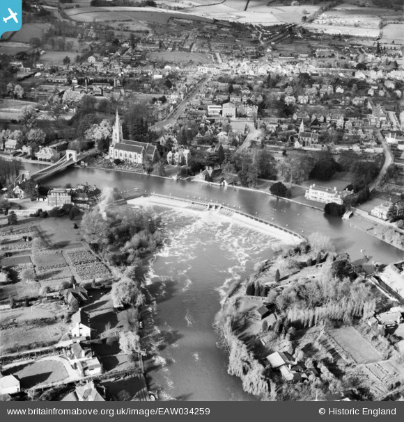
EAW034259 ENGLAND (1950). Marlow Weir and the town, Marlow, 1950
© Copyright OpenStreetMap contributors and licensed by the OpenStreetMap Foundation. 2025. Cartography is licensed as CC BY-SA.
Nearby Images (19)
Details
| Title | [EAW034259] Marlow Weir and the town, Marlow, 1950 |
| Reference | EAW034259 |
| Date | 14-November-1950 |
| Link | |
| Place name | MARLOW |
| Parish | MARLOW |
| District | |
| Country | ENGLAND |
| Easting / Northing | 485243, 186157 |
| Longitude / Latitude | -0.76998681053539, 51.567359707053 |
| National Grid Reference | SU852862 |
Pins

misterjohn |
Tuesday 3rd of January 2023 12:45:36 PM | |

misterjohn |
Tuesday 3rd of January 2023 12:44:19 PM | |

misterjohn |
Tuesday 3rd of January 2023 12:42:48 PM | |

misterjohn |
Tuesday 3rd of January 2023 12:41:43 PM | |

misterjohn |
Tuesday 3rd of January 2023 12:41:16 PM |


![[EAW034259] Marlow Weir and the town, Marlow, 1950](http://britainfromabove.org.uk/sites/all/libraries/aerofilms-images/public/100x100/EAW/034/EAW034259.jpg)
![[EPW000915] Marlow Bridge and All Saints Church, Marlow, 1920](http://britainfromabove.org.uk/sites/all/libraries/aerofilms-images/public/100x100/EPW/000/EPW000915.jpg)
![[EAW028004] Marlow Weir, Bisham, 1950](http://britainfromabove.org.uk/sites/all/libraries/aerofilms-images/public/100x100/EAW/028/EAW028004.jpg)
![[EAW028002] Marlow Weir, Bisham, 1950](http://britainfromabove.org.uk/sites/all/libraries/aerofilms-images/public/100x100/EAW/028/EAW028002.jpg)
![[EPW000922] Marlow Weir, Marlow, 1920](http://britainfromabove.org.uk/sites/all/libraries/aerofilms-images/public/100x100/EPW/000/EPW000922.jpg)
![[EAW028003] Marlow Bridge, Marlow Weir and the River Thames, Bisham, 1950](http://britainfromabove.org.uk/sites/all/libraries/aerofilms-images/public/100x100/EAW/028/EAW028003.jpg)
![[EAW034636] Marlow Weir on the River Thames, Marlow, 1951](http://britainfromabove.org.uk/sites/all/libraries/aerofilms-images/public/100x100/EAW/034/EAW034636.jpg)
![[EAW034635] Marlow Weir on the River Thames, Marlow, 1951](http://britainfromabove.org.uk/sites/all/libraries/aerofilms-images/public/100x100/EAW/034/EAW034635.jpg)
![[EPW052602] Marlow and the River Thames, Stoney Ware, 1937. This image has been produced from a copy-negative.](http://britainfromabove.org.uk/sites/all/libraries/aerofilms-images/public/100x100/EPW/052/EPW052602.jpg)
![[EAW045413] Lock Island, All Saints' Church and the town, Marlow, 1952](http://britainfromabove.org.uk/sites/all/libraries/aerofilms-images/public/100x100/EAW/045/EAW045413.jpg)
![[EAW045411] Lock Island, All Saints' Church and the surrounding area, Marlow, 1952](http://britainfromabove.org.uk/sites/all/libraries/aerofilms-images/public/100x100/EAW/045/EAW045411.jpg)
![[EAW028005] Marlow Weir, All Saints' Church and environs, Bisham, 1950](http://britainfromabove.org.uk/sites/all/libraries/aerofilms-images/public/100x100/EAW/028/EAW028005.jpg)
![[EAW045412] Lock Island, All Saints' Church and the surrounding area, Marlow, 1952](http://britainfromabove.org.uk/sites/all/libraries/aerofilms-images/public/100x100/EAW/045/EAW045412.jpg)
![[EPW022689] Marlow Suspension Bridge and All Saints' Church, Marlow, 1928](http://britainfromabove.org.uk/sites/all/libraries/aerofilms-images/public/100x100/EPW/022/EPW022689.jpg)
![[EPW022691] All Saints' Church alongside Marlow Bridge and Weir, Bisham, 1928. This image has been produced from a copy-negative.](http://britainfromabove.org.uk/sites/all/libraries/aerofilms-images/public/100x100/EPW/022/EPW022691.jpg)
![[EPW000923] Marlow and Marlow Weir, Marlow, 1920](http://britainfromabove.org.uk/sites/all/libraries/aerofilms-images/public/100x100/EPW/000/EPW000923.jpg)
![[EPW012123] The town, Marlow, 1924. This image has been produced from a copy-negative affected by flare.](http://britainfromabove.org.uk/sites/all/libraries/aerofilms-images/public/100x100/EPW/012/EPW012123.jpg)
![[EAW034257] Marlow Lock, Lock Island and the River Thames, Marlow, 1950](http://britainfromabove.org.uk/sites/all/libraries/aerofilms-images/public/100x100/EAW/034/EAW034257.jpg)
![[EPW052603] Marlow, the River Thames and Marlow Road, Stoney Ware, 1937. This image has been produced from a copy-negative.](http://britainfromabove.org.uk/sites/all/libraries/aerofilms-images/public/100x100/EPW/052/EPW052603.jpg)