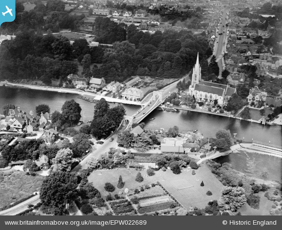
EPW022689 ENGLAND (1928). Marlow Suspension Bridge and All Saints' Church, Marlow, 1928
© Copyright OpenStreetMap contributors and licensed by the OpenStreetMap Foundation. 2025. Cartography is licensed as CC BY-SA.
Nearby Images (18)
Details
| Title | [EPW022689] Marlow Suspension Bridge and All Saints' Church, Marlow, 1928 |
| Reference | EPW022689 |
| Date | 15-August-1928 |
| Link | |
| Place name | MARLOW |
| Parish | MARLOW |
| District | |
| Country | ENGLAND |
| Easting / Northing | 485114, 186095 |
| Longitude / Latitude | -0.77186277453576, 51.566821797514 |
| National Grid Reference | SU851861 |
Pins
User Comment Contributions
Marlow Bridge, River Thames, Marlow, 26/04/2008 |

Class31 |
Wednesday 4th of June 2014 02:07:16 PM |


![[EPW022689] Marlow Suspension Bridge and All Saints' Church, Marlow, 1928](http://britainfromabove.org.uk/sites/all/libraries/aerofilms-images/public/100x100/EPW/022/EPW022689.jpg)
![[EPW022691] All Saints' Church alongside Marlow Bridge and Weir, Bisham, 1928. This image has been produced from a copy-negative.](http://britainfromabove.org.uk/sites/all/libraries/aerofilms-images/public/100x100/EPW/022/EPW022691.jpg)
![[EAW028003] Marlow Bridge, Marlow Weir and the River Thames, Bisham, 1950](http://britainfromabove.org.uk/sites/all/libraries/aerofilms-images/public/100x100/EAW/028/EAW028003.jpg)
![[EPW000915] Marlow Bridge and All Saints Church, Marlow, 1920](http://britainfromabove.org.uk/sites/all/libraries/aerofilms-images/public/100x100/EPW/000/EPW000915.jpg)
![[EPW000922] Marlow Weir, Marlow, 1920](http://britainfromabove.org.uk/sites/all/libraries/aerofilms-images/public/100x100/EPW/000/EPW000922.jpg)
![[EAW045411] Lock Island, All Saints' Church and the surrounding area, Marlow, 1952](http://britainfromabove.org.uk/sites/all/libraries/aerofilms-images/public/100x100/EAW/045/EAW045411.jpg)
![[EPW052602] Marlow and the River Thames, Stoney Ware, 1937. This image has been produced from a copy-negative.](http://britainfromabove.org.uk/sites/all/libraries/aerofilms-images/public/100x100/EPW/052/EPW052602.jpg)
![[EPW052603] Marlow, the River Thames and Marlow Road, Stoney Ware, 1937. This image has been produced from a copy-negative.](http://britainfromabove.org.uk/sites/all/libraries/aerofilms-images/public/100x100/EPW/052/EPW052603.jpg)
![[EAW034259] Marlow Weir and the town, Marlow, 1950](http://britainfromabove.org.uk/sites/all/libraries/aerofilms-images/public/100x100/EAW/034/EAW034259.jpg)
![[EAW028005] Marlow Weir, All Saints' Church and environs, Bisham, 1950](http://britainfromabove.org.uk/sites/all/libraries/aerofilms-images/public/100x100/EAW/028/EAW028005.jpg)
![[EAW028004] Marlow Weir, Bisham, 1950](http://britainfromabove.org.uk/sites/all/libraries/aerofilms-images/public/100x100/EAW/028/EAW028004.jpg)
![[EAW028002] Marlow Weir, Bisham, 1950](http://britainfromabove.org.uk/sites/all/libraries/aerofilms-images/public/100x100/EAW/028/EAW028002.jpg)
![[EPW000920] Marlow and Marlow Bridge, Marlow, from the west, 1920](http://britainfromabove.org.uk/sites/all/libraries/aerofilms-images/public/100x100/EPW/000/EPW000920.jpg)
![[EAW034636] Marlow Weir on the River Thames, Marlow, 1951](http://britainfromabove.org.uk/sites/all/libraries/aerofilms-images/public/100x100/EAW/034/EAW034636.jpg)
![[EAW034635] Marlow Weir on the River Thames, Marlow, 1951](http://britainfromabove.org.uk/sites/all/libraries/aerofilms-images/public/100x100/EAW/034/EAW034635.jpg)
![[EPW000923] Marlow and Marlow Weir, Marlow, 1920](http://britainfromabove.org.uk/sites/all/libraries/aerofilms-images/public/100x100/EPW/000/EPW000923.jpg)
![[EAW045413] Lock Island, All Saints' Church and the town, Marlow, 1952](http://britainfromabove.org.uk/sites/all/libraries/aerofilms-images/public/100x100/EAW/045/EAW045413.jpg)
![[EAW034258] Marlow Bridge and the River Thames, Marlow, from the south-west, 1950](http://britainfromabove.org.uk/sites/all/libraries/aerofilms-images/public/100x100/EAW/034/EAW034258.jpg)