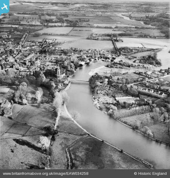
EAW034258 ENGLAND (1950). Marlow Bridge and the River Thames, Marlow, from the south-west, 1950
© Copyright OpenStreetMap contributors and licensed by the OpenStreetMap Foundation. 2025. Cartography is licensed as CC BY-SA.
Nearby Images (5)
Details
| Title | [EAW034258] Marlow Bridge and the River Thames, Marlow, from the south-west, 1950 |
| Reference | EAW034258 |
| Date | 14-November-1950 |
| Link | |
| Place name | MARLOW |
| Parish | MARLOW |
| District | |
| Country | ENGLAND |
| Easting / Northing | 484874, 185920 |
| Longitude / Latitude | -0.77536723246483, 51.565284670023 |
| National Grid Reference | SU849859 |
Pins

misterjohn |
Tuesday 3rd of January 2023 12:39:37 PM | |

Judd |
Friday 16th of July 2021 10:59:46 PM | |

Class31 |
Wednesday 4th of June 2014 01:59:20 PM |


![[EAW034258] Marlow Bridge and the River Thames, Marlow, from the south-west, 1950](http://britainfromabove.org.uk/sites/all/libraries/aerofilms-images/public/100x100/EAW/034/EAW034258.jpg)
![[EPW000920] Marlow and Marlow Bridge, Marlow, from the west, 1920](http://britainfromabove.org.uk/sites/all/libraries/aerofilms-images/public/100x100/EPW/000/EPW000920.jpg)
![[EPW052603] Marlow, the River Thames and Marlow Road, Stoney Ware, 1937. This image has been produced from a copy-negative.](http://britainfromabove.org.uk/sites/all/libraries/aerofilms-images/public/100x100/EPW/052/EPW052603.jpg)
![[EPW000916] View of Marlow, Marlow, from the west, 1920](http://britainfromabove.org.uk/sites/all/libraries/aerofilms-images/public/100x100/EPW/000/EPW000916.jpg)
![[EPW022689] Marlow Suspension Bridge and All Saints' Church, Marlow, 1928](http://britainfromabove.org.uk/sites/all/libraries/aerofilms-images/public/100x100/EPW/022/EPW022689.jpg)