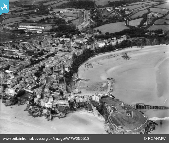
WPW055518 WALES (1937). General view of Tenby, oblique aerial view. 5"x4" black and white glass plate negative.
© Hawlfraint cyfranwyr OpenStreetMap a thrwyddedwyd gan yr OpenStreetMap Foundation. 2026. Trwyddedir y gartograffeg fel CC BY-SA.
Delweddau cyfagos (33)
Manylion
| Pennawd | [WPW055518] General view of Tenby, oblique aerial view. 5"x4" black and white glass plate negative. |
| Cyfeirnod | WPW055518 |
| Dyddiad | 22-September-1937 |
| Dolen | Coflein Archive Item 6370172 |
| Enw lle | |
| Plwyf | |
| Ardal | |
| Gwlad | WALES |
| Dwyreiniad / Gogleddiad | 213466, 200437 |
| Hydred / Lledred | -4.6979249577763, 51.671225629838 |
| Cyfeirnod Grid Cenedlaethol | SN135004 |
Pinnau

ricnic |
Monday 8th of October 2012 11:02:59 PM | |

ricnic |
Monday 8th of October 2012 10:59:18 PM | |

ricnic |
Monday 8th of October 2012 10:57:02 PM | |

ricnic |
Monday 8th of October 2012 10:26:58 PM | |

ricnic |
Monday 8th of October 2012 10:20:49 PM | |

ricnic |
Monday 8th of October 2012 10:18:30 PM | |

ricnic |
Monday 8th of October 2012 10:14:55 PM | |

ricnic |
Monday 8th of October 2012 10:08:37 PM | |

annr |
Sunday 26th of August 2012 08:14:29 PM |
Cyfraniadau Grŵp
I think this picture is around the mid 1930's . We live in a house in the road at the top of the picture where houses are being constructed by a builder called Griffiths, He has the reputation of introducing red brick in to the town a material he used when working in the SE of England ( we are told). Most houses in Pembrokeshire were built with stone or blocks. |

philbr |
Friday 29th of June 2012 09:33:40 PM |


![[WAW033700] General view of Tenby](http://britainfromabove.org.uk/sites/all/libraries/aerofilms-images/public/100x100/WAW/033/WAW033700.jpg)
![[WAW033701] General view of Tenby](http://britainfromabove.org.uk/sites/all/libraries/aerofilms-images/public/100x100/WAW/033/WAW033701.jpg)
![[WAW033702] General view of Tenby](http://britainfromabove.org.uk/sites/all/libraries/aerofilms-images/public/100x100/WAW/033/WAW033702.jpg)
![[WAW039181] View of Tenby showing Castle Hill & St Catherines Island](http://britainfromabove.org.uk/sites/all/libraries/aerofilms-images/public/100x100/WAW/039/WAW039181.jpg)
![[WAW039182] View of Tenby showing South Sands and Esplanade](http://britainfromabove.org.uk/sites/all/libraries/aerofilms-images/public/100x100/WAW/039/WAW039182.jpg)
![[WAW039183] View of Tenby showing town, including Ace's cycle and motor shop](http://britainfromabove.org.uk/sites/all/libraries/aerofilms-images/public/100x100/WAW/039/WAW039183.jpg)
![[WAW039184] General view of Tenby](http://britainfromabove.org.uk/sites/all/libraries/aerofilms-images/public/100x100/WAW/039/WAW039184.jpg)
![[WAW039185] General view of Tenby](http://britainfromabove.org.uk/sites/all/libraries/aerofilms-images/public/100x100/WAW/039/WAW039185.jpg)
![[WAW039186] View of Tenby showing castle hill and lifeboat station](http://britainfromabove.org.uk/sites/all/libraries/aerofilms-images/public/100x100/WAW/039/WAW039186.jpg)
![[WAW039187] View of Tenby showing castle hill and lifeboat station](http://britainfromabove.org.uk/sites/all/libraries/aerofilms-images/public/100x100/WAW/039/WAW039187.jpg)
![[WAW039188] View of Tenby](http://britainfromabove.org.uk/sites/all/libraries/aerofilms-images/public/100x100/WAW/039/WAW039188.jpg)
![[WAW039189] View of Tenby showing fort on St Catherines Island](http://britainfromabove.org.uk/sites/all/libraries/aerofilms-images/public/100x100/WAW/039/WAW039189.jpg)
![[WPW006971] View of Tenby, oblique aerial view. 5"x4" black and white glass plate negative.](http://britainfromabove.org.uk/sites/all/libraries/aerofilms-images/public/100x100/WPW/006/WPW006971.jpg)
![[WPW006972] View of Tenby, oblique aerial view. 5"x4" black and white glass plate negative.](http://britainfromabove.org.uk/sites/all/libraries/aerofilms-images/public/100x100/WPW/006/WPW006972.jpg)
![[WPW006973] View of Tenby, oblique aerial view. 5"x4" black and white glass plate negative.](http://britainfromabove.org.uk/sites/all/libraries/aerofilms-images/public/100x100/WPW/006/WPW006973.jpg)
![[WPW006974] View of Tenby, oblique aerial view. 5"x4" black and white glass plate negative.](http://britainfromabove.org.uk/sites/all/libraries/aerofilms-images/public/100x100/WPW/006/WPW006974.jpg)
![[WPW029669] General view of Tenby, oblique aerial view. 5"x4" black and white glass plate negative.](http://britainfromabove.org.uk/sites/all/libraries/aerofilms-images/public/100x100/WPW/029/WPW029669.jpg)
![[WPW029697] General view of Tenby showing the Esplanade. Oblique aerial photograph, 5"x4" BW glass plate.](http://britainfromabove.org.uk/sites/all/libraries/aerofilms-images/public/100x100/WPW/029/WPW029697.jpg)
![[WPW029699] View of Tenby showing newly constructed South Beach Pavilion. Oblique aerial photograph, 5"x4" BW glass plate.](http://britainfromabove.org.uk/sites/all/libraries/aerofilms-images/public/100x100/WPW/029/WPW029699.jpg)
![[WPW029701] View of Tenby Harbour, Castle Hill and St. Catherines Rocks, oblique aerial view. 5"x4" black and white glass plate negative.](http://britainfromabove.org.uk/sites/all/libraries/aerofilms-images/public/100x100/WPW/029/WPW029701.jpg)
![[WPW029702] General view of Tenby, the Esplanade, oblique aerial view. 5"x4" black and white glass plate negative.](http://britainfromabove.org.uk/sites/all/libraries/aerofilms-images/public/100x100/WPW/029/WPW029702.jpg)
![[WPW029709] View of Tenby showing North Beach. Oblique aerial photograph, 5"x4" BW glass plate.](http://britainfromabove.org.uk/sites/all/libraries/aerofilms-images/public/100x100/WPW/029/WPW029709.jpg)
![[WPW055513] General view of Tenby, oblique aerial view. 5"x4" black and white glass plate negative.](http://britainfromabove.org.uk/sites/all/libraries/aerofilms-images/public/100x100/WPW/055/WPW055513.jpg)
![[WPW055514] General view of Tenby, showing St Catherines Island, oblique aerial view. 5"x4" black and white glass plate negative.](http://britainfromabove.org.uk/sites/all/libraries/aerofilms-images/public/100x100/WPW/055/WPW055514.jpg)
![[WPW055515] General view of Tenby, oblique aerial view. 5"x4" black and white glass plate negative.](http://britainfromabove.org.uk/sites/all/libraries/aerofilms-images/public/100x100/WPW/055/WPW055515.jpg)
![[WPW055516] Distant view of Tenby, oblique aerial view. 5"x4" black and white glass plate negative.](http://britainfromabove.org.uk/sites/all/libraries/aerofilms-images/public/100x100/WPW/055/WPW055516.jpg)
![[WPW055517] General view of Tenby, oblique aerial view. 5"x4" black and white glass plate negative.](http://britainfromabove.org.uk/sites/all/libraries/aerofilms-images/public/100x100/WPW/055/WPW055517.jpg)
![[WPW055518] General view of Tenby, oblique aerial view. 5"x4" black and white glass plate negative.](http://britainfromabove.org.uk/sites/all/libraries/aerofilms-images/public/100x100/WPW/055/WPW055518.jpg)
![[WPW055519] General view of Tenby, oblique aerial view. 5"x4" black and white glass plate negative.](http://britainfromabove.org.uk/sites/all/libraries/aerofilms-images/public/100x100/WPW/055/WPW055519.jpg)
![[WAW039190] View of the Royal Gate House Hotel, Tenby](http://britainfromabove.org.uk/sites/all/libraries/aerofilms-images/public/100x100/WAW/039/WAW039190.jpg)
![[WAW039191] View of the Royal Gate House Hotel, Tenby](http://britainfromabove.org.uk/sites/all/libraries/aerofilms-images/public/100x100/WAW/039/WAW039191.jpg)
![[WAW039192] View of the Royal Gate House Hotel, Tenby](http://britainfromabove.org.uk/sites/all/libraries/aerofilms-images/public/100x100/WAW/039/WAW039192.jpg)
![[WAW039193] View of the Royal Gate House Hotel, Tenby](http://britainfromabove.org.uk/sites/all/libraries/aerofilms-images/public/100x100/WAW/039/WAW039193.jpg)