
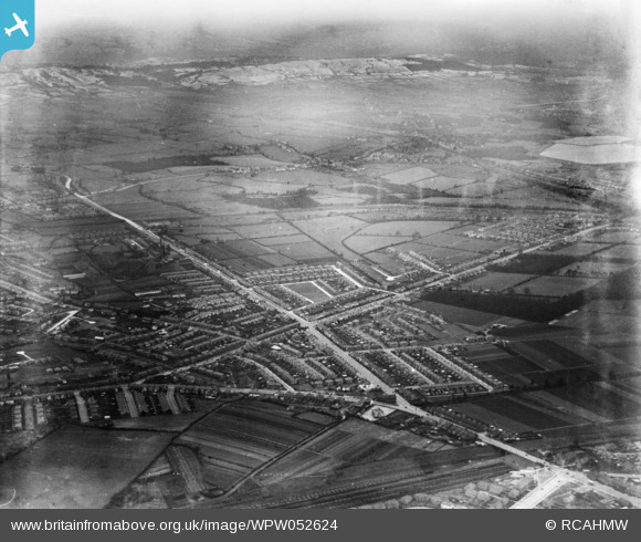
WPW052624 WALES (1937). Distant view of new housing at Llanishen near Cardiff, oblique aerial view. 5"x4" black and white glass plate negative.
© Hawlfraint cyfranwyr OpenStreetMap a thrwyddedwyd gan yr OpenStreetMap Foundation. 2026. Trwyddedir y gartograffeg fel CC BY-SA.
Delweddau cyfagos (48)
WPW001000

WPW001001

WPW001002

WPW001003

WPW001004

WPW001008

WPW001009

WPW001010

WPW001014

WPW001035

WPW016914

WPW016915

WPW016916

WPW016917

WPW016918

WPW016919

WPW016920

WPW029422

WPW029423

WPW029424

WPW029425

WPW029427

WPW029429

WPW041787

WPW041788

WPW041789

WPW041790

WPW041791

WPW041792

WPW041793

WPW041794

WPW041795

WPW052624

WPW052659

WPW052660

WPW052661

WPW052662

WPW052663

WPW052664

WPW054861

WPW054863

WPW054864

WPW054865

WPW055450

WPW055451

WPW055452

WPW055453

WPW055454

Manylion
| Pennawd | [WPW052624] Distant view of new housing at Llanishen near Cardiff, oblique aerial view. 5"x4" black and white glass plate negative. |
| Cyfeirnod | WPW052624 |
| Dyddiad | 1937 |
| Dolen | Coflein Archive Item 6370046 |
| Enw lle | |
| Plwyf | |
| Ardal | |
| Gwlad | WALES |
| Dwyreiniad / Gogleddiad | 318170, 176360 |
| Hydred / Lledred | -3.1785006478589, 51.479784917149 |
| Cyfeirnod Grid Cenedlaethol | ST182764 |
Pinnau

Steve |
Tuesday 16th of November 2021 07:47:57 PM | |
|
Heather Ward |
Saturday 13th of October 2018 09:05:13 PM | |
|
Heather Ward |
Saturday 13th of October 2018 09:03:55 PM | |
|
ERICA |
Thursday 19th of July 2012 07:06:06 PM | |
I think this is a farm once known as "Llwyn-crwn-Ganol Farm" on Oakridge West, Thornhill, Cardiff (at the junction iwth Heol Hir). The farm house is now known as Upper Mill House. Heol Hir farm is seperate and is currently part of Llanishen Golf Course. The photo marker is further south, to the west of Llywn-crwn-Ganol Wood (the wood that Pinecrest Drive/Excalibur drive backs on to). Also features here: http://www.britainfromabove.org.uk/image/wpw052628?quicktabs_image=0#comment-637569 |
Rob |
Monday 30th of December 2013 01:36:48 PM |
Yes you could be right Rob my memory does not serve me well regarding the name of the farm. Back in the 60's it was a farm on Heol Hir and beyond that where Thornhill School now stands was an echo gate. Farm still there but now hidden with houses. Happy memories of childhood. |
ERICA |
Friday 2nd of September 2016 07:45:36 PM |
|
JP1000 |
Thursday 28th of June 2012 04:01:17 PM | |
|
JP1000 |
Thursday 28th of June 2012 04:00:54 PM | |
|
JP1000 |
Thursday 28th of June 2012 03:59:38 PM | |
|
JP1000 |
Thursday 28th of June 2012 03:51:17 PM | |
|
AMSW |
Wednesday 27th of June 2012 10:14:47 PM | |
|
AMSW |
Wednesday 27th of June 2012 10:13:36 PM | |
My first skool! |
JP1000 |
Thursday 28th of June 2012 04:01:55 PM |
|
AMSW |
Wednesday 27th of June 2012 10:12:47 PM | |
Used to be the Cross Inn if I remember correctly |
JP1000 |
Thursday 28th of June 2012 10:01:03 PM |
|
peterg |
Wednesday 27th of June 2012 07:29:44 AM |