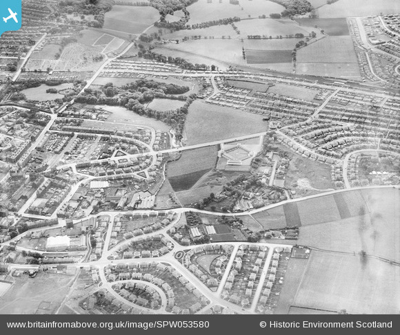
SPW053580 SCOTLAND (1937) [Unlocated]. Unlocated townscape, possibly in Glasgow. An oblique aerial photograph. This image has been produced from a print.
    © Hawlfraint cyfranwyr OpenStreetMap a thrwyddedwyd gan yr OpenStreetMap Foundation. 2025. Trwyddedir y gartograffeg fel CC BY-SA.
  
Delweddau cyfagos (48)
Manylion
| Pennawd | [SPW053580] Unlocated townscape, possibly in Glasgow. An oblique aerial photograph. This image has been produced from a print. | 
| Cyfeirnod | SPW053580 | 
| Dyddiad | 1937 | 
| Dolen | NRHE Collection item 1315611 | 
| Enw lle | |
| Plwyf | |
| Ardal | |
| Gwlad | SCOTLAND | 
| Dwyreiniad / Gogleddiad | 0, 0 | 
| Hydred / Lledred | -7.556448482059, 49.766185796754 | 
| Cyfeirnod Grid Cenedlaethol | SV000000 | 
Pinnau
|  Kingsbridge Drive |   Bankhead | Saturday 2nd of August 2014 12:49:16 AM | 
|  Crosshill House |   Bankhead | Saturday 2nd of August 2014 12:48:04 AM | 
|  Croftfoot Shops
We knew this area as the 4A |   olddobson | Monday 4th of November 2013 02:42:53 PM | 
|  Croftfoot Farm |   olddobson | Monday 4th of November 2013 02:41:28 PM | 
|  Mill Street Bridge. Glasgow to Kirkhill Railway |   olddobson | Saturday 14th of September 2013 04:55:39 PM | 
|   olddobson | Saturday 14th of September 2013 08:24:59 AM | |
|  Overtoun Drive |   olddobson | Saturday 24th of August 2013 07:09:47 AM | 
|  Clincarthill Road |   olddobson | Saturday 24th of August 2013 07:08:28 AM | 
|  Johnstone Drive |   olddobson | Saturday 24th of August 2013 07:06:59 AM | 
|  Farie Street School (St.Columbkilles Primary) |   olddobson | Saturday 24th of August 2013 06:52:25 AM | 
|  The Old Quarry Bar |   olddobson | Friday 23rd of August 2013 08:44:43 PM | 
|  Burnhill Tavern |   olddobson | Friday 23rd of August 2013 08:42:08 PM | 
|  Gate House to Dr.Quigley's Estate |   olddobson | Friday 23rd of August 2013 05:24:23 PM | 
|  Dr.Quigley's House |   olddobson | Friday 23rd of August 2013 05:21:56 PM | 
|  Overtoun Park |   olddobson | Friday 23rd of August 2013 05:16:12 PM | 
|  Castlemilk Road |   olddobson | Friday 23rd of August 2013 05:14:27 PM | 
|  Broomieknow Road |   olddobson | Friday 23rd of August 2013 05:10:49 PM | 
|  Rodger Drive |   olddobson | Friday 23rd of August 2013 05:08:23 PM | 
|  My House (Roughly) |   olddobson | Friday 23rd of August 2013 03:06:51 PM | 
|  Gatehouse to Castlemilk House |   olddobson | Friday 23rd of August 2013 02:59:22 PM | 
|  Spittal Farm |   olddobson | Friday 23rd of August 2013 02:56:47 PM | 
|  Mill Street |   olddobson | Friday 23rd of August 2013 02:41:04 PM | 
|  Bankhead Primary School |   olddobson | Friday 23rd of August 2013 02:39:46 PM | 
|  The Paddling Pond |   olddobson | Friday 23rd of August 2013 02:38:46 PM | 
|  Mitchell's Farm |   olddobson | Friday 23rd of August 2013 02:37:35 PM | 
|  Cemetery |   Sarah | Monday 8th of July 2013 06:28:50 PM | 
|  Croftfoot station |   Sarah | Monday 8th of July 2013 05:45:19 PM | 
|  Croftfoot Road |   Sarah | Monday 8th of July 2013 05:44:47 PM | 
|  Bankhead Road. |   Sarah | Monday 8th of July 2013 05:44:04 PM | 
|  Gilmore Crescent |   Sarah | Monday 8th of July 2013 05:43:10 PM | 
|  King's Park Avenue |   Sarah | Monday 8th of July 2013 05:31:28 PM | 
|  Blairbeth Road |   Sarah | Monday 8th of July 2013 05:30:31 PM | 
Cyfraniadau Grŵp
| Rutherglen, Glasgow looking south (and slightly east). Croftfoot Road at the top of the photograph; Pinkerton Avenue and Gilmore Crescent in the foreground. |   Sarah | Monday 8th of July 2013 05:42:34 PM | 
 
             
  ![[EPW000143] UNLOCATED](http://britainfromabove.org.uk/sites/all/libraries/aerofilms-images/public/100x100/EPW/000/EPW000143.jpg) 
  
                                          ![[EPW000667] Vessel at Sea](http://britainfromabove.org.uk/sites/all/libraries/aerofilms-images/public/100x100/EPW/000/EPW000667.jpg) 
 ![[EPW005260] UNLOCATED](http://britainfromabove.org.uk/sites/all/libraries/aerofilms-images/public/100x100/EPW/005/EPW005260.jpg) 
 ![[EPW006389] The R33 airship in flight over the Epsom Downs (unlocated), 1921](http://britainfromabove.org.uk/sites/all/libraries/aerofilms-images/public/100x100/EPW/006/EPW006389.jpg) 
 ![[EPW007181] UNLOCATED](http://britainfromabove.org.uk/sites/all/libraries/aerofilms-images/public/100x100/EPW/007/EPW007181.jpg) 
 ![[EPW015853] Cloudscape, 1926](http://britainfromabove.org.uk/sites/all/libraries/aerofilms-images/public/100x100/EPW/015/EPW015853.jpg) 
 ![[EPW015854] Cloudscape, 1926](http://britainfromabove.org.uk/sites/all/libraries/aerofilms-images/public/100x100/EPW/015/EPW015854.jpg) 
 ![[EPW015855] Cloudscape, 1926](http://britainfromabove.org.uk/sites/all/libraries/aerofilms-images/public/100x100/EPW/015/EPW015855.jpg) 
 ![[EPW016012] UNLOCATED](http://britainfromabove.org.uk/sites/all/libraries/aerofilms-images/public/100x100/EPW/016/EPW016012.jpg) 
 ![[EPW016510] Cloudscape, 1926](http://britainfromabove.org.uk/sites/all/libraries/aerofilms-images/public/100x100/EPW/016/EPW016510.jpg) 
 ![[EPW016641] EPW016641](http://britainfromabove.org.uk/sites/all/libraries/aerofilms-images/public/100x100/EPW/016/EPW016641.jpg) 
 ![[EPW017028] Cloudscape, 1926](http://britainfromabove.org.uk/sites/all/libraries/aerofilms-images/public/100x100/EPW/017/EPW017028.jpg) 
 ![[EPW017029] Cloudscape, 1926](http://britainfromabove.org.uk/sites/all/libraries/aerofilms-images/public/100x100/EPW/017/EPW017029.jpg) 
 ![[EPW017136] A vessel at sea off Beachy Head, from the east, 1926](http://britainfromabove.org.uk/sites/all/libraries/aerofilms-images/public/100x100/EPW/017/EPW017136.jpg) 
 ![[SAW003585] Skiddaw, Lake District.  Oblique aerial photograph.](http://britainfromabove.org.uk/sites/all/libraries/aerofilms-images/public/100x100/SAW/003/SAW003585.jpg) 
 ![[SAW003586] Unlocated mountains, possibly near Ben Nevis.  An oblique aerial photograph.](http://britainfromabove.org.uk/sites/all/libraries/aerofilms-images/public/100x100/SAW/003/SAW003586.jpg) 
 ![[SAW009337] Wigtown Bay, general view, showing Ringdoo Point.  An oblique aerial photograph taken facing west.](http://britainfromabove.org.uk/sites/all/libraries/aerofilms-images/public/100x100/SAW/009/SAW009337.jpg) 
 ![[SAW009800] Clouds.  An oblique aerial photograph.](http://britainfromabove.org.uk/sites/all/libraries/aerofilms-images/public/100x100/SAW/009/SAW009800.jpg) 
 ![[SAW009801] Clouds.  An oblique aerial photograph.](http://britainfromabove.org.uk/sites/all/libraries/aerofilms-images/public/100x100/SAW/009/SAW009801.jpg) 
 ![[SAW009802] Unlocated, Scotland, 1947. An oblique Aerial photograph.](http://britainfromabove.org.uk/sites/all/libraries/aerofilms-images/public/100x100/SAW/009/SAW009802.jpg) 
 ![[SAW010734] Clouds.  An oblique aerial photograph.](http://britainfromabove.org.uk/sites/all/libraries/aerofilms-images/public/100x100/SAW/010/SAW010734.jpg) 
 ![[SAW014737] Dalliefour Wood and River Dee, Balmoral Estate.  An oblique aerial photograph taken facing east.](http://britainfromabove.org.uk/sites/all/libraries/aerofilms-images/public/100x100/SAW/014/SAW014737.jpg) 
 ![[SAW017926] Unlocated image of haymaking, Dunbartonshire.  An oblique aerial photograph.](http://britainfromabove.org.uk/sites/all/libraries/aerofilms-images/public/100x100/SAW/017/SAW017926.jpg) 
 ![[SAW017927] Loch Ard  Forest, general view showing Beinn Bhreac, Loch Ard and Ben Venue. An oblique aerial photograph taken facing north-east. This image has been produced from a damaged negative.](http://britainfromabove.org.uk/sites/all/libraries/aerofilms-images/public/100x100/SAW/017/SAW017927.jpg) 
 ![[SAW032504] Unlocated country house, possibly near Ardanaiseig.  Oblique aerial photograph.  This image has been produced from a crop marked negative.](http://britainfromabove.org.uk/sites/all/libraries/aerofilms-images/public/100x100/SAW/032/SAW032504.jpg) 
 ![[SPW020275] Scottish Dyes Ltd. Works, Grangemouth.  An oblique aerial photograph taken facing north-west.](http://britainfromabove.org.uk/sites/all/libraries/aerofilms-images/public/100x100/SPW/020/SPW020275.jpg) 
 ![[SPW020280] Birds flying low between Grangemouth and Culross, Firth of Forth.  An oblique aerial photograph.](http://britainfromabove.org.uk/sites/all/libraries/aerofilms-images/public/100x100/SPW/020/SPW020280.jpg) 
 ![[SPW020281] Birds flying low between Grangemouth and Culross, Firth of Forth.  An oblique aerial photograph.](http://britainfromabove.org.uk/sites/all/libraries/aerofilms-images/public/100x100/SPW/020/SPW020281.jpg) 
 ![[SPW020284] Ochil Hills, general view, showing Carsebreck Loch and Lower and Upper Rhynd Reservoirs.  An oblique aerial photograph taken facing north-west.](http://britainfromabove.org.uk/sites/all/libraries/aerofilms-images/public/100x100/SPW/020/SPW020284.jpg) 
 ![[SPW020632] Unlocated moorland.  An oblique aerial photograph.](http://britainfromabove.org.uk/sites/all/libraries/aerofilms-images/public/100x100/SPW/020/SPW020632.jpg) 
 ![[SPW020633] Unlocated moorland.  An oblique aerial photograph.](http://britainfromabove.org.uk/sites/all/libraries/aerofilms-images/public/100x100/SPW/020/SPW020633.jpg) 
 ![[SPW027083] Unlocated hills in Peeblesshire.  An oblique aerial photograph.](http://britainfromabove.org.uk/sites/all/libraries/aerofilms-images/public/100x100/SPW/027/SPW027083.jpg) 
 ![[SPW049776] Queen Mary, Firth of Clyde.  An oblique aerial photograph.](http://britainfromabove.org.uk/sites/all/libraries/aerofilms-images/public/100x100/SPW/049/SPW049776.jpg) 
 ![[SPW049777] Queen Mary, Firth of Clyde.  An oblique aerial photograph.](http://britainfromabove.org.uk/sites/all/libraries/aerofilms-images/public/100x100/SPW/049/SPW049777.jpg) 
 ![[SPW049779] Queen Mary, Firth of Clyde.  An oblique aerial photograph.](http://britainfromabove.org.uk/sites/all/libraries/aerofilms-images/public/100x100/SPW/049/SPW049779.jpg) 
 ![[SPW049783] Queen Mary, Firth of Clyde.  An oblique aerial photograph.](http://britainfromabove.org.uk/sites/all/libraries/aerofilms-images/public/100x100/SPW/049/SPW049783.jpg) 
 ![[SPW049791] Queen Mary, River Clyde.  An oblique aerial photograph.](http://britainfromabove.org.uk/sites/all/libraries/aerofilms-images/public/100x100/SPW/049/SPW049791.jpg) 
 ![[SPW049798] Queen Mary, Firth of Clyde.  An oblique aerial photograph.](http://britainfromabove.org.uk/sites/all/libraries/aerofilms-images/public/100x100/SPW/049/SPW049798.jpg) 
 ![[SPW049801] Queen Mary, Firth of Clyde.  An oblique aerial photograph.](http://britainfromabove.org.uk/sites/all/libraries/aerofilms-images/public/100x100/SPW/049/SPW049801.jpg) 
 ![[SPW049827] Queen Mary, Firth of Clyde.  Speed trials.  An oblique aerial photograph.  This image has been produced from a damaged negative.](http://britainfromabove.org.uk/sites/all/libraries/aerofilms-images/public/100x100/SPW/049/SPW049827.jpg) 
 ![[SPW049828] Queen Mary, Firth of Clyde.  Speed trials.  An oblique aerial photograph.  This image has been produced from a damaged negative.](http://britainfromabove.org.uk/sites/all/libraries/aerofilms-images/public/100x100/SPW/049/SPW049828.jpg) 
 ![[SPW049831] Queen Mary, Firth of Clyde.  Speed trials.  An oblique aerial photograph.  This image has been produced from a damaged negative.](http://britainfromabove.org.uk/sites/all/libraries/aerofilms-images/public/100x100/SPW/049/SPW049831.jpg) 
 ![[SPW049832] Queen Mary, Firth of Clyde.  Speed trials.  An oblique aerial photograph.](http://britainfromabove.org.uk/sites/all/libraries/aerofilms-images/public/100x100/SPW/049/SPW049832.jpg) 
 ![[SPW049834] Queen Mary, Firth of Clyde.  Speed trials.  An oblique aerial photograph.](http://britainfromabove.org.uk/sites/all/libraries/aerofilms-images/public/100x100/SPW/049/SPW049834.jpg) 
 ![[SPW049948] Queen Mary, Firth of Clyde.  Speed trials.  An oblique aerial photograph.](http://britainfromabove.org.uk/sites/all/libraries/aerofilms-images/public/100x100/SPW/049/SPW049948.jpg) 
 ![[SPW049949] Queen Mary, Firth of Clyde.  Speed trials.  An oblique aerial photograph.](http://britainfromabove.org.uk/sites/all/libraries/aerofilms-images/public/100x100/SPW/049/SPW049949.jpg) 
 ![[SPW051009] Unlocated area within the Glenapp Estate.  An oblique aerial photograph.](http://britainfromabove.org.uk/sites/all/libraries/aerofilms-images/public/100x100/SPW/051/SPW051009.jpg) 
 ![[SPW062638] Unlocated countryside.  An oblique aerial photograph.](http://britainfromabove.org.uk/sites/all/libraries/aerofilms-images/public/100x100/SPW/062/SPW062638.jpg) 
 