
SPW042560 SCOTLAND (1933) [Unlocated]
© Hawlfraint cyfranwyr OpenStreetMap a thrwyddedwyd gan yr OpenStreetMap Foundation. 2026. Trwyddedir y gartograffeg fel CC BY-SA.
Delweddau cyfagos (48)
EPW000143

EPW000667

EPW005260

EPW006389
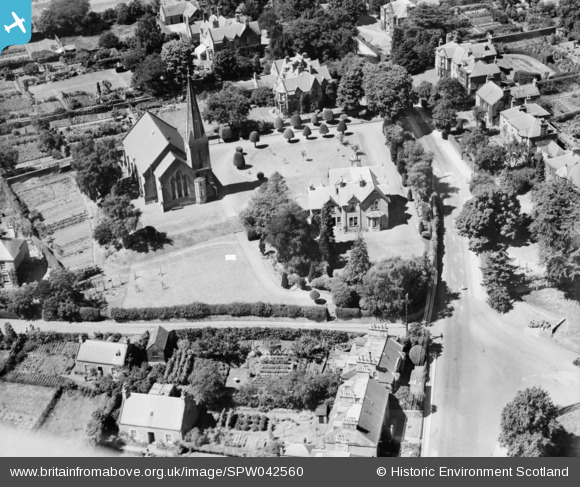
, 1921")
EPW007181

EPW015853

EPW015854

EPW015855

EPW016012

EPW016510

EPW016641

EPW017028

EPW017029

EPW017136

SAW003585

SAW003586

SAW009337

SAW009800

SAW009801

SAW009802

SAW010734

SAW014737

SAW017926

SAW017927

SAW032504

SPW020275

SPW020280

SPW020281

SPW020284

SPW020632

SPW020633

SPW027083

SPW049776

SPW049777

SPW049779

SPW049783

SPW049791

SPW049798

SPW049801

SPW049827

SPW049828

SPW049831

SPW049832

SPW049834

SPW049948

SPW049949

SPW051009

SPW062638

Manylion
| Pennawd | SPW042560 |
| Cyfeirnod | SPW042560 |
| Dyddiad | July-1933 |
| Dolen | |
| Enw lle | |
| Plwyf | |
| Ardal | |
| Gwlad | SCOTLAND |
| Dwyreiniad / Gogleddiad | 0, 0 |
| Hydred / Lledred | -2.7260204053053, 55.599132689885 |
| Cyfeirnod Grid Cenedlaethol | NT543342 |
Pinnau

Chris Willis |
Saturday 22nd of June 2013 05:28:07 PM | |
|
Chris Willis |
Saturday 22nd of June 2013 05:26:35 PM | |
|
Chris Willis |
Saturday 22nd of June 2013 05:24:41 PM | |
|
adfbristol |
Wednesday 19th of June 2013 11:23:25 PM | |
|
adfbristol |
Wednesday 19th of June 2013 11:01:10 PM | |
|
Chris Willis |
Tuesday 14th of May 2013 02:45:59 PM | |
|
Chris Willis |
Tuesday 14th of May 2013 11:31:06 AM | |
On 1921 1:2500 as St Aidan U. P. Church. The NE tower which supports the broach spire shows on the map |
Chris Willis |
Sunday 23rd of June 2013 03:00:51 PM |
|
Chris Willis |
Tuesday 14th of May 2013 11:23:23 AM |
Cyfraniadau Grŵp
Hullo everyone, Thanks for spending time on this photo. The original Aerofilms Ltd Register entry for this image is blank, so we had no idea which country it belongs to; default position is "England" because most of the collection is English. As we have to make changes to everything from the glass plate negative on the shelf to the catalogue and online record it will take longer to resolve, but nevertheless we're on it! Yours, Katy Britain from Above Cataloguing Team Leader |
Katy Whitaker |
Tuesday 2nd of July 2013 12:28:50 PM |
Hi adfbristol I've taken the liberty of tweaking your coordinate. I spent ages thinking that you thought the nearer church was Holy Trinity (which is alive and well). Eventually realised that that church was the one on the 1921 map described as St Aidan, U.P Church. I wasn't helped because the only map that gives a dedication to the parish church says St Cuthbert. I don't know if this is part of a double dedication, or just an error. |
Chris Willis |
Saturday 22nd of June 2013 05:23:13 PM |