
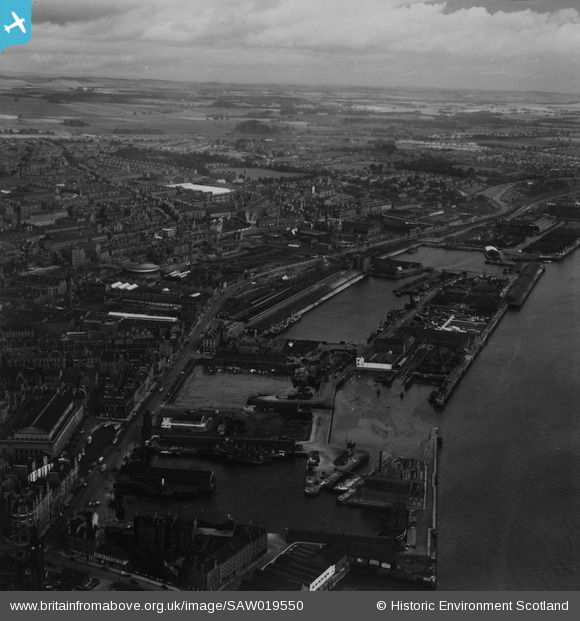
SAW019550 SCOTLAND (1948). Dundee, general view, showing King William IV Dock and East Dock Street. An oblique aerial photograph taken facing north-east. This image has been produced from a print.
© Hawlfraint cyfranwyr OpenStreetMap a thrwyddedwyd gan yr OpenStreetMap Foundation. 2026. Trwyddedir y gartograffeg fel CC BY-SA.
Delweddau cyfagos (11)
SAW019550

SPW022109

SPW022111

SPW040570

SAW014836

SPW019941

SPW019942

SAW019552

SAW009806

SAW014834

SPW022108

Manylion
| Pennawd | [SAW019550] Dundee, general view, showing King William IV Dock and East Dock Street. An oblique aerial photograph taken facing north-east. This image has been produced from a print. |
| Cyfeirnod | SAW019550 |
| Dyddiad | 1948 |
| Dolen | NRHE Collection item 1314942 |
| Enw lle | |
| Plwyf | DUNDEE (DUNDEE, CITY OF) |
| Ardal | CITY OF DUNDEE |
| Gwlad | SCOTLAND |
| Dwyreiniad / Gogleddiad | 340910, 730432 |
| Hydred / Lledred | -2.9590355956485, 56.462424340372 |
| Cyfeirnod Grid Cenedlaethol | NO409304 |
Pinnau
Byddwch y cyntaf i ychwanegu sylw at y ddelwedd hon!