
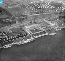
SPW019941 SCOTLAND (1927). Dundee, general view, showing Camperdown Dock and Queen Elizabeth Wharf. An oblique aerial photograph taken facing north-east.

© Hawlfraint cyfranwyr OpenStreetMap a thrwyddedwyd gan yr OpenStreetMap Foundation. 2026. Trwyddedir y gartograffeg fel CC BY-SA.
Delweddau cyfagos (12)
SPW019941

SPW019942

SPW019946

SPW022107

SPW022106

SPW040563

SPW022109

SPW022111

SPW019938

SPW019945

SAW019550

SAW019552

Manylion
| Pennawd | [SPW019941] Dundee, general view, showing Camperdown Dock and Queen Elizabeth Wharf. An oblique aerial photograph taken facing north-east. |
| Cyfeirnod | SPW019941 |
| Dyddiad | 1927 |
| Dolen | NRHE Collection item 1246345 |
| Enw lle | |
| Plwyf | DUNDEE (DUNDEE, CITY OF) |
| Ardal | CITY OF DUNDEE |
| Gwlad | SCOTLAND |
| Dwyreiniad / Gogleddiad | 341151, 730413 |
| Hydred / Lledred | -2.9551204766979, 56.462283795962 |
| Cyfeirnod Grid Cenedlaethol | NO412304 |
Pinnau
Cyfraniadau Grŵp
Stannergate Power Station also known as Caroline Port A, built by Dundee Corporation, opened 1909, taken over by the NSHEB in 1947, closed in 1960s?. Caroline Port B was built adjacent to this site. |

cell |
Monday 23rd of July 2012 08:28:32 PM |