
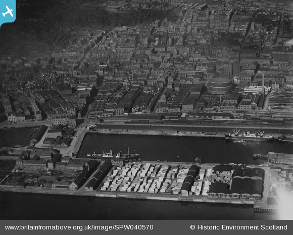
SPW040570 SCOTLAND (1932). Dundee, general view, showing Victoria Dock and Dundee Foundry. An oblique aerial photograph taken facing north. This image has been produced from a print.
© Hawlfraint cyfranwyr OpenStreetMap a thrwyddedwyd gan yr OpenStreetMap Foundation. 2026. Trwyddedir y gartograffeg fel CC BY-SA.
Delweddau cyfagos (11)
SPW040570

SAW014836

SAW019550

SAW019549

SAW009806

SAW014834

SPW022108

SPW022109

SPW022111

SPW019936

SAW019552

Manylion
| Pennawd | [SPW040570] Dundee, general view, showing Victoria Dock and Dundee Foundry. An oblique aerial photograph taken facing north. This image has been produced from a print. |
| Cyfeirnod | SPW040570 |
| Dyddiad | 1932 |
| Dolen | NRHE Collection item 1315561 |
| Enw lle | |
| Plwyf | DUNDEE (DUNDEE, CITY OF) |
| Ardal | CITY OF DUNDEE |
| Gwlad | SCOTLAND |
| Dwyreiniad / Gogleddiad | 340725, 730429 |
| Hydred / Lledred | -2.9620370019503, 56.462374162534 |
| Cyfeirnod Grid Cenedlaethol | NO407304 |
Pinnau

Stobieer |
Sunday 19th of January 2014 08:27:25 AM | |
|
Stobieer |
Sunday 19th of January 2014 08:23:51 AM | |
|
Stobieer |
Sunday 19th of January 2014 08:22:25 AM | |
|
Stobieer |
Sunday 19th of January 2014 08:17:54 AM | |
|
Stobieer |
Sunday 19th of January 2014 08:15:18 AM | |
|
Stobieer |
Sunday 19th of January 2014 08:14:08 AM |