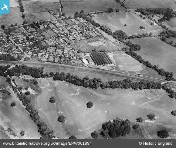
EPW061894 ENGLAND (1939). The Electrical Apparatus Co Ltd Works, the Verulam Golf Course and the surrounding residential area, St Albans, 1939
© Hawlfraint cyfranwyr OpenStreetMap a thrwyddedwyd gan yr OpenStreetMap Foundation. 2026. Trwyddedir y gartograffeg fel CC BY-SA.
Delweddau cyfagos (19)
Manylion
| Pennawd | [EPW061894] The Electrical Apparatus Co Ltd Works, the Verulam Golf Course and the surrounding residential area, St Albans, 1939 |
| Cyfeirnod | EPW061894 |
| Dyddiad | June-1939 |
| Dolen | |
| Enw lle | ST ALBANS |
| Plwyf | |
| Ardal | |
| Gwlad | ENGLAND |
| Dwyreiniad / Gogleddiad | 516170, 205457 |
| Hydred / Lledred | -0.31749261114585, 51.735311966395 |
| Cyfeirnod Grid Cenedlaethol | TL162055 |
Pinnau

John W |
Saturday 8th of February 2020 05:32:45 PM | |

John W |
Saturday 8th of February 2020 05:31:24 PM | |

John W |
Saturday 8th of February 2020 05:29:56 PM | |

John W |
Saturday 8th of February 2020 05:28:59 PM | |

John W |
Saturday 8th of February 2020 05:25:47 PM | |

John W |
Saturday 8th of February 2020 05:25:17 PM |


![[EPW061894] The Electrical Apparatus Co Ltd Works, the Verulam Golf Course and the surrounding residential area, St Albans, 1939](http://britainfromabove.org.uk/sites/all/libraries/aerofilms-images/public/100x100/EPW/061/EPW061894.jpg)
![[EPW061892] The Electrical Apparatus Co Ltd Works, the Verulam Golf Course and the surrounding area, St Albans, 1939](http://britainfromabove.org.uk/sites/all/libraries/aerofilms-images/public/100x100/EPW/061/EPW061892.jpg)
![[EPW060980] The Electrical Apparatus Co Works, St Albans, 1939](http://britainfromabove.org.uk/sites/all/libraries/aerofilms-images/public/100x100/EPW/060/EPW060980.jpg)
![[EPW061897] The Electrical Apparatus Co Ltd Works, St Albans, 1939](http://britainfromabove.org.uk/sites/all/libraries/aerofilms-images/public/100x100/EPW/061/EPW061897.jpg)
![[EPW061900] The Electrical Apparatus Co Ltd Works, St Albans, 1939](http://britainfromabove.org.uk/sites/all/libraries/aerofilms-images/public/100x100/EPW/061/EPW061900.jpg)
![[EPW061896] The Electrical Apparatus Co Ltd Works, St Albans, 1939](http://britainfromabove.org.uk/sites/all/libraries/aerofilms-images/public/100x100/EPW/061/EPW061896.jpg)
![[EPW061901] The Electrical Apparatus Co Ltd Works, St Albans, 1939](http://britainfromabove.org.uk/sites/all/libraries/aerofilms-images/public/100x100/EPW/061/EPW061901.jpg)
![[EPW061895] The Electrical Apparatus Co Ltd Works and the surrounding residential area, St Albans, 1939](http://britainfromabove.org.uk/sites/all/libraries/aerofilms-images/public/100x100/EPW/061/EPW061895.jpg)
![[EPW061893] The Electrical Apparatus Co Ltd Works, the Verulam Golf Course and the surrounding area, St Albans, 1939](http://britainfromabove.org.uk/sites/all/libraries/aerofilms-images/public/100x100/EPW/061/EPW061893.jpg)
![[EPW060976] The Electrical Apparatus Co Works, St Albans, 1939. This image has been produced from a copy-negative.](http://britainfromabove.org.uk/sites/all/libraries/aerofilms-images/public/100x100/EPW/060/EPW060976.jpg)
![[EPW061890] The Electrical Apparatus Co Ltd Works, the Verulam Golf Course and the surrounding residential area, St Albans, 1939. This image has been affected by flare.](http://britainfromabove.org.uk/sites/all/libraries/aerofilms-images/public/100x100/EPW/061/EPW061890.jpg)
![[EPW061899] The Electrical Apparatus Co Ltd Works and housing off New Barnes Avenue, St Albans, 1939](http://britainfromabove.org.uk/sites/all/libraries/aerofilms-images/public/100x100/EPW/061/EPW061899.jpg)
![[EPW061898] The Electrical Apparatus Co Ltd Works and housing off New Barnes Avenue, St Albans, 1939](http://britainfromabove.org.uk/sites/all/libraries/aerofilms-images/public/100x100/EPW/061/EPW061898.jpg)
![[EPW060974] The Electrical Apparatus Co Works, St Albans, 1939](http://britainfromabove.org.uk/sites/all/libraries/aerofilms-images/public/100x100/EPW/060/EPW060974.jpg)
![[EAW027916] The Electrical Apparatus Co Ltd Works, St Albans, 1950](http://britainfromabove.org.uk/sites/all/libraries/aerofilms-images/public/100x100/EAW/027/EAW027916.jpg)
![[EAW027915] The Electrical Apparatus Co Ltd Works, St Albans, 1950. This image has been produced from a damaged negative.](http://britainfromabove.org.uk/sites/all/libraries/aerofilms-images/public/100x100/EAW/027/EAW027915.jpg)
![[EPW061891] The Electrical Apparatus Co Ltd Works and the surrounding area, St Albans, 1939. This image has been affected by flare.](http://britainfromabove.org.uk/sites/all/libraries/aerofilms-images/public/100x100/EPW/061/EPW061891.jpg)
![[EPW061889] The Electrical Apparatus Co Ltd Works and the surrounding residential area, St Albans, 1939](http://britainfromabove.org.uk/sites/all/libraries/aerofilms-images/public/100x100/EPW/061/EPW061889.jpg)
![[EPW061888] The Electrical Apparatus Co Ltd Works and the surrounding area, St Albans, 1939](http://britainfromabove.org.uk/sites/all/libraries/aerofilms-images/public/100x100/EPW/061/EPW061888.jpg)