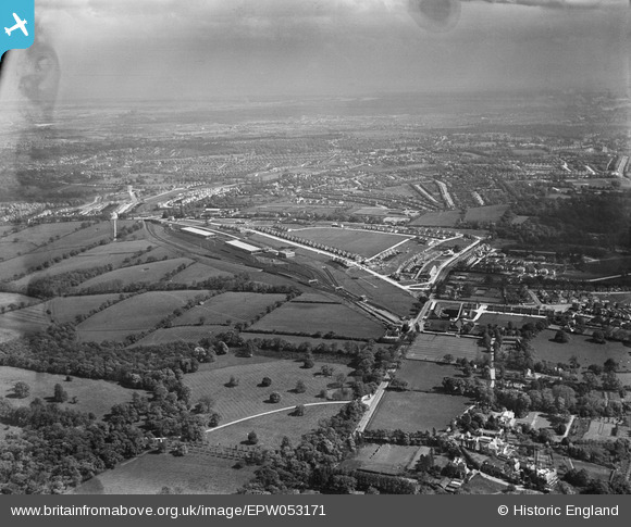
EPW053171 ENGLAND (1937). Cockfosters Road, the Piccadilly Line between Cockfosters and Enfield West (Oakwood) Underground Stations and environs, Cockfosters, from the north-west, 1937
© Hawlfraint cyfranwyr OpenStreetMap a thrwyddedwyd gan yr OpenStreetMap Foundation. 2026. Trwyddedir y gartograffeg fel CC BY-SA.
Manylion
| Pennawd | [EPW053171] Cockfosters Road, the Piccadilly Line between Cockfosters and Enfield West (Oakwood) Underground Stations and environs, Cockfosters, from the north-west, 1937 |
| Cyfeirnod | EPW053171 |
| Dyddiad | 21-May-1937 |
| Dolen | |
| Enw lle | COCKFOSTERS |
| Plwyf | |
| Ardal | |
| Gwlad | ENGLAND |
| Dwyreiniad / Gogleddiad | 528096, 196592 |
| Hydred / Lledred | -0.14811518746841, 51.653038796359 |
| Cyfeirnod Grid Cenedlaethol | TQ281966 |
Pinnau

Tilerman |
Monday 3rd of October 2022 02:17:40 PM | |

S00Z |
Sunday 24th of September 2017 10:21:33 AM | |

East Barnet Stan |
Sunday 30th of October 2016 06:18:20 PM | |

Macmartyn |
Monday 4th of November 2013 03:52:23 PM | |

Macmartyn |
Monday 4th of November 2013 03:51:01 PM | |

Macmartyn |
Monday 4th of November 2013 03:49:37 PM | |

Macmartyn |
Monday 4th of November 2013 03:48:46 PM | |

Macmartyn |
Monday 4th of November 2013 03:35:07 PM |


![[EPW053171] Cockfosters Road, the Piccadilly Line between Cockfosters and Enfield West (Oakwood) Underground Stations and environs, Cockfosters, from the north-west, 1937](http://britainfromabove.org.uk/sites/all/libraries/aerofilms-images/public/100x100/EPW/053/EPW053171.jpg)
![[EPW053172] Cockfosters Underground Station, the Piccadilly Line and environs, Cockfosters, from the north-west, 1937](http://britainfromabove.org.uk/sites/all/libraries/aerofilms-images/public/100x100/EPW/053/EPW053172.jpg)