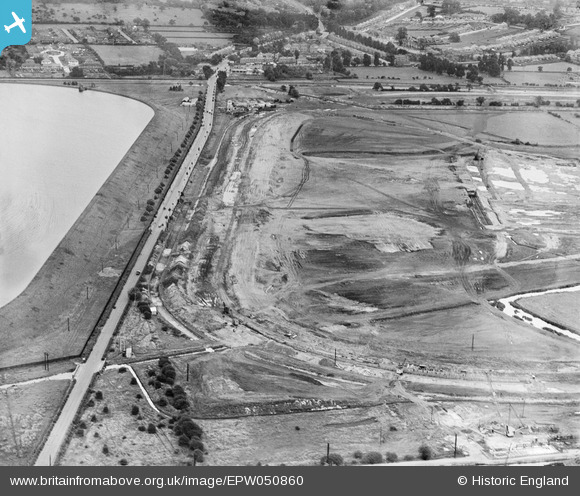
EPW050860 ENGLAND (1936). The site of the northern end of the William Girling Reservoir showing preliminary construction works, Ponders End, 1936
© Hawlfraint cyfranwyr OpenStreetMap a thrwyddedwyd gan yr OpenStreetMap Foundation. 2026. Trwyddedir y gartograffeg fel CC BY-SA.
Delweddau cyfagos (33)
Manylion
| Pennawd | [EPW050860] The site of the northern end of the William Girling Reservoir showing preliminary construction works, Ponders End, 1936 |
| Cyfeirnod | EPW050860 |
| Dyddiad | July-1936 |
| Dolen | |
| Enw lle | PONDERS END |
| Plwyf | |
| Ardal | |
| Gwlad | ENGLAND |
| Dwyreiniad / Gogleddiad | 536877, 195121 |
| Hydred / Lledred | -0.021822751944918, 51.637749326077 |
| Cyfeirnod Grid Cenedlaethol | TQ369951 |
Pinnau
Byddwch y cyntaf i ychwanegu sylw at y ddelwedd hon!


![[EPW050860] The site of the northern end of the William Girling Reservoir showing preliminary construction works, Ponders End, 1936](http://britainfromabove.org.uk/sites/all/libraries/aerofilms-images/public/100x100/EPW/050/EPW050860.jpg)
![[EPW053850] The northern part of the Chingford (William Girling) Reservoir under construction, Edmonton, 1937](http://britainfromabove.org.uk/sites/all/libraries/aerofilms-images/public/100x100/EPW/053/EPW053850.jpg)
![[EPW052275] The site of the northern end of the William Girling Reservoir showing preliminary construction works, Ponders End, 1936. This image has been produced from a damaged negative.](http://britainfromabove.org.uk/sites/all/libraries/aerofilms-images/public/100x100/EPW/052/EPW052275.jpg)
![[EPW060626] Lea Valley Road and the William Girling Reservoir under construction, Enfield, 1939](http://britainfromabove.org.uk/sites/all/libraries/aerofilms-images/public/100x100/EPW/060/EPW060626.jpg)
![[EPW055978] The northern section of the William Girling Reservoir under construction, Enfield, 1937](http://britainfromabove.org.uk/sites/all/libraries/aerofilms-images/public/100x100/EPW/055/EPW055978.jpg)
![[EPW056328] The northern end of the William Girling Reservoir under construction, Ponders End, 1938](http://britainfromabove.org.uk/sites/all/libraries/aerofilms-images/public/100x100/EPW/056/EPW056328.jpg)
![[EPW060638] Lea Valley Road, King George's Reservoir and the William Girling Reservoir under construction, Enfield, 1939](http://britainfromabove.org.uk/sites/all/libraries/aerofilms-images/public/100x100/EPW/060/EPW060638.jpg)
![[EPW060632] Lea Valley Road, King George's Reservoir and the William Girling Reservoir under construction, Enfield, 1939](http://britainfromabove.org.uk/sites/all/libraries/aerofilms-images/public/100x100/EPW/060/EPW060632.jpg)
![[EPW056330] The northern end of the William Girling Reservoir under construction, Ponders End, 1938](http://britainfromabove.org.uk/sites/all/libraries/aerofilms-images/public/100x100/EPW/056/EPW056330.jpg)
![[EPW055986] The northern section of the William Girling Reservoir under construction, Enfield, 1937](http://britainfromabove.org.uk/sites/all/libraries/aerofilms-images/public/100x100/EPW/055/EPW055986.jpg)
![[EPW053839] The northern part of the Chingford (William Girling) Reservoir under construction, Edmonton, 1937](http://britainfromabove.org.uk/sites/all/libraries/aerofilms-images/public/100x100/EPW/053/EPW053839.jpg)
![[EPW056826] The northern end of the William Girling Reservoir under construction, Ponders End, 1938](http://britainfromabove.org.uk/sites/all/libraries/aerofilms-images/public/100x100/EPW/056/EPW056826.jpg)
![[EPW049705] The site of the northern end of the William Girling Reservoir showing preliminary construction works, Ponders End, 1936](http://britainfromabove.org.uk/sites/all/libraries/aerofilms-images/public/100x100/EPW/049/EPW049705.jpg)
![[EPW058469] The northern part of the Chingford (William Girling) Reservoir under construction, Edmonton, 1938](http://britainfromabove.org.uk/sites/all/libraries/aerofilms-images/public/100x100/EPW/058/EPW058469.jpg)
![[EPW058455] The northern part of the Chingford (William Girling) Reservoir under construction, Edmonton, 1938](http://britainfromabove.org.uk/sites/all/libraries/aerofilms-images/public/100x100/EPW/058/EPW058455.jpg)
![[EPW055975] The northern section of the William Girling Reservoir under construction, Enfield, 1937](http://britainfromabove.org.uk/sites/all/libraries/aerofilms-images/public/100x100/EPW/055/EPW055975.jpg)
![[EPW053849] The northern part of the Chingford (William Girling) Reservoir under construction, Edmonton, 1937](http://britainfromabove.org.uk/sites/all/libraries/aerofilms-images/public/100x100/EPW/053/EPW053849.jpg)
![[EPW056819] The northern end of the William Girling Reservoir under construction, Ponders End, 1938](http://britainfromabove.org.uk/sites/all/libraries/aerofilms-images/public/100x100/EPW/056/EPW056819.jpg)
![[EPW060224] The Chingford (William Girling) Reservoir under construction, Edmonton, from the north, 1938](http://britainfromabove.org.uk/sites/all/libraries/aerofilms-images/public/100x100/EPW/060/EPW060224.jpg)
![[EPW060637] Lea Valley Road, King George's Reservoir and the William Girling Reservoir under construction, Enfield, 1939](http://britainfromabove.org.uk/sites/all/libraries/aerofilms-images/public/100x100/EPW/060/EPW060637.jpg)
![[EPW053842] The northern part of the Chingford (William Girling) Reservoir under construction, Edmonton, 1937. This image has been affected by flare.](http://britainfromabove.org.uk/sites/all/libraries/aerofilms-images/public/100x100/EPW/053/EPW053842.jpg)
![[EPW056827] The northern end of the William Girling Reservoir under construction, Ponders End, 1938](http://britainfromabove.org.uk/sites/all/libraries/aerofilms-images/public/100x100/EPW/056/EPW056827.jpg)
![[EPW050861] The site of the northern end of the William Girling Reservoir showing preliminary construction works, Ponders End, 1936](http://britainfromabove.org.uk/sites/all/libraries/aerofilms-images/public/100x100/EPW/050/EPW050861.jpg)
![[EPW052689] Construction of the William Girling Reservoir and environs, Enfield, 1937](http://britainfromabove.org.uk/sites/all/libraries/aerofilms-images/public/100x100/EPW/052/EPW052689.jpg)
![[EPW053845] The northern part of the Chingford (William Girling) Reservoir under construction, Edmonton, 1937](http://britainfromabove.org.uk/sites/all/libraries/aerofilms-images/public/100x100/EPW/053/EPW053845.jpg)
![[EPW049697] The site of the northern end of the William Girling Reservoir showing preliminary construction works, Ponders End, 1936](http://britainfromabove.org.uk/sites/all/libraries/aerofilms-images/public/100x100/EPW/049/EPW049697.jpg)
![[EPW049713] The site of the northern end of the William Girling Reservoir showing preliminary construction works, Ponders End, 1936](http://britainfromabove.org.uk/sites/all/libraries/aerofilms-images/public/100x100/EPW/049/EPW049713.jpg)
![[EPW049719] The site of the northern end of the William Girling Reservoir showing preliminary construction works, Ponders End, 1936](http://britainfromabove.org.uk/sites/all/libraries/aerofilms-images/public/100x100/EPW/049/EPW049719.jpg)
![[EPW058466] The northern part of the Chingford (William Girling) Reservoir under construction, Edmonton, 1938](http://britainfromabove.org.uk/sites/all/libraries/aerofilms-images/public/100x100/EPW/058/EPW058466.jpg)
![[EPW049704] The site of the northern end of the William Girling Reservoir showing preliminary construction works, Ponders End, 1936](http://britainfromabove.org.uk/sites/all/libraries/aerofilms-images/public/100x100/EPW/049/EPW049704.jpg)
![[EPW060220] The northern part of the Chingford (William Girling) Reservoir under construction, Edmonton, 1938](http://britainfromabove.org.uk/sites/all/libraries/aerofilms-images/public/100x100/EPW/060/EPW060220.jpg)
![[EPW052266] The site of the northern end of the William Girling Reservoir showing preliminary construction works, Ponders End, 1936](http://britainfromabove.org.uk/sites/all/libraries/aerofilms-images/public/100x100/EPW/052/EPW052266.jpg)
![[EPW048904] The southern end of King George's Reservoir, the Charlotte Cabinet Works and Lea Valley Road, Ponders End, 1935](http://britainfromabove.org.uk/sites/all/libraries/aerofilms-images/public/100x100/EPW/048/EPW048904.jpg)