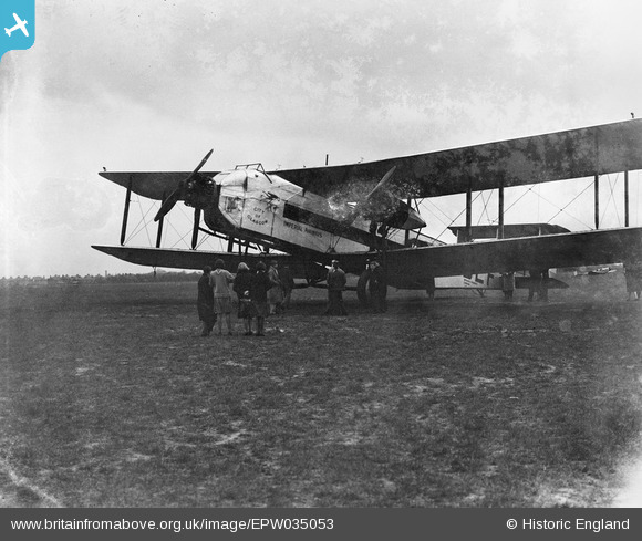
EPW035053 ENGLAND (1931) [Unlocated]. Imperial Airways Argosy 'City of Glasgow' (G-EBLF), 1931
    © Hawlfraint cyfranwyr OpenStreetMap a thrwyddedwyd gan yr OpenStreetMap Foundation. 2025. Trwyddedir y gartograffeg fel CC BY-SA.
  
Delweddau cyfagos (48)
Manylion
| Pennawd | [EPW035053] Imperial Airways Argosy 'City of Glasgow' (G-EBLF), 1931 | 
| Cyfeirnod | EPW035053 | 
| Dyddiad | May-1931 | 
| Dolen | |
| Enw lle | |
| Plwyf | |
| Ardal | |
| Gwlad | ENGLAND | 
| Dwyreiniad / Gogleddiad | 0, 0 | 
| Hydred / Lledred | -7.556448482059, 49.766185796754 | 
| Cyfeirnod Grid Cenedlaethol | SV000000 | 
Pinnau
|  Note the open cockpit |   Biggles1951 | Monday 20th of January 2014 09:22:18 AM | 
Cyfraniadau Grŵp
| Constructed by Armstrong Whitworth Aircraft, with three Jaguar IIIA engies, each rated at 385hp. City of Glasgow was one of three Mark Is; a further four Mark IIs were built with larger radial engines. Details of the Argosy on Wikipedia: en.wikipedia.org/wiki/Armstrong_Whitworth_Argosy |   MB | Monday 30th of December 2013 10:15:19 AM | 
 
             
  ![[EPW000143] UNLOCATED](http://britainfromabove.org.uk/sites/all/libraries/aerofilms-images/public/100x100/EPW/000/EPW000143.jpg) 
  
                                          ![[EPW000667] Vessel at Sea](http://britainfromabove.org.uk/sites/all/libraries/aerofilms-images/public/100x100/EPW/000/EPW000667.jpg) 
 ![[EPW005260] UNLOCATED](http://britainfromabove.org.uk/sites/all/libraries/aerofilms-images/public/100x100/EPW/005/EPW005260.jpg) 
 ![[EPW006389] The R33 airship in flight over the Epsom Downs (unlocated), 1921](http://britainfromabove.org.uk/sites/all/libraries/aerofilms-images/public/100x100/EPW/006/EPW006389.jpg) 
 ![[EPW007181] UNLOCATED](http://britainfromabove.org.uk/sites/all/libraries/aerofilms-images/public/100x100/EPW/007/EPW007181.jpg) 
 ![[EPW015853] Cloudscape, 1926](http://britainfromabove.org.uk/sites/all/libraries/aerofilms-images/public/100x100/EPW/015/EPW015853.jpg) 
 ![[EPW015854] Cloudscape, 1926](http://britainfromabove.org.uk/sites/all/libraries/aerofilms-images/public/100x100/EPW/015/EPW015854.jpg) 
 ![[EPW015855] Cloudscape, 1926](http://britainfromabove.org.uk/sites/all/libraries/aerofilms-images/public/100x100/EPW/015/EPW015855.jpg) 
 ![[EPW016012] UNLOCATED](http://britainfromabove.org.uk/sites/all/libraries/aerofilms-images/public/100x100/EPW/016/EPW016012.jpg) 
 ![[EPW016510] Cloudscape, 1926](http://britainfromabove.org.uk/sites/all/libraries/aerofilms-images/public/100x100/EPW/016/EPW016510.jpg) 
 ![[EPW016641] EPW016641](http://britainfromabove.org.uk/sites/all/libraries/aerofilms-images/public/100x100/EPW/016/EPW016641.jpg) 
 ![[EPW017028] Cloudscape, 1926](http://britainfromabove.org.uk/sites/all/libraries/aerofilms-images/public/100x100/EPW/017/EPW017028.jpg) 
 ![[EPW017029] Cloudscape, 1926](http://britainfromabove.org.uk/sites/all/libraries/aerofilms-images/public/100x100/EPW/017/EPW017029.jpg) 
 ![[EPW017136] A vessel at sea off Beachy Head, from the east, 1926](http://britainfromabove.org.uk/sites/all/libraries/aerofilms-images/public/100x100/EPW/017/EPW017136.jpg) 
 ![[SAW003585] Skiddaw, Lake District.  Oblique aerial photograph.](http://britainfromabove.org.uk/sites/all/libraries/aerofilms-images/public/100x100/SAW/003/SAW003585.jpg) 
 ![[SAW003586] Unlocated mountains, possibly near Ben Nevis.  An oblique aerial photograph.](http://britainfromabove.org.uk/sites/all/libraries/aerofilms-images/public/100x100/SAW/003/SAW003586.jpg) 
 ![[SAW009337] Wigtown Bay, general view, showing Ringdoo Point.  An oblique aerial photograph taken facing west.](http://britainfromabove.org.uk/sites/all/libraries/aerofilms-images/public/100x100/SAW/009/SAW009337.jpg) 
 ![[SAW009800] Clouds.  An oblique aerial photograph.](http://britainfromabove.org.uk/sites/all/libraries/aerofilms-images/public/100x100/SAW/009/SAW009800.jpg) 
 ![[SAW009801] Clouds.  An oblique aerial photograph.](http://britainfromabove.org.uk/sites/all/libraries/aerofilms-images/public/100x100/SAW/009/SAW009801.jpg) 
 ![[SAW009802] Unlocated, Scotland, 1947. An oblique Aerial photograph.](http://britainfromabove.org.uk/sites/all/libraries/aerofilms-images/public/100x100/SAW/009/SAW009802.jpg) 
 ![[SAW010734] Clouds.  An oblique aerial photograph.](http://britainfromabove.org.uk/sites/all/libraries/aerofilms-images/public/100x100/SAW/010/SAW010734.jpg) 
 ![[SAW014737] Dalliefour Wood and River Dee, Balmoral Estate.  An oblique aerial photograph taken facing east.](http://britainfromabove.org.uk/sites/all/libraries/aerofilms-images/public/100x100/SAW/014/SAW014737.jpg) 
 ![[SAW017926] Unlocated image of haymaking, Dunbartonshire.  An oblique aerial photograph.](http://britainfromabove.org.uk/sites/all/libraries/aerofilms-images/public/100x100/SAW/017/SAW017926.jpg) 
 ![[SAW017927] Loch Ard  Forest, general view showing Beinn Bhreac, Loch Ard and Ben Venue. An oblique aerial photograph taken facing north-east. This image has been produced from a damaged negative.](http://britainfromabove.org.uk/sites/all/libraries/aerofilms-images/public/100x100/SAW/017/SAW017927.jpg) 
 ![[SAW032504] Unlocated country house, possibly near Ardanaiseig.  Oblique aerial photograph.  This image has been produced from a crop marked negative.](http://britainfromabove.org.uk/sites/all/libraries/aerofilms-images/public/100x100/SAW/032/SAW032504.jpg) 
 ![[SPW020275] Scottish Dyes Ltd. Works, Grangemouth.  An oblique aerial photograph taken facing north-west.](http://britainfromabove.org.uk/sites/all/libraries/aerofilms-images/public/100x100/SPW/020/SPW020275.jpg) 
 ![[SPW020280] Birds flying low between Grangemouth and Culross, Firth of Forth.  An oblique aerial photograph.](http://britainfromabove.org.uk/sites/all/libraries/aerofilms-images/public/100x100/SPW/020/SPW020280.jpg) 
 ![[SPW020281] Birds flying low between Grangemouth and Culross, Firth of Forth.  An oblique aerial photograph.](http://britainfromabove.org.uk/sites/all/libraries/aerofilms-images/public/100x100/SPW/020/SPW020281.jpg) 
 ![[SPW020284] Ochil Hills, general view, showing Carsebreck Loch and Lower and Upper Rhynd Reservoirs.  An oblique aerial photograph taken facing north-west.](http://britainfromabove.org.uk/sites/all/libraries/aerofilms-images/public/100x100/SPW/020/SPW020284.jpg) 
 ![[SPW020632] Unlocated moorland.  An oblique aerial photograph.](http://britainfromabove.org.uk/sites/all/libraries/aerofilms-images/public/100x100/SPW/020/SPW020632.jpg) 
 ![[SPW020633] Unlocated moorland.  An oblique aerial photograph.](http://britainfromabove.org.uk/sites/all/libraries/aerofilms-images/public/100x100/SPW/020/SPW020633.jpg) 
 ![[SPW027083] Unlocated hills in Peeblesshire.  An oblique aerial photograph.](http://britainfromabove.org.uk/sites/all/libraries/aerofilms-images/public/100x100/SPW/027/SPW027083.jpg) 
 ![[SPW049776] Queen Mary, Firth of Clyde.  An oblique aerial photograph.](http://britainfromabove.org.uk/sites/all/libraries/aerofilms-images/public/100x100/SPW/049/SPW049776.jpg) 
 ![[SPW049777] Queen Mary, Firth of Clyde.  An oblique aerial photograph.](http://britainfromabove.org.uk/sites/all/libraries/aerofilms-images/public/100x100/SPW/049/SPW049777.jpg) 
 ![[SPW049779] Queen Mary, Firth of Clyde.  An oblique aerial photograph.](http://britainfromabove.org.uk/sites/all/libraries/aerofilms-images/public/100x100/SPW/049/SPW049779.jpg) 
 ![[SPW049783] Queen Mary, Firth of Clyde.  An oblique aerial photograph.](http://britainfromabove.org.uk/sites/all/libraries/aerofilms-images/public/100x100/SPW/049/SPW049783.jpg) 
 ![[SPW049791] Queen Mary, River Clyde.  An oblique aerial photograph.](http://britainfromabove.org.uk/sites/all/libraries/aerofilms-images/public/100x100/SPW/049/SPW049791.jpg) 
 ![[SPW049798] Queen Mary, Firth of Clyde.  An oblique aerial photograph.](http://britainfromabove.org.uk/sites/all/libraries/aerofilms-images/public/100x100/SPW/049/SPW049798.jpg) 
 ![[SPW049801] Queen Mary, Firth of Clyde.  An oblique aerial photograph.](http://britainfromabove.org.uk/sites/all/libraries/aerofilms-images/public/100x100/SPW/049/SPW049801.jpg) 
 ![[SPW049827] Queen Mary, Firth of Clyde.  Speed trials.  An oblique aerial photograph.  This image has been produced from a damaged negative.](http://britainfromabove.org.uk/sites/all/libraries/aerofilms-images/public/100x100/SPW/049/SPW049827.jpg) 
 ![[SPW049828] Queen Mary, Firth of Clyde.  Speed trials.  An oblique aerial photograph.  This image has been produced from a damaged negative.](http://britainfromabove.org.uk/sites/all/libraries/aerofilms-images/public/100x100/SPW/049/SPW049828.jpg) 
 ![[SPW049831] Queen Mary, Firth of Clyde.  Speed trials.  An oblique aerial photograph.  This image has been produced from a damaged negative.](http://britainfromabove.org.uk/sites/all/libraries/aerofilms-images/public/100x100/SPW/049/SPW049831.jpg) 
 ![[SPW049832] Queen Mary, Firth of Clyde.  Speed trials.  An oblique aerial photograph.](http://britainfromabove.org.uk/sites/all/libraries/aerofilms-images/public/100x100/SPW/049/SPW049832.jpg) 
 ![[SPW049834] Queen Mary, Firth of Clyde.  Speed trials.  An oblique aerial photograph.](http://britainfromabove.org.uk/sites/all/libraries/aerofilms-images/public/100x100/SPW/049/SPW049834.jpg) 
 ![[SPW049948] Queen Mary, Firth of Clyde.  Speed trials.  An oblique aerial photograph.](http://britainfromabove.org.uk/sites/all/libraries/aerofilms-images/public/100x100/SPW/049/SPW049948.jpg) 
 ![[SPW049949] Queen Mary, Firth of Clyde.  Speed trials.  An oblique aerial photograph.](http://britainfromabove.org.uk/sites/all/libraries/aerofilms-images/public/100x100/SPW/049/SPW049949.jpg) 
 ![[SPW051009] Unlocated area within the Glenapp Estate.  An oblique aerial photograph.](http://britainfromabove.org.uk/sites/all/libraries/aerofilms-images/public/100x100/SPW/051/SPW051009.jpg) 
 ![[SPW062638] Unlocated countryside.  An oblique aerial photograph.](http://britainfromabove.org.uk/sites/all/libraries/aerofilms-images/public/100x100/SPW/062/SPW062638.jpg)