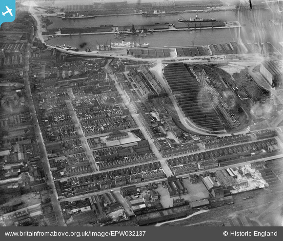
EPW032137 ENGLAND (1930). Aplha Road and environs, Millwall, 1930
    © Hawlfraint cyfranwyr OpenStreetMap a thrwyddedwyd gan yr OpenStreetMap Foundation. 2025. Trwyddedir y gartograffeg fel CC BY-SA.
  
Delweddau cyfagos (15)
Manylion
| Pennawd | [EPW032137] Aplha Road and environs, Millwall, 1930 | 
| Cyfeirnod | EPW032137 | 
| Dyddiad | May-1930 | 
| Dolen | |
| Enw lle | MILLWALL | 
| Plwyf | |
| Ardal | |
| Gwlad | ENGLAND | 
| Dwyreiniad / Gogleddiad | 537344, 179583 | 
| Hydred / Lledred | -0.021151786832548, 51.497995178467 | 
| Cyfeirnod Grid Cenedlaethol | TQ373796 | 
Pinnau
|  Alpha Road |   John W | Wednesday 28th of September 2016 03:05:37 PM | 
|  Mortons Preserves factory on Cuba Street |   moses72 | Friday 4th of December 2015 11:36:46 AM | 
|  Tobago Street |   moses72 | Friday 4th of December 2015 11:35:24 AM | 
|  Westferry Road |   moses72 | Tuesday 11th of November 2014 05:39:05 PM | 
|  Pride of the Isle pub, corner Cheval/Havannah Streets |   moses72 | Friday 21st of June 2013 02:10:37 PM | 
|  St Luke's Church |   moses72 | Wednesday 19th of June 2013 01:54:42 PM | 
|  Mentally Defective School, fronting in Cheval St |   PeterJames | Sunday 11th of November 2012 12:45:09 AM | 
|  Isle of Dogs School |   PeterJames | Sunday 11th of November 2012 12:43:36 AM | 
|  Millwall Central School |   PeterJames | Sunday 11th of November 2012 12:42:37 AM | 
Cyfraniadau Grŵp
| Should be titled "Alpha Road". |   John W | Wednesday 28th of September 2016 03:06:30 PM | 
| Shown in this view is the kink or dog leg in the top end of Alpha Grove, and Cuba St here runs straight to meet it, the building on  the corner where they meet is The Off Licence which looked very much like a pub...possibly classed as a Beerhouse. The dog leg of Alpha Grove ( then named Alpha Rd )and houses there, the off licence, the Court off Cuba St which had houses down it and that end of Cuba St was all cleared away for Docks expansion in the mid to late 30's. Cuba St now is slightly shorter with a dog leg at it's eastern end where it stops at the junction with Manilla St |   PeterJames | Saturday 20th of October 2012 11:05:31 PM | 
 
             
  ![[EPW032137] Aplha Road and environs, Millwall, 1930](http://britainfromabove.org.uk/sites/all/libraries/aerofilms-images/public/100x100/EPW/032/EPW032137.jpg) 
  
                                          ![[EPW032142] The Western Granaries and Grain Depot, Millwall, 1930](http://britainfromabove.org.uk/sites/all/libraries/aerofilms-images/public/100x100/EPW/032/EPW032142.jpg) 
 ![[EPW032143] The Western Granaries and Grain Depot, Millwall, 1930](http://britainfromabove.org.uk/sites/all/libraries/aerofilms-images/public/100x100/EPW/032/EPW032143.jpg) 
 ![[EPW032139] Western Granaries, the Grain Depot and Millwall Inner Dock, Millwall, 1930](http://britainfromabove.org.uk/sites/all/libraries/aerofilms-images/public/100x100/EPW/032/EPW032139.jpg) 
 ![[EPW032141] The Western Granaries and Grain Depot, Millwall, 1930](http://britainfromabove.org.uk/sites/all/libraries/aerofilms-images/public/100x100/EPW/032/EPW032141.jpg) 
 ![[EPW032140] The Western Granaries and Grain Depot, Millwall, 1930](http://britainfromabove.org.uk/sites/all/libraries/aerofilms-images/public/100x100/EPW/032/EPW032140.jpg) 
 ![[EPW032136] The Western Granaries and Grain Depot at Millwall Inner Dock, Millwall, 1930](http://britainfromabove.org.uk/sites/all/libraries/aerofilms-images/public/100x100/EPW/032/EPW032136.jpg) 
 ![[EPW032138] Western Granaries, Grain Depot and South Dock, Millwall, 1930](http://britainfromabove.org.uk/sites/all/libraries/aerofilms-images/public/100x100/EPW/032/EPW032138.jpg) 
 ![[EPW044128] West India and Millwall Docks, Isle of Dogs, from the south-west, 1934](http://britainfromabove.org.uk/sites/all/libraries/aerofilms-images/public/100x100/EPW/044/EPW044128.jpg) 
 ![[EAW009114] Millwall, Isle of Dogs, 1947](http://britainfromabove.org.uk/sites/all/libraries/aerofilms-images/public/100x100/EAW/009/EAW009114.jpg) 
 ![[EAW045810] West Ferry Road and environs, Millwall, 1952. This image was marked by Aerofilms Ltd for photo editing.](http://britainfromabove.org.uk/sites/all/libraries/aerofilms-images/public/100x100/EAW/045/EAW045810.jpg) 
 ![[EPW044135] South Dock, Millwall Inner Dock and environs, Isle of Dogs, 1934](http://britainfromabove.org.uk/sites/all/libraries/aerofilms-images/public/100x100/EPW/044/EPW044135.jpg) 
 ![[EPW006141] Millwall, Isle of Dogs, 1921](http://britainfromabove.org.uk/sites/all/libraries/aerofilms-images/public/100x100/EPW/006/EPW006141.jpg) 
 ![[EAW045808] Strafford Street and wharfage on the River Thames behind West Ferry Road, Millwall, 1952. This image was marked by Aerofilms Ltd for photo editing.](http://britainfromabove.org.uk/sites/all/libraries/aerofilms-images/public/100x100/EAW/045/EAW045808.jpg) 
 ![[EAW021721] A cityscape over Deptford and Millwall, Isle of Dogs, 1949. This image has been produced from a print.](http://britainfromabove.org.uk/sites/all/libraries/aerofilms-images/public/100x100/EAW/021/EAW021721.jpg)