
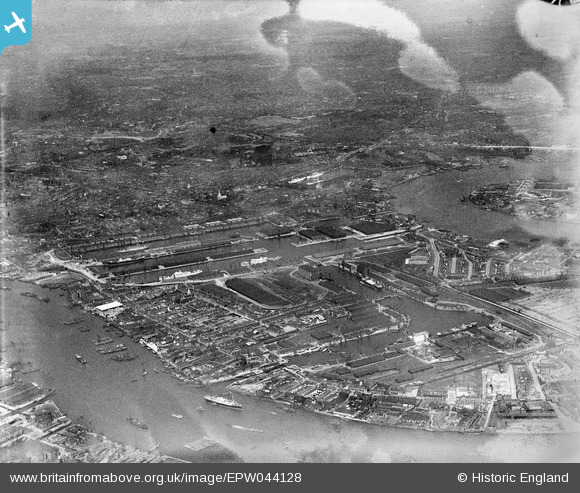
EPW044128 ENGLAND (1934). West India and Millwall Docks, Isle of Dogs, from the south-west, 1934
© Hawlfraint cyfranwyr OpenStreetMap a thrwyddedwyd gan yr OpenStreetMap Foundation. 2026. Trwyddedir y gartograffeg fel CC BY-SA.
Delweddau cyfagos (13)
EPW044128

EPW032142

EPW032139

EPW032137

EPW032141

EPW032138

EPW032140

EPW032143

EAW021721

EAW112904

EPW032136

EPW044132

EAW009803

Manylion
| Pennawd | [EPW044128] West India and Millwall Docks, Isle of Dogs, from the south-west, 1934 |
| Cyfeirnod | EPW044128 |
| Dyddiad | May-1934 |
| Dolen | |
| Enw lle | ISLE OF DOGS |
| Plwyf | |
| Ardal | |
| Gwlad | ENGLAND |
| Dwyreiniad / Gogleddiad | 537411, 179463 |
| Hydred / Lledred | -0.020233813606563, 51.496900436572 |
| Cyfeirnod Grid Cenedlaethol | TQ374795 |
Pinnau

yes |
Monday 19th of September 2022 05:58:59 PM | |
|
moses72 |
Monday 1st of July 2013 08:20:37 PM | |
|
moses72 |
Monday 1st of July 2013 08:18:43 PM | |
|
moses72 |
Monday 1st of July 2013 08:16:47 PM | |
|
moses72 |
Monday 1st of July 2013 08:15:28 PM |